
Share this page!

Custom Search
|
Click here to select another year
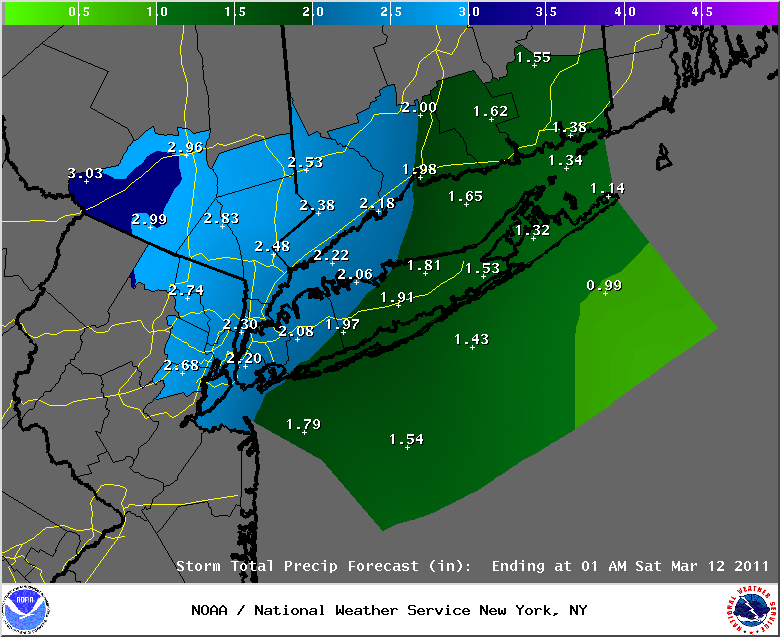
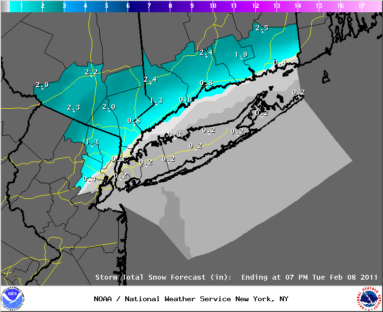
March 10th, 2011---:While there are differences between the 0z ETA/NAM and 0z GFS in regards to rain fall totals, the NWS is siding with the GFS as it is most in line with what is actually taking place right now. In other words, we're still on target to receive upwards of 2 inches of rain here in the NYC metro, with possibly heavier amounts falling in the already flood ravaged areas of NJ/NY and CT. Not good news at all for the folks who are living there. The NWS has issued a Flood Warning for many rivers in NJ. To read the specifics, click on the highlighted link. For locations in and around the NYC metro, the NWS has issued a Coastal Flood Advisory and this affects the entire NYC area, as well as Long Island. To sum up, the rain will become steadier and heavier later this afternoon and evening, with the worst of it coming in after dark. Stay tuned to your local news affiliates for the latest watches and warnings, and most importantly....stay warm and dry! Just think happy thoughts as spring is just around the corner! Top Image: The latest rain fall totals forecast issued by the NWS.
March 9th, 2011---: Not much more to really say as far as any updates are concerned. We're still looking on target to receive a significant amount of rain over the next 36 hours beginning early Thursday morning and ending Friday afternoon. The Governor of NJ has issued a state of emergency and with good reason. There is already significant flooding taking place in towns like Wayne, NJ as well as many other towns in northern and central NJ, and this upcoming rain event will only make things worse. Stay tuned to your local news outlets if you live in any of the flood prone areas around the NY/NJ and CT areas.
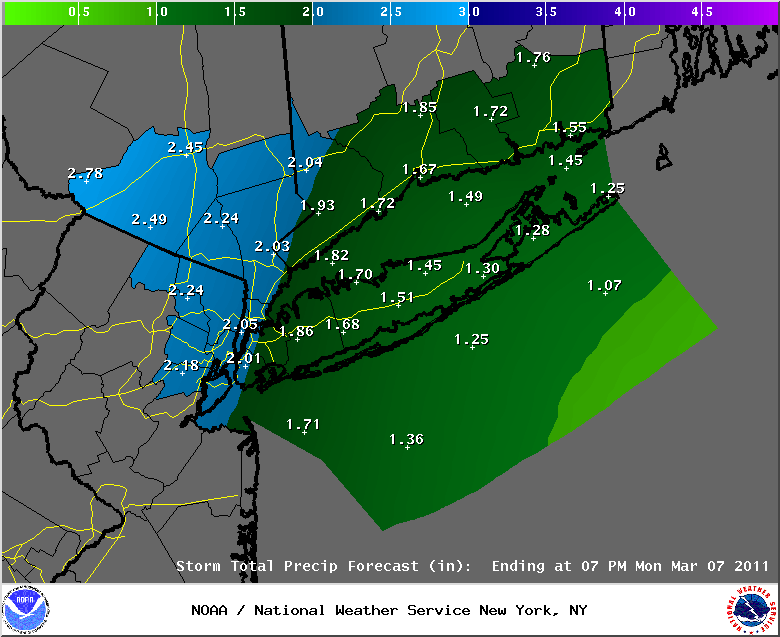
March 8th, 2011---: Here we go again! And this time around we're looking at much more rain than what we received here in the city the other day. Current rain fall totals forecasts for Thursday are showing another 2-3+ inches of rain for the NYC Tri-State area and this will only make the flooding situation in New Jersey and other parts of the area worse! Not surprisingly, the National Weather Service has issued a flash flood watch for this upcoming rain event. If you're interested in reading the text regarding this watch, click here. The image below shows the latest rain fall totals graphics issued by the NWS at 8pm this evening. More details tomorrow but as it's looking right now, Thursday and especially Thursday evening/night will be a real mess! The rain will come to an end during the day on Friday.
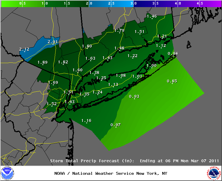
March 7th, 2011---: Here are the rain fall totals from around the NYC metro from our latest storm
CONNECTICUT
...FAIRFIELD COUNTY...
DANBURY 4.43 500 AM 3/07 COOP OBSERVER
3 SSE BROOKFIELD 4.20 700 AM 3/07 COCORAHS
SHELTON 2.60 550 AM 3/07 PUBLIC
NORWALK 2.10 650 AM 3/07 PUBLIC
BRIDGEPORT AIRPORT 1.51 700 AM 3/07 ASOS
...MIDDLESEX COUNTY...
HADDAM 3.80 523 AM 3/07 PUBLIC
DEEP RIVER 3.42 820 AM 3/07 TRAINED SPOTTER
...NEW HAVEN COUNTY...
BETHANY 2.95 815 AM 3/07 TRAINED SPOTTER
SOUTHBURY 2.74 1100 AM 3/07 TRAINED SPOTTER
MERIDEN 2.56 700 AM 3/07 ASOS
NORTH HAVEN 2.02 630 AM 3/07 PUBLIC
NEW HAVEN 1.16 700 AM 3/07 ASOS
NEW JERSEY
...BERGEN COUNTY...
RIVERVALE 4.00 415 AM 3/07 PUBLIC
PARK RIDGE 3.61 900 AM 3/07 AFWS
RIDGEWOOD 3.60 621 AM 3/07 TRAINED SPOTTER
WOODCLIFF LAKE 3.51 800 AM 3/07 AFWS
OAKLAND 3.44 720 AM 3/07 PUBLIC
FRANKLIN LAKES 3.19 900 AM 3/07 AFWS
1 ESE OAKLAND 3.09 700 AM 3/07 COCORAHS
SADDLE BROOK 3.05 600 AM 3/07 TRAINED SPOTTER
RAMSEY 3.03 800 AM 3/07 TRAINED SPOTTER
GARFIELD 2.94 938 AM 3/07 TRAINED SPOTTER
LYNDHURST 2.59 700 AM 3/07 PUBLIC
LODI 2.55 800 AM 3/07 AFWS
TETERBORO 2.43 700 AM 3/07 ASOS
1 W TENAFLY 2.10 630 AM 3/07 COCORAHS
...ESSEX COUNTY...
VERONA 3.40 700 AM 3/07 TRAINED SPOTTER
MAPLEWOOD 2.66 900 AM 3/07 AFWS
CALDWELL 2.34 800 AM 3/07 ASOS
NEWARK AIRPORT 1.97 700 AM 3/07 ASOS
...HUDSON COUNTY...
HARRISON 2.21 800 AM 3/07 COOP OBSERVER
...PASSAIC COUNTY...
RINGWOOD 3.78 800 AM 3/07 AFWS
CHARLOTTEBURG 3.07 800 AM 3/07 COOP OBSERVER
WEST MILFORD 2.95 900 AM 3/07 AFWS
1 WNW LITTLE FALLS 2.87 800 AM 3/07 COCORAHS
HAWTHORNE 2.83 520 AM 3/07 TRAINED SPOTTER
WEST PATERSON 2.61 800 AM 3/07 AFWS
NEW YORK
...NASSAU COUNTY...
MUTTONTOWN 1.95 930 AM 3/07 TRAINED SPOTTER
LYNBROOK 1.80 815 AM 3/07 PUBLIC
VALLEY STREAM 1.63 830 AM 3/07 PUBLIC
MERRICK 1.57 500 AM 3/07 TRAINED SPOTTER
...NEW YORK COUNTY...
CENTRAL PARK 2.10 700 AM 3/07 ASOS
...ORANGE COUNTY...
TUXEDO PARK 4.39 700 AM 3/07 PUBLIC
2 SE MONROE 3.95 800 AM 3/07 COCORAHS
STERLING FOREST 3.47 800 AM 3/07 AFWS
NEW WINDSOR 2.74 300 PM 3/07 TRAINED SPOTTER
MONTGOMERY 2.57 800 AM 3/07 ASOS
NEWBURGH 2.46 900 AM 3/07 TRAINED SPOTTER
WARWICK 2.38 841 AM 3/07 TRAINED SPOTTER
...PUTNAM COUNTY...
BALDWIN PLACE 3.66 730 AM 3/07 TRAINED SPOTTER
8 NE COLD SPRINGS 3.63 700 AM 3/07 COCORAHS
...QUEENS COUNTY...
NYC/LA GUARDIA 2.16 700 AM 3/07 ASOS
REGO PARK 1.59 1000 AM 3/07 TRAINED SPOTTER
NYC/JFK AIRPORT 1.32 700 AM 3/07 ASOS
...ROCKLAND COUNTY...
THIELLS 4.81 930 AM 3/07 FIRE AND EM SERVICES
NANUET 4.60 500 AM 3/07 TRAINED SPOTTER
VALLEY COTTAGE 4.05 500 AM 3/07 TRAINED SPOTTER
WEST NYACK 3.86 930 AM 3/07 FIRE AND EM SERVICES
HILLBURN 3.81 930 AM 3/07 FIRE AND EM SERVICES
SPRING VALLEY 3.44 930 AM 3/07 FIRE AND EM SERVICES
TAPPAN 3.02 930 AM 3/07 FIRE AND EM SERVICES
...SUFFOLK COUNTY...
CENTERPORT 1.54 700 AM 3/07 COOP OBSERVER
ISLIP 1.28 700 AM 3/07 PUBLIC
STONY BROOK 1.14 135 AM 3/07 SKYWARN SPOTTER
EAST FARMINGDALE 1.02 700 AM 3/07 ASOS
UPTON 0.75 100 AM 3/07 NWS OFFICE
...WESTCHESTER COUNTY...
YORKTOWN HEIGHTS 4.64 636 AM 3/07 TRAINED SPOTTER
2 NW SOUTH SALEM 4.57 800 AM 3/07 COCORAHS
WHITE PLAINS 3.59 1000 AM 3/07 TRAINED SPOTTER
RYE 2.15 907 AM 3/07 PUBLIC
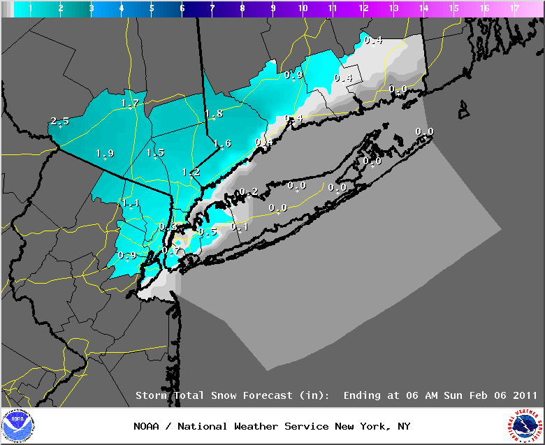
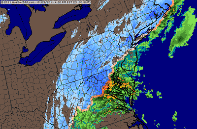
March 6th, 2011---: The heavy rain is on the way for the NYC metro later today and this evening. Current radar trends show the rain moving in from the south and west. For now at least we're just experiencing some on and off showers here in the city, but as you can see from the regional radar below, it won't be long now until the steadier and heavier rain moves into the area. Areas to our far north and west will be seeing all snow from this, and winter storm warnings are out for those locations, but for us here along the coast, we'll be seeing an all rain event. If you have plans to be out and about later this afternoon and evening, be wary of ponding of water on roadways as there will be localized flooding. The current forecast is calling for around 1 1/2 inches of rain for the city itself. For the latest info regarding this storm direct from the National Weather Service, click here. While there are no official flood watches up for the NYC metro, there are for areas just to our west. For details on that, click here. Top Image: Current regional radar animation showing the rain and snow moving towards the area from the south and west. Bottom Image: Current rain fall totals forecast issued by the NWS at 8am for the NYC metro and surrounding
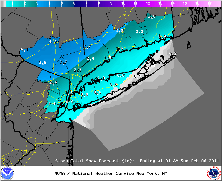
March 4th, 2011---: I tell you what, if this was snow we were looking at for late this weekend here in the NYC area, we'd be talking in terms of feet, not inches! But alas, this next storm will once again be all rain for the NYC metro, the snow from this system will remain well north and west of the NYC area. Locations in upstate NY could be looking at anywhere from 5-10 inches depending on how far north you are. Albany, NY right now is looking at snow fall totals in the 6 inch range. For us here in NYC, the rain will begin late on Saturday, but will become steady on Sunday and Sunday night which is when the heaviest rain is expected. The rain will finally let up during the morning on Monday when the storm system departs the area. Needless to say, this is going to be a very long duration event. When all is said and done, locations in and around the NYC metro could be looking at close to 2 inches of rain. The National Weather Service is mentioning potential flooding in their latest Hazardous Weather Outlook. There are already flood watches issued for areas west of the city, and I would not be surprised if watches are issued for our area later this evening. More details tomorrow as we get closer to the storms onset. But what seems certain is that we'll have a very wet end to the weekend, so plan for a very messy Sunday and Sunday night. Below image: The latest rain fall totals forecast issued by the NWS at 5pm for the NYC Metro and surrounding.
March 2nd, 2011---: After two very nice days here in the NYC metro we're about to get a shot of reality that yep....winter ain't over yet! But don't fret, the big time chill down isn't going to last very long. After a very cold night tonight, and a very cold day tomorrow (highs expected to be around 30 degrees) we will begin to warm back up towards the weekend. While the upcoming weekend will be much warmer than tomorrow, we will also be heading into a period of unsettled weather and rain can be expected from time to time this weekend, and into the early part of next week. Below image: forecast low temperatures for tomorrow morning (March 3rd). Yikes! Not liking the looks of that, spring can't come soon enough I say!
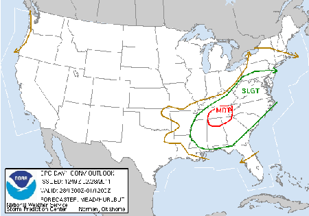
February 28th, 2011---: What a mess of a day here in NYC! Heavy rains and even some flashes of lightning moved in around 3:30 this morning and it hasn't let up yet. Already received almost .50 inches here in my neighborhood of Rego Park, Queens with a LOT more on the way. What's more, we could even see some severe weather later on this afternoon, all though areas to our south are under a much higher risk of seeing severe weather than we are here in the city. Still though, it's possible so I'll be keeping an eye out later today. The rain will let up briefly later this morning, before more rain, heavy at times, moves in later this afternoon and evening. It's at this time we could see some thunderstorms move though, but again, for the time being the overall risk for severe weather in and around the NYC metro is on the low side. The Storm Prediction Center has us in a 5-10% risk. Localized flooding is much more likely at this time so be careful while out driving, and be on the lookout for ponding of water on area roads. Another potential hazard for today are strong winds. These strong winds would be even more likely in areas that experience thunderstorms later today. For any of my weather friends reading this from down south, the SPC has a moderate risk for severe weather out for parts of TN, AL, GA, MS and adjacent states. There is also a heightened risk for tornadoes, and the greatest risk at this time is centered around TN, northern AL and MS. If you live in these areas please keep an eye to the sky, and keep your NOAA radio on! If you do not have a NOAA weather radio, keep it tuned to you local news stations. Below left: Current regional radar animation showing heavy rain and thunderstorms scattered throughout the NY/PA area. Below right: Current SPC severe weather outlook as of 8am ET
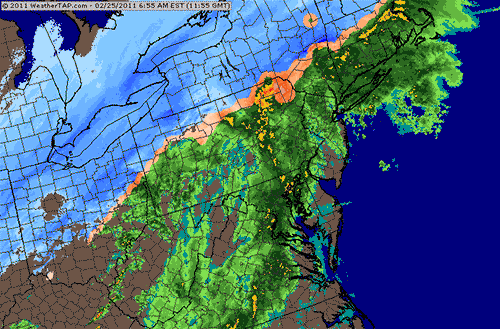
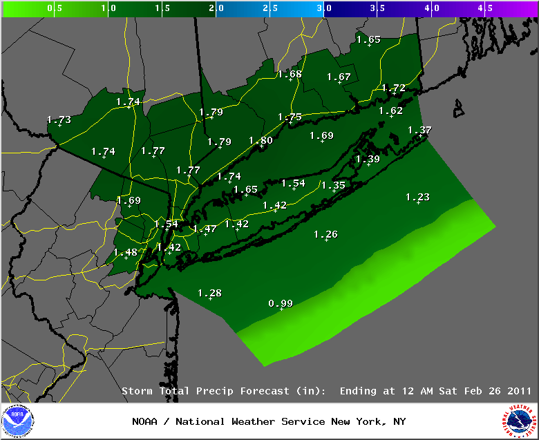
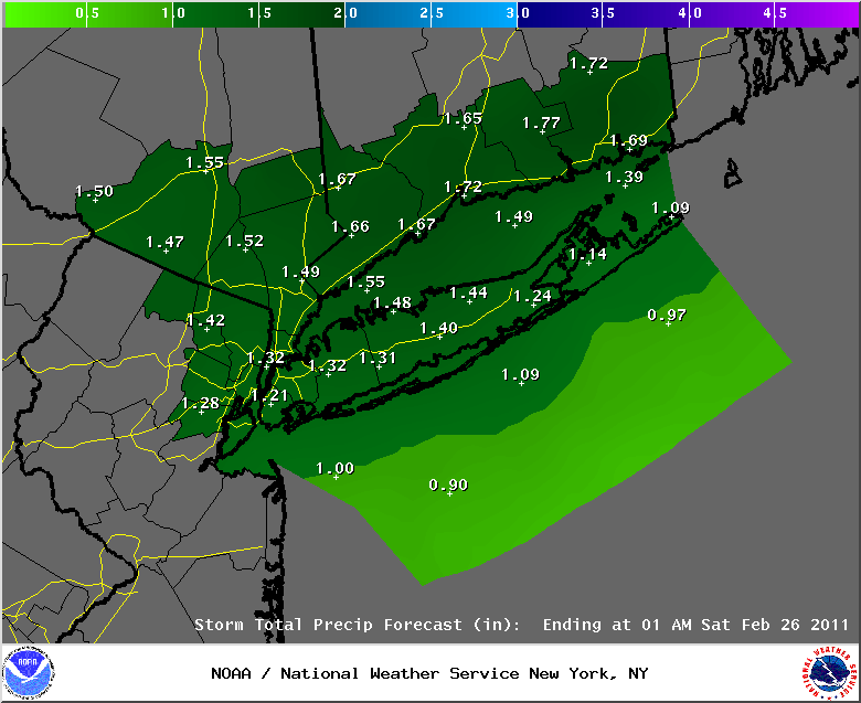
February 25th, 2011---: A High Wind Warning is now in effect for the NYC metro and surrounding areas from 11am this morning, until 11pm this evening. As I type this at 8am the heavy rains are falling all over the northeast, including here in the NYC area as well. My rain gage has already recorded .73 inches of rain and there is plenty more on the way! The forecast for up to 2" of rain total seems to be on target. There are already several reports of flooding in poor drainage areas so be on your guard for that if you're driving around the area this morning. The rain will let up later today as a cold front moves through the area. This cold front could be preceded by some rumbles of thunder, but the bigger story will be the very strong winds that will accompany the passage of the front later this afternoon. The strong winds will continue behind the front as well and we could see gusts up to 60+ mph area wide. Many trees and power lines will come down, and expect some power outages as well. Be very careful if you plan to be out and about later today, every year there are people killed by falling trees and power lines so be on your guard! Top Image: Regional radar animation courtesy of WeatherTap showing heavy rain falling throughout the northeast this morning. Note that the rain/snow line is very far north of us for a change. Bottom Image: Current rain fall totals forecast issued by the NWS at 4am.
February 24th, 2011---: A High Wind Watch is now in effect for the NYC metro, and this watch may have to be upgrading to a warning at some point during the night. For now, expect moderate to at times heavy rain to move into the NYC area sometime after midnight. The morning commute tomorrow will be a mess for sure! Along with the rain, the winds as mentioned above will also be an issue, and we could see many trees and power lines come down over the next 24 hours. Be careful if you plan to be out an about tomorrow! The bulk of the rain is expected to move out of the area by the early afternoon. We could even see a thunderstorm tomorrow as the cold front passes through the area. As the front passes through during the afternoon and early evening, the winds will really kick into high gear. It's at this time we're expecting the strongest winds, and we could see gusts up to 60mph during the evening hours. So to sum it all up, tomorrow will be a very crappy day! Lots of shredded umbrellas will litter the streets of NYC for sure! Below image: current rain fall totals forecast issued by the National Weather Service at 8:30pm
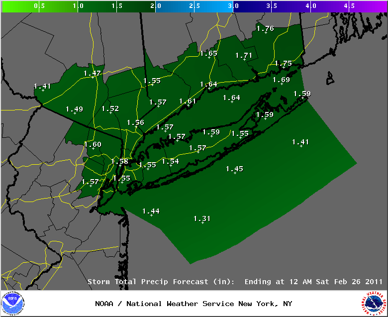
February 23rd, 2011---: Another major storm is on the horizon for late this week, but this time around, we're looking at heavy rain and NOT heavy snow. The reason being is that the low pressure responsible for the adverse weather will track right over the NYC area, or even a little bit to the north of us. It's this all important track that plays a major role in determining precipitation type. In this case, there will be plenty of warm air working into the area and thus, we'll see a rain event. And on top of that, we could experience some pretty strong winds later on Thursday night and into the day on Friday! I think we'll most definitely see a wind advisory posted for parts of the area, I'll be keeping tabs on that. For now though, plan for a very crappy day later on Thursday, Thursday night and into the day on Friday. For more details regarding this upcoming storm direct from the NWS, click here. Below image: Current rain fall totals forecast issued by the National Weather Service at 3:30pm this afternoon.
February 21st, 2011---: Snow fall totals posted by the National Weather Service for the NYC metro and surrounding area. Here in my neighborhood of Rego Park, Queens we received 2.4 inches. Not a lot but enough to make travel pretty tough early this morning.
CONNECTICUT
...FAIRFIELD COUNTY...
GREENWICH 7.5 1045 AM 2/21 PUBLIC
DARIEN 5.0 1100 AM 2/21 CT DOT
NEW CANAAN 4.6 800 AM 2/21 SKYWARN SPOTTER
WEST NORWALK 4.5 830 AM 2/21 PUBLIC
NORWALK 4.0 825 AM 2/21 PUBLIC
STAMFORD 4.0 800 AM 2/21 SKYWARN SPOTTER
WESTON 4.0 900 AM 2/21 SKYWARN SPOTTER
WESTPORT 4.0 900 AM 2/21 SKYWARN SPOTTER
BRIDGEPORT AIRPORT 2.7 100 PM 2/21 COOP OBSERVER
SHELTON 2.6 810 AM 2/21 PUBLIC
DANBURY 2.0 930 AM 2/21 SKYWARN SPOTTER
...MIDDLESEX COUNTY...
HADDAM 1.5 1100 AM 2/21 CT DOT
1 S PORTLAND 1.5 800 AM 2/21 COCORAHS
...NEW HAVEN COUNTY...
3 ESE MILFORD 2.7 939 AM 2/21 COCORAHS
MILFORD 2.0 1100 AM 2/21 CT DOT
WATERBURY 2.0 1100 AM 2/21 CT DOT
NEW HAVEN 1.7 1000 AM 2/21 BROADCAST MEDIA
BEACON FALLS 1.5 1100 AM 2/21 CT DOT
SOUTHBURY 1.5 1100 AM 2/21 CT DOT
MERIDEN 1.0 1100 AM 2/21 CT DOT
...NEW LONDON COUNTY...
COLCHESTER 1.3 1100 AM 2/21 CT DOT
GROTON 1.3 1100 AM 2/21 CT DOT
NEW JERSEY
...BERGEN COUNTY...
MAHWAH 7.6 900 AM 2/21 SKYWARN SPOTTER
RAMSEY 7.3 830 AM 2/21 SKYWARN SPOTTER
1 SSE OAKLAND 7.1 845 AM 2/21 COCORAHS
RIVERVALE 7.0 1100 AM 2/21 SKYWARN SPOTTER
ALLENDALE 7.0 1108 AM 2/21 PUBLIC
1 SSE GLEN ROCK 6.8 815 AM 2/21 COCORAHS
FAIR LAWN 5.9 1120 AM 2/21 SKYWARN SPOTTER
BERGENFIELD 5.7 900 AM 2/21 SKYWARN SPOTTER
1 NNW DEMAREST 5.7 830 AM 2/21 COCORAHS
ELMWOOD PARK 5.7 830 AM 2/21 SKYWARN SPOTTER
LODI 5.5 1029 AM 2/21 PUBLIC
ORADELL 5.4 900 AM 2/21 SKYWARN SPOTTER
EAST RUTHERFORD 5.0 1109 AM 2/21 SKYWARN SPOTTER
GARFIELD 4.2 800 AM 2/21 SKYWARN SPOTTER
1 E SADDLE BROOK TWP 4.0 830 AM 2/21 COCORAHS
...ESSEX COUNTY...
CEDAR GROVE 5.2 835 AM 2/21 PUBLIC
WEST ORANGE 4.3 900 AM 2/21 PUBLIC
MONTCLAIR 4.0 930 AM 2/21 PUBLIC
NEWARK AIRPORT 2.7 100 PM 2/21 FAA CONTRACT OBSERVER
...HUDSON COUNTY...
HARRISON 3.5 945 AM 2/21 SKYWARN SPOTTER
N HARRISON 3.0 800 AM 2/21 COCORAHS
HOBOKEN 2.8 930 AM 2/21 SKYWARN SPOTTER
...PASSAIC COUNTY...
RINGWOOD 8.0 930 AM 2/21 SKYWARN SPOTTER- 900 FT
WEST MILFORD 7.9 1030 AM 2/21 SKYWARN SPOTTER-1100 FT
1 S WANAQUE 7.5 800 AM 2/21 COCORAHS
WAYNE 7.0 858 AM 2/21 SKYWARN SPOTTER
HASKELL 6.5 1100 AM 2/21 SKYWARN SPOTTER
1 SSE HAWTHORNE 6.5 900 AM 2/21 COCORAHS
1 WNW LITTLE FALLS T 5.5 900 AM 2/21 COCORAHS
...UNION COUNTY...
ELIZABETH 2.9 900 AM 2/21 SKYWARN SPOTTER
NEW YORK
...BRONX COUNTY...
PELHAM PARKWAY HOUSE 4.7 857 AM 2/21 SKYWARN SPOTTER
PARKCHESTER 3.9 1110 AM 2/21 PUBLIC
BRONX 3.2 850 AM 2/21 BRONX ZOO
...NASSAU COUNTY...
LAUREL HOLLOW 4.5 1000 AM 2/21 PUBLIC
GARDEN CITY 3.2 1000 AM 2/21 PUBLIC
SYOSSET 3.2 1130 AM 2/21 NES EMPLOYEE
NEW HYDE PARK 3.0 1133 AM 2/21 SKYWARN SPOTTER
WANTAGH 3.0 100 PM 2/21 SKYWARN SPOTTER
BELLEROSE 3.0 900 AM 2/21 PUBLIC
LYNBROOK 3.0 1000 AM 2/21 SKYWARN SPOTTER
LEVITTOWN 3.0 900 AM 2/21 PUBLIC
PLAINVIEW 3.0 939 AM 2/21 SKYWARN SPOTTER
WOODMERE 3.0 1000 AM 2/21 PUBLIC
VALLEY STREAM 2.7 900 AM 2/21 SKYWARN SPOTTER
MERRICK 2.5 900 AM 2/21 PUBLIC
...NEW YORK COUNTY...
CENTRAL PARK 3.2 100 PM 2/21 CENTRAL PARK ZOO
...ORANGE COUNTY...
TUXEDO PARK 7.4 1221 PM 2/21 PUBLIC
WARWICK 6.7 930 AM 2/21 SKYWARN SPOTTER
MIDDLETOWN 6.0 1100 AM 2/21 PUBLIC
2 SE MONROE 5.7 800 AM 2/21 COCORAHS
FLORIDA 5.5 1130 AM 2/21 PUBLIC
MONROE 5.1 815 AM 2/21 PUBLIC
HIGHLAND MILLS 5.0 230 PM 2/21 PUBLIC
NEW WINDSOR 4.2 1030 AM 2/21 PUBLIC
GOSHEN 3.8 1100 AM 2/21 SKYWARN SPOTTER
...PUTNAM COUNTY...
PUTNAM VALLEY 3.3 1116 AM 2/21 PUBLIC
BREWSTER 3.0 1239 PM 2/21 PUBLIC
MAHOPAC 3.0 1111 AM 2/21 SKYWARN SPOTTER
...QUEENS COUNTY...
WHITESTONE 3.9 845 AM 2/21 PUBLIC
ASTORIA 3.8 900 AM 2/21 PUBLIC
NYC/LA GUARDIA 3.5 100 PM 2/21 FAA CONTRACT OBSERVER
WOODSIDE 3.5 915 AM 2/21 SKYWARN SPOTTER
REGO PARK 2.4 900 AM 2/21 SKYWARN SPOTTER
NYC/JFK AIRPORT 2.3 100 PM 2/21 FAA CONTRACT OBSERVER
...ROCKLAND COUNTY...
NEW HEMPSTEAD 7.0 1010 AM 2/21 PUBLIC
ROCKLAND LAKE 7.0 900 AM 2/21 SKYWARN SPOTTER
NYACK 6.0 810 AM 2/21 PUBLIC
STONY POINT 5.5 830 AM 2/21 SKYWARN SPOTTER
...SUFFOLK COUNTY...
MOUNT SINAI 5.3 100 PM 2/21 NWS EMPLOYEE
SETAUKET 5.0 1100 AM 2/21 NWS EMPLOYEE
SOUND BEACH 4.8 1030 AM 2/21 NWS EMPLOYEE
CENTEREACH 4.8 930 AM 2/21 NWS EMPLOYEE
PORT JEFFERSON 4.6 1000 AM 2/21 PUBLIC
CENTERPORT 4.5 1030 AM 2/21 PUBLIC
CORAM 4.5 905 AM 2/21 PUBLIC
EAST NORTHPORT 4.5 945 AM 2/21 SKYWARN SPOTTER
STONY BROOK 4.5 840 AM 2/21 SKYWARN SPOTTER
SHOREHAM 4.3 1200 PM 2/21 SKYWARN SPOTTER
BAITING HOLLOW 4.2 1255 PM 2/21 PUBLIC
MEDFORD 4.2 1000 AM 2/21 SKYWARN SPOTTER
NORTHPORT 4.2 1030 AM 2/21 PUBLIC
UPTON 4.2 100 PM 2/21 NWS OFFICE
MANORVILLE 4.0 1050 AM 2/21 PINE HILLS GOLF CLUB
SELDEN 4.0 1135 AM 2/21 PUBLIC
NORTH BABYLON 3.8 1000 AM 2/21 PUBLIC
QUOGUE 3.8 1100 AM 2/21 PUBLIC
1 SSW JAMESPORT 3.7 900 AM 2/21 COCORAHS
SHIRLEY 3.6 1108 AM 2/21 SKYWARN SPOTTER
HAMPTON BAYS 3.5 1000 AM 2/21 PUBLIC
RONKONKOMA 3.4 956 AM 2/21 NWS EMPLOYEE
ISLIP AIRPORT 3.3 100 PM 2/21 FAA CONTRACT OBSERVER
1 WNW EAST MORICHES 3.1 900 AM 2/21 COCORAHS
MATTITUCK 3.1 1230 PM 2/21 COOP OBSERVER
CUTCHOGUE 3.0 1200 PM 2/21 PUBLIC
SAYVILLE 2.9 900 AM 2/21 NWS EMPLOYEE
PATCHOGUE 2.8 100 PM 2/21 NWS EMPLOYEE
LINDENHURST 2.6 100 PM 2/21 SKYWARN SPOTTER
ORIENT 2.3 930 AM 2/21 PUBLIC
...WESTCHESTER COUNTY...
PORT CHESTER 7.5 1200 PM 2/21 PUBLIC
MAMARONECK 7.4 1000 AM 2/21 PUBLIC
CHAPPAQUA 7.0 1100 AM 2/21 PUBLIC
RYE BROOK 7.0 1120 AM 2/21 PUBLIC
THORNWOOD 7.0 900 AM 2/21 PUBLIC
SCARSDALE 6.2 1116 AM 2/21 SKYWARN SPOTTER
ARMONK 6.1 820 AM 2/21 PUBLIC
HARRISON 6.1 830 AM 2/21 PUBLIC
YONKERS 6.0 900 AM 2/21 SKYWARN SPOTTER
BRONXVILLE 5.5 1000 AM 2/21 PUBLIC
MOUNT VERNON 5.0 1030 AM 2/21 PUBLIC
MOUNT KISCO 4.5 755 AM 2/21 PUBLIC
YORKTOWN HEIGHTS 4.0 1109 AM 2/21 SKYWARN SPOTTER
2 NW SOUTH SALEM 2.9 800 AM 2/21 COCORAHS
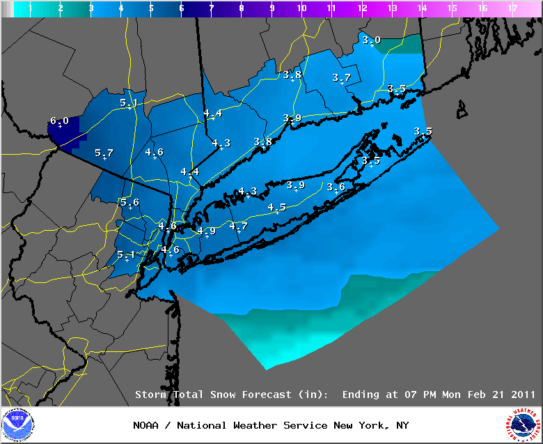
February 20th, 2011---: Evening Update | The National Weather Service has bumped up it's snow fall totals forecast for the NYC metro and surrounding. Looking more like a 3-5 inch storm now. Yes, welcome to the uncertain world of the weather! The models are coming together on an all snow scenario and the latest 18z NAM and 12z GFS are putting out about .50 inches of liquid precip from this storm which would equate to 5 inches of snow give or take. Either way, it's going to be a very messy morning commute tomorrow so be careful and take your time if you plan to be out and about tomorrow morning. The good thing is that it's President's Day so many people have the day off. Below are the updated snow fall total graphics issued by the NWS at 3:30 this afternoon. For the time being it appears that we'll be spared from the second round of precip later Monday night and into Tuesday. We'll be on the northern fringe of the precipitation it seems. Stay tuned though as with all things weather, things can change.
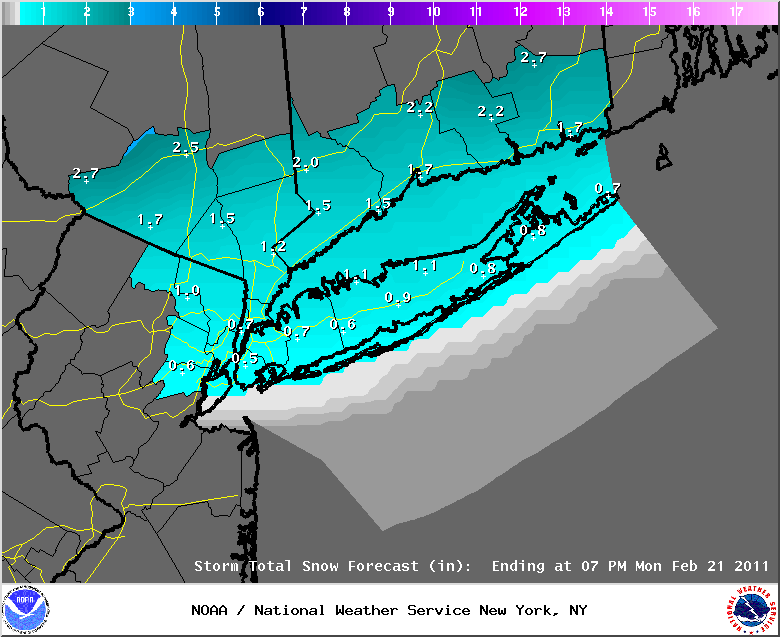
February 20th, 2011---: Forecast models are converging on a colder solution for our upcoming storm. The latest 12z NAM has a track just south of the NYC area which would mean more cold air in place, and a mostly snow event for our area. The 0z GFS has been bouncing around a bit in terms of track over the last few runs and currently has a low track over the NYC metro bringing with it a mix or rain and snow. The latest 09z SREF also sides with the NAM and has a track just south of the area, and the official National Weather Service forecast seems to be siding with both the NAM and SREF. I just checked the latest 12z NAM snow depth forecast and it's putting down about 3 inches of snow in and around the NYC Metro. As a result, the NWS has issued a Winter Weather Advisory for our entire area, to read the official text direct from the NWS web site, click here. As far as the one two punch of this system I mentioned yesterday, the secondary low that is forecast to traverse the area to our south may be a bit too far south to give us anything more than some fringe effects. These effects would be felt over night tomorrow night and into Tuesday if they were to occur. Details are still a bit foggy with the NAM showing more of a hit from this secondary low than the GFS, but right now it looks like areas to our south and west could see a shot of snow, while the NYC metro escapes with just some fringe effects. Stay tuned. So to sum up, expect anywhere from 2-4 inches of snow in and around the NYC metro by tomorrow afternoon. There could also be a period where some rain mixes in, especially as things wind down later tomorrow morning and into the afternoon. By this time we'll have a good idea on what the second wave of precip will have in store for us. I'll post another update later tonight.
February 19th, 2011---: WOW, talk about a blast of reality! The sprink like temperatures of yesterday are most definitely gone! Strong winds have been buffeting the NYC metro since last night and these strong winds will continue throughout the rest of today. Expect wind gusts as high as 60mph at times! The National Weather Service still has a wind advisory in affect until midnight tonight because of this. Sunday should feature less wind, but this will be the calm before the storm. Right now it's beginning to look like we *could* see a little more snow than originally forecast. This will all depend on just how far south the first low pressure system tracks as it traverses the northeast. A low track a little south of Long Island and more cold air would be in place bringing more snow in than previously thought. A track over, or just to the north of Long Island and we'll see snow at the onset, and a quick change over to rain shortly there after. Notice I mentioned the "first" low pressure system above, this a two part storm, the first part mentioned above will begin on Sunday night and will last through the day on Monday. After the initial low departs the area, another low pressure will track off shore possibly bringing another shot of rain or snow to the area late Monday and into Tuesday morning. Still some model descrepancies with this secondary low as well so several things still need to be ironed out. If the first part of the storm features more snow than rain we could be looking at snow fall totals in the 1 to 2 inch range here at the coast, followed by another inch or so from the second coastal storm. All in all though the official forecast at this time is only calling for up to an inch of snow here at the coast, with possibly low end advisory level snow fall totals north and west of NYC in the Lower Hudson Valley and parts of Connecticut. Those areas could be looking at up to 4 inches of snow between both systems. As far as what the models are showing, the 0z GFS is showing a more rainy scenario for the NYC metro, where as the 06z GFS is showing a more snowy scenario with a low track a bit further south. Both runs show minimal, if any impacts from the secondary off shore low. The 0z NAM is showing a mix of snow and rain at the onset of the first wave of precipitation Sunday night, followed by rain for the day on Monday with a change over back to snow for Monday night and Tuesday morning as the secondary low tracks off shore to our south. Will continue to monitor things and will have another update later this evening. Regardless, this is not going to be a major hitter in terms of snow fall but more of a nuisance. Either way, if you plan to be out there on the roads over the next 48 hours be careful as the roads will most certainly be slick in spots. Below Image: current snow fall totals forecast from the NWS.
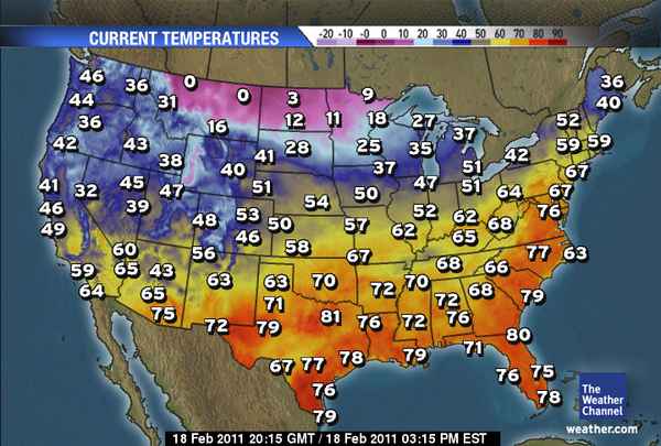
February 18th, 2011---: What a nice break from reality! Temperatures today spiked into the mid and upper 60s throughout the NYC metro and man did it feel nice! I did my best to get out there and enjoy it since reality is about to come crashing back down on us. Unfortunately the spring like temperatures will come to an end this evening on the heels of some very strong winds. So strong in fact the National Weather Service has issued a wind advisory for the entire area from 3am Saturday morning until midnight tomorrow night. This wind advisory may have to be upgraded to a high wind warning if the winds end up stronger than forecast, but regardless on whether this upgrade happens or not...expect VERY strong winds late tonight and into the day tomorrow. Please be sure to secure all loose objects around your home as they will fly around if left unsecured. The winds will relax a bit on Sunday before a mix of rain and snow move into the area for the beginning of the new work week. Precipitation in the form of rain at the coast, and a rain/snow mix north and west will move in late Sunday night and this will continue through the day on Monday. For us here in the NYC metro, expect plain rain through the day on Monday before a change over back to snow occurs later Monday evening as the temperatures drop through the 20s. Any left over snow showers will taper off Tuesday morning but no worries, at this time we're not expecting much, if anything in the way of accumulation. After that things should be quiet through mid week. Image Below: what a change from a few days ago! Temperatures as of the 3 o'clock hour, man I wish they could last longer.
February 14th, 2011---: First off, Happy Valentine's Day everyone! What a warm day it was here in NYC today! Well, after what we've been through for most of this winter, temperatures in the 50s seem warm lol. Unfortunately though, we will have a brief cool down tomorrow, well actually temperatures will drop like a rock tonight and then we'll be back in the 20s tomorrow morning, with highs tomorrow only reaching the 30s. This chill down will only last a day however, and by Wednesday we'll be rebounding once again into the upper 40s. By Thursday and Friday we could be approaching 60 degrees here in the city! Coastal locations will see temperatures a bit cooler though due to the winds coming off the cooler ocean waters. As I'm sure you have noticed, we have transitioned into a more tranquil pattern, something that could not be said for the entire winter up until this point. For the time being, I do not see any big storms on the horizon. Enjoy it while it lasts!
February 11th, 2011---: What a nice break this has been, as much as I love storms I have to say, the break from the weekly storm train has been nice. And what's more, it appears that a warm up is in store for the NYC metro! One more cold day today and then we begin to turn the corner towards warmer weather. An upper level trough will traverse the northeast this weekend and we could see some intermittent rain and snow showers here and there through Sunday night. After that, the upper level flow will begin to flatten out into more of a zonal flow, and by early to mid week, our temperatures will be topping out in the mid and upper 40s! By late week dare I say it, we could be well into the 50s! If the long range ECMWF is right, then next weekend will feature spring like temperatures here in the northeast! But don't get your hopes up just yet, that's still a week out and much can change between now and then. A quick check of the GFS and it appears for now to be siding with the ECMWF. Fingers crossed. So to sum up, a bit of a blustery weekend ahead with some rain and snow showers for the NYC metro, but overall no where near as bad as we have seen lately. After that, expect temperatures to warm as the new work week progresses. I will have another update on Sunday afternoon. In the meantime, enjoy the weekend everyone!
February 7th, 2011---: The NYC metro will be affected by yet another storm late tonight and into tomorrow, but once again...we're looking at a mostly, if not all rain event here at the coast. Areas to the north of NYC could see a few inches of accumulating snow, but even there the snow fall totals should be minimal. After tomorrow, the US will transition into a more progressive pattern, or "Zonal" flow where the jet stream will be moving more or less west to east with no major troughs on the maps for a change. It was these troughs in the east that were helping steer one storm after another up the coast. In a progressive pattern, storm systems move quickly from west to east and are usually steered right off the east coast and out to sea. This should give the northeast a bit of a break from any major snow storms for a while. However, this does not mean we won't see crappy weather at times over the next 10 days or so, it just means that any storm systems that do affect the area, should be quick movers. While we're in this quiet pattern, hopefully we can FINALLY melt much of the lovely brown and black snow that has adorned the NYC metro since the December blizzard! This quiet pattern won't last forever, so enjoy it while it does. Late February is notorious for some big time snow storms so we're certainly not out of the woods yet. I'll take a much needed break for a few days and will enjoy this quiet time too. Below are the NWS forecast snow fall totals for the NYC/NJ metro, southern Connecticut and Lower Hudson Valley for this upcoming storm.
February 4th, 2011---: Evening Update | It's looking like even less snow now is expected for not just the NYC metro, but locations further north and west as well. Any light snow should change over to freezing rain, and then plain rain rather quickly tomorrow morning. Below are the updated snow fall totals forecast for the area. In other news, the models are flip flopping regarding a potential major storm for mid/late next week. Stay tuned....
February 4th, 2011---: Another coastal storm is going to be affecting the NYC metro tomorrow, but this time around it's not looking to be a major hit. Parts of the area could be looking at 4-6 inches of snow from this, but these areas that do will be away from coastal locations. For the NYC metro, light snow should begin overspreading the region early tomorrow morning and then change to a mix of rain and snow around mid day. There could also be a period of freezing rain as well so motorists need to be wary of this! By the afternoon, we should be plain rain here in NYC and then change back over to snow as the low pressure system pulls away towards the east on Saturday night. All in all we're not expecting much in the way of snow fall here in the city, perhaps an inch or two. Northern locations in the Lower Hudson Valley, as well as interior Connecticut could see accumulations in the 4-6 inch range. Below is the latest snow fall totals forecast issued by the National Weather Service at 6am this morning. I won't get into detail now as this is still several days out, but some of the models are hinting at what could be our next major storm come the Wednesday/Thursday time frame next week. Stay tuned!
February 2nd, 2011---: Below are the ice storm totals direct from the NWS for the NY/NJ/CT area.
CONNECTICUT
...FAIRFIELD COUNTY...
NORWALK 0.70 917 AM 2/02 PUBLIC
GREENWICH 0.70 900 AM 2/02 SKYWARN SPOTTER
WESTON 0.60 1000 AM 2/02 SKYWARN SPOTTER
BRIDGEPORT 0.50 700 AM 2/02 COOP OBSERVER
FAIRFIELD 0.40 654 AM 2/02 SKYWARN SPOTTER
3 N BRIDGEPORT 0.30 930 AM 2/02 COCORAHS
DANBURY 0.30 100 PM 2/02 SKYWARN SPOTTER
...MIDDLESEX COUNTY...
CHESTER 0.20 810 AM 2/02 SKYWARN SPOTTER
...NEW HAVEN COUNTY...
NORTH HAVEN 0.55 115 PM 2/02 PUBLIC
NEW HAVEN 0.40 600 AM 2/02 SKYWARN SPOTTER
...NEW LONDON COUNTY...
OAKDALE 0.50 715 AM 2/02 PUBLIC
LISBON 0.10 750 PM 2/01 SKYWARN SPOTTER
NEW JERSEY
...BERGEN COUNTY...
RIDGEWOOD 0.30 1000 AM 2/02 SKYWARN SPOTTER
RIVER VALE 0.25 1030 AM 2/02 PUBLIC
GLEN ROCK 0.20 430 PM 2/01 PUBLIC
...ESSEX COUNTY...
WEST ORANGE 0.25 1000 AM 2/02 SKYWARN SPOTTER
...HUDSON COUNTY...
HARRISON 0.20 700 AM 2/02 COCORAHS
...PASSAIC COUNTY...
CLIFTON 0.60 800 AM 2/02 PUBLIC
HAWTHORNE 0.30 700 AM 2/02 COCORAHS
...UNION COUNTY...
ROSELLE 0.60 429 AM 2/02 SKYWARN SPOTTER
NEW YORK
...BRONX COUNTY...
BRONX 0.50 735 AM 2/02 BRONX ZOO
...NASSAU COUNTY...
LEVITTOWN 0.40 600 AM 2/02 PUBLIC
BETHPAGE 0.30 545 AM 2/02 SKYWARN SPOTTER
PLAINVIEW 0.20 706 AM 2/02 SKYWARN SPOTTER
ROCKVILLE CENTRE 0.13 700 AM 2/02 PUBLIC
FLORAL PARK 0.10 315 PM 2/01 SKYWARN SPOTTER
NEW HYDE PARK 0.10 204 PM 2/01 SKYWARN SPOTTER
...NEW YORK (MANHATTAN) COUNTY...
UPPER WEST SIDE 0.60 730 AM 2/02 PUBLIC
...ORANGE COUNTY...
WARWICK 0.13 1146 AM 2/02 SKYWARN SPOTTER
...QUEENS COUNTY...
MIDDLE VILLAGE 0.30 520 PM 2/01 PUBLIC
REGO PARK 0.30 645 AM 2/02 SKYWARN SPOTTER
WOODHAVEN 0.20 445 AM 2/02 PUBLIC
...SUFFOLK COUNTY...
SHOREHAM 0.60 740 AM 2/02 SKYWARN SPOTTER
LINDENHURST 0.50 515 AM 2/02 SKYWARN SPOTTER
UPTON 0.40 700 AM 2/02 NWS OFFICE
NORTH BABYLON 0.40 709 AM 2/02 PUBLIC
CENTERPORT 0.30 700 AM 2/02 COCORAHS
SAYVILLE 0.30 420 PM 2/02 PUBLIC
PATCHOGUE 0.30 900 AM 2/02 NWS EMPLOYEE
QUOGUE 0.25 700 AM 2/02 SKYWARN SPOTTER
ORIENT 0.20 930 AM 2/02 PUBLIC
RONKONKOMA 0.20 746 AM 2/02 NWS EMPLOYEE
CUTCHOGUE 0.20 1100 AM 2/02 SKYWARN SPOTTER
STONY BROOK 0.17 800 PM 2/01 SKYWARN SPOTTER
...WESTCHESTER COUNTY...
YONKERS 0.60 830 AM 2/02 SKYWARN SPOTTER
SCARSDALE 0.50 930 AM 2/02 SKYWARN SPOTTER
SOMERS 0.40 1200 PM 2/02 PUBLIC
February 2nd, 2011---: Morning Update #2 | We're transitioning to rain here as of 6am but I was just out shooting some video locally and the roads are still in very bad shape. Numerous accidents are being reported as there are still many slick spots around town.
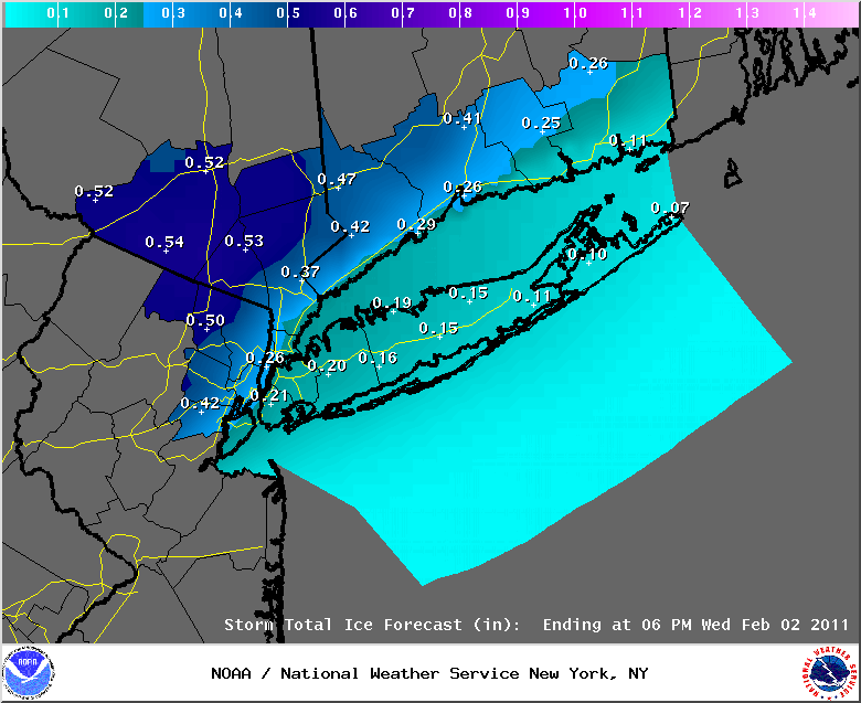
February 2nd, 2011---: Morning Update | Ice Storm Warning now in effect for the NYC/NJ metro with up to 6/10" of ice accumulation possible! Stay OFF the roads this morning unless absolutely necessary. The Ice Storm Warning is in effect until 9am EST but keep in mind, the roads will be a mess today period so if there was ever a day to take a personal day, today is the day. The first wave of freezing rain moved through between 2-3am, and another batch of heavy freezing rain will move into the metro around 5am, causing even more ice to accumulate on area roads and sidewalks. Any left over precip is forecast to change to all rain by 9am, but the damage will already be done. Below is the latest NWS forecast ice accumulation totals graphics for NYC, Long Island, northeast NJ, southern CT and the Lower Hudson Valley.
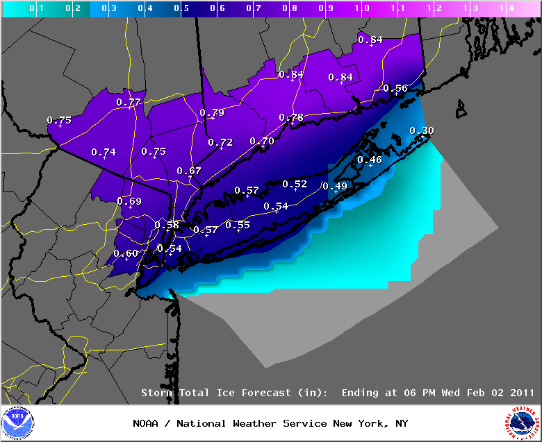
February 1st, 2011---: Evening Update | Quick update in regards to the winter storm that is affect pretty much the entire eastern half of the US! For the NYC metro we're still on target for receiving up to 1/4" of ice late tonight and into the morning commute tomorrow. A Freezing Rain Advisory is in effect for our area. Not much in the way of snow for us this time around, but the extended period of freezing rain is nothing to mess with. If you have plans to be out on the roads later tonight and early tomorrow morning, change those plans if you can. The roads in and around the NYC/NJ metro will be extremely treacherous. Once the change over to rain is complete, which right now looks to occur sometime Wednesday morning, we'll be in better shape as far as the ice goes, but make no mistake, the roads will still be pretty slippery. For areas north of the city in the Lower Hudson Valley, an Ice Storm Warning is in effect for up to 1/2" of ice accumulations. Further north around Albany the precip will remain all snow and those locations could see up to a foot of snow or more! All in all this is an incredible storm without a doubt. Blizzard warnings are in effect in 8 states! For the latest info straight from the NWS regarding the warnings that are in effect for the area, click here. Hang tight everyone and stay safe!! Image Below: The latest ice accumulation forecast issued by the National Weather Service at 9:45pm. Looks like parts of northeast NJ could be looking at close to 1/2" of ice by morning, and the NYC metro is still in that 1/4" range.
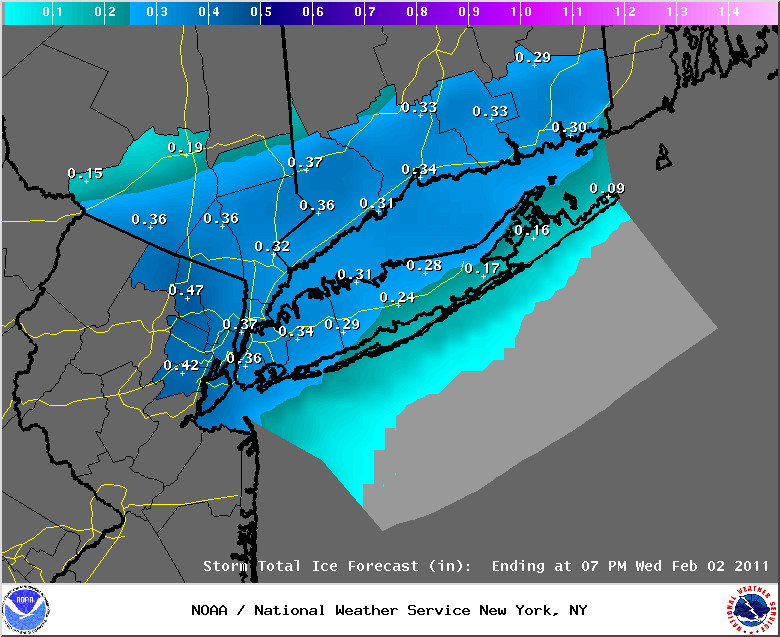
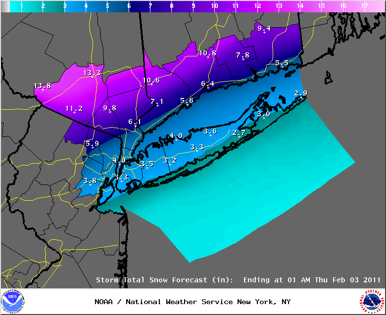
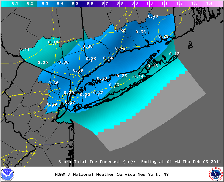
February 1st, 2011---: A serious weather situation may be setting up for the NYC/NJ metro, Long Island, southern Connecticut and parts of the Lower Hudson Valley. While we're not going to see the big time snow fall totals this time around (like many other cities and states will be) we'll have some potentially serious problems of our own to contend with. The NWS is forecasting up to 1/3-1/2" of ice accumulation in spots around NYC later tonight, and into the day on Wednesday. Keep in mind, this will be on top of 4-6" of slushy snow that is forecast to accumulate during the day today and into the evening. A very complex storm system is affecting many states today and this storm is moving east right towards the NYC metro. Since this storm is moving at us from the west this time, warmer air aloft is expected to be pulled up from the south, and into coastal locations later tonight and into Wednesday. Temperatures at the surface however will remain close to freezing and therefore we are expecting what could be an extended period of freezing rain and ice later tonight and into the morning on Wednesday. How long the period of freezing rain/ice lasts will depend on how fast the coastal front can move up from the south and pass through our area to the north. There are some indications that this coastal front might not clear the area too fast, and if that occurs, then the period of icing would be longer. If it clears the area faster than expected, then the period of freezing rain/ice would be less. Regardless though, make no mistake, there will most likely be at least a few hours of freezing rain later tonight and this will most likely coincide with the morning rush hour tomorrow. If you have plans to be out driving tomorrow morning, I would seriously consider alternate means of travel as the road conditions are expected to be extremely treacherous. The National Weather Service has issued a Winter Storm Warning for the NYC metro and surrounding and you can read the details of that warning by clicking here, and scrolling down until you see your location listed in the header. Again, the exact details of this storm will remain a bit foggy since there are many factors coming into play here with a mixed bag of precipitation expected. Heed the warnings and if you can, stay off the roads later tonight and tomorrow morning. Top Image: The current NWS snow fall totals forecast issued at 7am this morning. Middle Image: The current ice accumulation forecast issued by the NWS at 7am this morning. These totals have gone up from last night and parts of the area could be looking at almost 1/2" of ice accumulations on top of a slushy 4-6" of snow. Bottom Image: The HPC's (Hydrometeorological Prediction Center) graphics showing what areas have the highest likely hood of experiencing at least 1/4" of ice accumulation. NYC is in the "moderate" zone. I will have another brief update this evening.
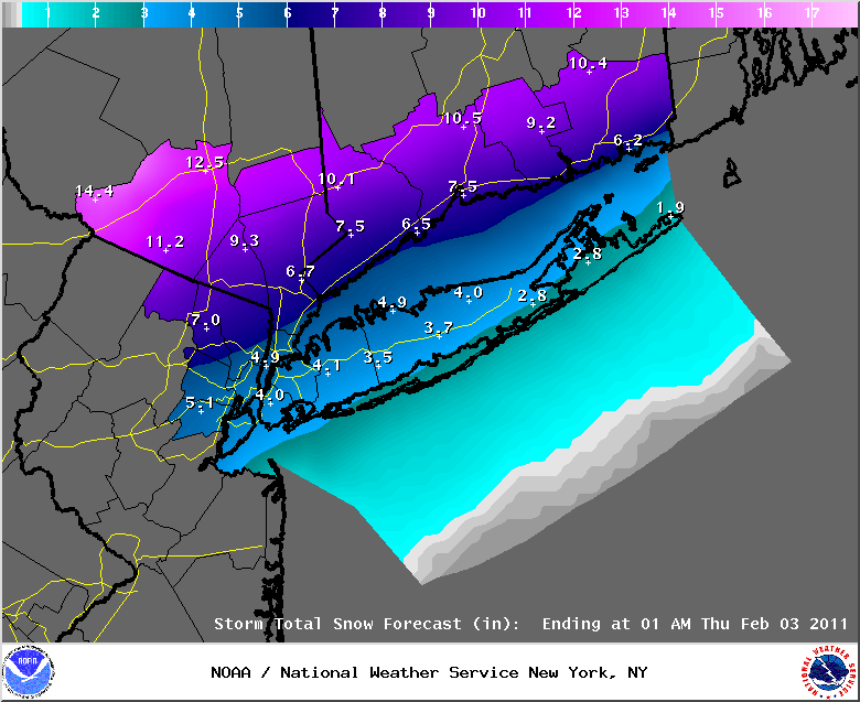
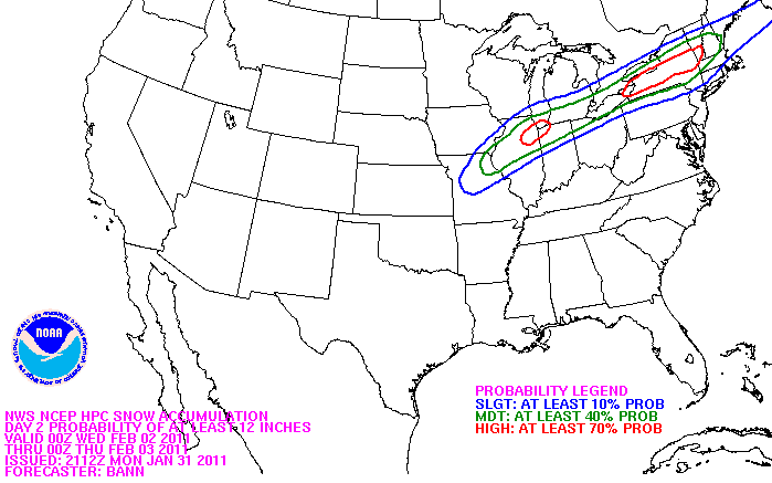
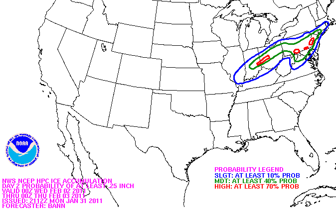
January 31st, 2011---: Evening Update | A huge winter storm is currently taking aim at many states, from the mid west, to the northeast! This storm is huge and will be affecting millions of people in many states. But, I'll concentrate on the northeast part of the country since this is where I am located. Everything is still looking on target for snow beginning in the NYC metro late tonight and into the morning hours Tuesday. Snow should mix with some sleet during the afternoon with total accumulations in NYC and surrounding coastal locations somewhere in the order of 2-5 inches. For areas north of NYC, they could be looking at totals around 6 inches or so. Then the main event comes in late Tuesday and overnight into Wednesday. For the NYC metro we could be looking at an extended period of ice & freezing rain which will wreak havoc on the morning commute Wednesday morning. If you have plans to be driving Wednesday morning, seriously consider alternate means of travel. Right now the forecast calls for about 1/4" of ice accumulation in and around the NYC area but the exact amount is almost impossible to pinpoint. Could be more or less depending on how fast we transition from snow and sleet, to just plain rain. Either way, it's looking very likely we'll see a period of freezing rain so plan for that. By Wednesday mid day we should, note I said "should" be all rain, but again...details are sketchy so to sum it up, plan for one heck of a mess around the NYC metro. Now, for locations north of us in the Lower Hudson Valley and Connecticut, much less mixing should occur there so those areas could see significant snow fall totals when all is said and done. For the latest watch and warning text direct from the National Weather Service, click here and scroll down until you see your location listed in the header. Below are some graphics issued by the NWS this evening. Top Image: Current snow fall totals forecast for the NYC metro and surrounding. 2nd Image From Top: Forecast Ice accumulation totals for the NYC metro and surrounding. 3rd Image: HPC forecast graphics showing which areas have the highest likely hood of seeing at least 12" of snow. Bottom Image: HPC forecast graphics showing what areas have the highest likely hood of seeing at least 1/4" of freezing rain and ice accumulations. I'll have another update tomorrow.
January 31st, 2011---: Our next winter storm will feature a whole mixed bag of goodies for the NYC/NJ metro including snow, sleet, freezing rain, and just plain rain. This is a very complex forecast due to there being many different forms of precipitation falling, but here's how it's looking right now for the NYC area and surrounding locations. Things will start to go down hill later tonight as some light snow moves into the area. Tuesday will feature on and off light snow, and at times some sleet will mix in as well. The NYC area is under a Winter Storm Watch at this time, but the current thinking is that less than 6 inches of snow will fall here, before a change over occurs. 2-5" seems more likely to fall over the course of the day on Tuesday. Then on Tuesday night, the snow/sleet is expected to change over to freezing rain and ice for a period of time into Wednesday morning. This will wreak havoc on the Wednesday morning commute as we could see up to 1/4" of ice accumulation, on top of the slushy few inches of snow that fell prior. This will make for some very dangerous driving conditions so please plan ahead for this and consider opting out of driving to work on Wednesday morning if you don't absolutely have to. The freezing rain and ice is expected to change over to just plain rain by mid day or so on Wednesday but again, details in the exact location of the freezing rain/snow line are sketchy at best so it's possible we could see a longer duration of freezing rain, or a shorter one. Either way, it's looking like a good bet that there will at least be a few hours of icing occurring in and around the NYC metro before a change over to rain occurs. Now, as far as locations north of us away from the coast, it's these areas that will see the bigger snow fall totals, and the more serious icing. Areas in the Lower Hudson Valley could be looking at 12"+ of snow fall and up to 1/2" of icing over the course of Tuesday and Wednesday. Areas in Connecticut could be looking at the same. Points even further north around Albany, Glens Falls, Vermont, New Hampshire, etc.. will most likely be looking at an all snow event where big time snows could pile up. As you can see, this storm will have a little bit of everything. I'll have another update later this evening...
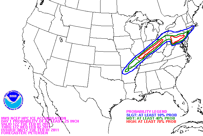
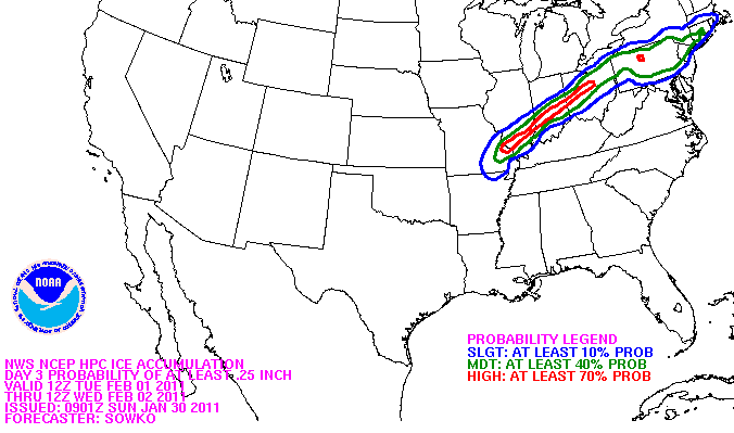
January 30th, 2011---: Ok, so everyone has been asking, "what's going to happen with this next storm!?". The answer is quite complex as it always is but here's how it's looking right now. At least as far as the NYC metro is concerned, we should see snow begin to move in tomorrow night and last throughout the day on Tuesday. There could be an advisory level snow fall during that time, meaning we could see 2-4 inches of accumulation here before a change to more mixed precip begins to move into coastal locations later on Tuesday night. It's at this point that things become more tricky with the forecast. Right now it looks like the NYC area will see a period of freezing rain before a change over to all rain occurs sometime Wednesday morning. This storm is coming at us from the west, instead of up from the south like a true coastal storm so we will be more on the warm side of things here in the NYC metro due to a southerly, on shore flow. Most folks thing ok good, rain and not snow for a change but here's the potential problem with that. We have a TON of snow on the ground here around the NYC/NJ metro and if we get a full on rain storm this will cause rapid melting of the snow pack and in turn, could spell major flooding problems for parts of the area. I know this well as back in March of 1994 we had a similar set up and saw rapid melting of snow and ice around the area. My basement was flooded with water almost 6 inches deep! I'm not saying that we'll see a repeat of this, but it's possible. Now as far as locations north and west of NYC, in the Lower Hudson Valley, Connecticut and parts of MA..these areas could see prolonged periods of icing/freezing rain. They could be facing a potentially serious situation up there. Locations further north could be looking at significant snow fall accumulations. Still details to be ironed out but for now let's just say Tuesday through Thursday is looking to be a mess! Image Below: The current HPC's (Hydrometeorological Prediction Center) ice accumulations Probabilities map showing what areas have the highest/lowest chances of seeing at least 1/4 inch of accumulating ice. Notice that for now, many areas just north of the NYC metro are in the "moderate" risk. Stay tuned. I will post another brief update on my blog later tonight.
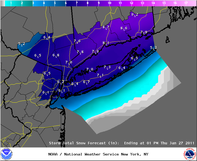
January 27th, 2011---: Snow fall totals from around the tri-state area from this latest winter blitz!
CONNECTICUT
...FAIRFIELD COUNTY...
DARIEN 18.0 800 AM 1/27 CT DOT
NEW CANAAN 18.0 530 AM 1/27 TRAINED SPOTTER
NORWALK 18.0 1025 AM 1/27 PUBLIC
WILTON 17.3 1115 AM 1/27 PUBLIC
WEST NORWALK 17.0 110 AM 1/27 PUBLIC
WESTON 16.5 800 AM 1/27 TRAINED SPOTTER
GREENWICH 16.0 720 AM 1/27 DPW
WESTPORT 14.8 830 AM 1/27 SKYWARN SPOTTER
NEWTOWN 14.2 900 AM 1/27 PUBLIC
RIDGEFIELD 14.0 600 AM 1/27 PUBLIC
BRIDGEPORT 13.0 600 AM 1/27 COOP OBSERVER
SHELTON 13.0 215 AM 1/27 SKYWARN SPOTTER
DANBURY 13.0 215 AM 1/27 SKYWARN SPOTTER
3 SSE BROOKFIELD 9.5 700 AM 1/27 COCORAHS
...MIDDLESEX COUNTY...
1 NE EAST HAMPTON 16.0 700 AM 1/27 COCORAHS
MIDDLETOWN 15.0 535 AM 1/27 PUBLIC
HADDAM 15.0 1000 AM 1/27 CT DOT
OLD SAYBROOK 15.0 1000 AM 1/27 CT DOT
1 S PORTLAND 13.0 800 AM 1/27 COCORAHS
...NEW HAVEN COUNTY...
NORTH HAVEN 18.5 605 AM 1/27 PUBLIC
SEYMOUR 16.5 800 AM 1/27 PUBLIC
MILFORD 16.3 800 AM 1/27 CT DOT
NEW HAVEN 16.0 800 AM 1/27 CT DOT
PROSPECT 16.0 1217 PM 1/27 TRAINED SPOTTER
3 ESE MILFORD 15.4 1235 PM 1/27 COCORAHS
BRANFORD 15.0 554 AM 1/27 PUBLIC
NAUGATUCK 13.0 1020 AM 1/27 PUBLIC
MERIDEN 13.0 800 AM 1/27 CT DOT
SOUTHBURY 12.5 440 AM 1/27 SKYWARN SPOTTER
WATERBURY 11.5 600 AM 1/27 CT DOT
BEACON FALLS 10.5 800 AM 1/27 CT DOT
...NEW LONDON COUNTY...
LISBON 17.5 702 AM 1/27 TRAINED SPOTTER
COLCHESTER 16.0 800 AM 1/27 CT DOT
GROTON 13.8 1000 AM 1/27 CT DOT
NORTH FRANKLIN 13.5 625 AM 1/27 PUBLIC
GALES FERRY 12.5 717 AM 1/27 SKYWARN SPOTTER
3 WNW OAKDALE 12.0 700 AM 1/27 COCORAHS
NORWICH 10.5 800 AM 1/27 CT DOT
LEDYARD CENTER 10.0 900 AM 1/27 PUBLIC
NEW JERSEY
...BERGEN COUNTY...
GARFIELD 16.6 1038 AM 1/27 PUBLIC
NORTH ARLINGTON 16.5 700 AM 1/27 SKYWARN SPOTTER
EAST RUTHERFORD 15.5 400 AM 1/27 NJ DOT
LODI 15.0 1119 AM 1/27 PUBLIC
1 W TENAFLY 14.6 700 AM 1/27 COCORAHS
PARAMUS 12.5 400 AM 1/27 NJ DOT
ORADELL 12.2 1015 AM 1/27 TRAINED SPOTTER
1 E SADDLE BROOK TWP 12.1 600 AM 1/27 COCORAHS
SADDLE BROOK 12.1 700 AM 1/27 COCORHAS
RIDGEWOOD 11.7 700 AM 1/27 SKYWARN SPOTTER
RIVERVALE 11.5 600 AM 1/27 PUBLIC
HARRINGTON PARK 11.0 700 AM 1/27 SKYWARN SPOTTER
1 SSE GLEN ROCK 10.9 715 AM 1/27 COCORAHS
WASHINGTON TOWNSHIP 9.0 700 AM 1/27 SKYWARN SPOTTER
1 SSE OAKLAND 9.0 815 AM 1/27 COCORAHS
MAHWAH 8.9 900 AM 1/27 SKYWARN SPOTTER
WNW OAKLAND 7.9 700 AM 1/27 COCORAHS
...ESSEX COUNTY...
NEWARK AIRPORT 18.9 615 AM 1/27 FAA CONTRACT OBSERVER
BLOOMFIELD 16.5 340 AM 1/27 PUBLIC
WEST ORANGE 14.2 330 AM 1/27 PUBLIC
CEDAR GROVE 13.2 410 AM 1/27 PUBLIC
...HUDSON COUNTY...
N HARRISON 17.0 600 AM 1/27 COOP OBSERVER
JERSEY CITY 16.0 400 AM 1/27 NJ DOT
HARRISON 15.0 400 AM 1/27 TRAINED SPOTTER
...PASSAIC COUNTY...
CLIFTON 19.0 400 AM 1/27 NJ DOT
WAYNE 10.5 600 AM 1/27 TRAINED SPOTTER
HAWTHORNE 10.1 825 AM 1/27 SKYWARN SPOTTER
1 SSE HAWTHORNE 10.1 700 AM 1/27 COCORAHS
1 SSW WAYNE TWP 9.3 700 AM 1/27 COCORAHS
RINGWOOD 9.2 700 AM 1/27 SKYWARN SPOTTER
1 S WANAQUE 7.5 800 AM 1/27 COCORAHS
3 NE WEST MILFORD TW 6.3 630 AM 1/27 COCORAHS
...UNION COUNTY...
RAHWAY 19.5 1030 AM 1/27 PUBLIC
ROSELLE 17.9 430 AM 1/27 TRAINED SPOTTER
ELIZABETH 17.7 700 AM 1/27 TRAINED SPOTTER
UNION 17.0 400 AM 1/27 NJ DOT
1 NNW WESTFIELD 16.7 700 AM 1/27 COCORAHS
WESTFIELD 13.0 650 AM 1/27 TRAINED SPOTTER
CLARK 12.0 400 AM 1/27 NJ DOT
NEW YORK
...BRONX COUNTY...
PELHAM PARKWAY HOUSE 18.0 400 AM 1/27 TRAINED SPOTTER
PARKCHESTER 16.3 630 AM 1/27 COOP OBSERVER
BRONX 14.7 620 AM 1/27 PUBLIC - BRONX ZOO
BEDFORD PARK 13.1 1230 AM 1/27 PUBLIC
...KINGS COUNTY...
MARINE PARK 17.5 800 AM 1/27 PUBLIC
...KINGS (BROOKLYN) COUNTY...
SHEEPSHEAD BAY 13.0 600 AM 1/27 TRAINED SPOTTER
...NASSAU COUNTY...
FLORAL PARK 17.5 900 AM 1/27 SKYWARN SPOTTER
WOODMERE 16.4 1000 AM 1/27 PUBLIC
GARDEN CITY SOUTH 16.0 800 AM 1/27 SKYWARN SPOTTER
LONG BEACH 15.9 600 AM 1/27 TRAINED SPOTTER
BETHPAGE 15.5 600 AM 1/27 TRAINED SPOTTER
PLAINVIEW 15.0 500 AM 1/27 SKYWARN SPOTTER
GARDEN CITY 14.8 600 AM 1/27 PUBLIC
VALLEY STREAM 14.2 900 AM 1/27 PUBLIC
MERRICK 14.2 700 AM 1/27 SKYWARN SPOTTER
SYOSSET 14.0 400 AM 1/27 NWS EMPLOYEE
LEVITTOWN 14.0 545 AM 1/27 PUBLIC
NORTH MASSAPEQUA 12.5 915 AM 1/27 NWS EMPLOYEE
OCEANSIDE 12.0 600 AM 1/27 TRAINED SPOTTER
MASSAPEQUA 11.0 630 AM 1/27 SKYWARN SPOTTER
BALDWIN HARBOR 9.2 600 AM 1/27 TRAINED SPOTTER
...NEW YORK COUNTY...
CENTRAL PARK 19.0 630 AM 1/27 CENTRAL PARK ZOO
...ORANGE COUNTY...
HARRIMAN 9.5 600 AM 1/27 SKYWARN SPOTTER
2 SE MONROE 8.3 800 AM 1/27 COCORAHS
NEW WINDSOR 7.2 630 AM 1/27 PUBLIC
MOUNTAIN LODGE PARK 7.0 1035 AM 1/27 SKYWARN SPOTTER
SOUTH BLOOMING GROVE 6.5 927 AM 1/27 SKYWARN SPOTTER
1 NNW CORNWALL ON HU 6.5 700 AM 1/27 COCORAHS
MIDDLETOWN 5.4 245 AM 1/27 PUBLIC
GOSHEN 5.0 647 AM 1/27 SYWARN SPOTTER
MOUNT HOPE 4.3 830 AM 1/27 PUBLIC
PORT JERVIS 2.6 700 AM 1/27 COOP OBSERVER
NEWBURGH 2.0 820 AM 1/27 SYKWARN SPOTTER
...PUTNAM COUNTY...
MAHOPAC 11.0 900 AM 1/27 SKYWARN SPOTTER
4 ESE BEACON 8.5 700 AM 1/27 COCORAHS
8 NE COLD SPRINGS 8.0 700 AM 1/27 COCORAHS
...QUEENS COUNTY...
WHITESTONE 18.5 700 AM 1/27 PUBLIC
NYC/LA GUARDIA 17.3 615 AM 1/27 FAA CONTRACT OBSERVER
BAYSIDE 17.3 800 AM 1/27 SKYWARN SPOTTER
FRESH MEADOWS 16.2 230 AM 1/27 PUBLIC
WOODSIDE 16.0 600 AM 1/27 TRAINED SPOTTER
HOWARD BEACH 16.0 700 AM 1/27 SKYWARN SPOTTER
NYC/JFK AIRPORT 10.3 615 AM 1/27 ASOS
...RICHMOND COUNTY...
GREAT KILLS 20.0 1000 AM 1/27 PUBLIC
ELTINGVILLE 18.0 800 AM 1/27 PUBLIC
STATEN ISLAND 15.0 500 AM 1/27 SKYWARN SPOTTER
...ROCKLAND COUNTY...
STONY POINT 7.6 624 AM 1/27 TRAINED SPOTTER
...SUFFOLK COUNTY...
HUNTINGTON STATION 18.3 248 PM 1/27 OBSERVER
EAST NORTHPORT 17.5 110 PM 1/27 PUBLIC
NORTHPORT 16.5 600 AM 1/27 PUBLIC
CENTERPORT 16.5 600 AM 1/27 COOP OBSERVER
MEDFORD 15.4 700 AM 1/27 SKYWARN SPOTTER
MELVILLE 15.0 800 AM 1/27 TRAINED SPOTTER
SMITHTOWN 14.5 1000 AM 1/27 TRAINED SPOTTER
PORT JEFFERSON 14.0 630 AM 1/27 PUBLIC
ISLIP AIRPORT 13.7 700 AM 1/27 FAA CONTRACT OBSERVER
SHOREHAM 13.7 625 AM 1/27 TRAINED SPOTTER
NORTH BABYLON 13.5 615 AM 1/27 PUBLIC
UPTON 13.3 700 AM 1/27 NWS OFFICE
STONY BROOK 13.1 1100 AM 1/27 TRAINED SPOTTER
MOUNT SINAI 12.4 600 AM 1/27 PUBLIC
SOUND BEACH 12.1 630 AM 1/27 PUBLIC
SAYVILLE 12.0 300 PM 1/27 PUBLIC
PATCHOGUE 12.0 620 AM 1/27 NWS EMPLOYEE
CENTEREACH 12.0 730 AM 1/27 NWS EMPLOYEE
HOLBROOK 11.3 600 AM 1/27 PUBLIC
BAITING HOLLOW 11.0 100 PM 1/27 PUBLIC
1 SSW JAMESPORT 11.0 900 AM 1/27 COCORAHS
LINDENHURST 10.9 540 AM 1/27 TRAINED SPOTTER
AMITYVILLE 10.5 1050 AM 1/27 PUBLIC
BABYLON 10.3 717 AM 1/27 SKYWARN SPOTTER
RIVERHEAD 9.2 730 AM 1/27 NWS EMPLOYEE
MATTITUCK 8.5 900 AM 1/27 NWS COOP
1 WNW EAST MORICHES 4.5 845 AM 1/27 COCORAHS
...WESTCHESTER COUNTY...
IRVINGTON 20.0 1200 PM 1/27 PUBLIC
BRONXVILLE 19.7 430 AM 1/27 PUBLIC
HARRISON 16.0 610 AM 1/27 PUBLIC
LARCHMONT 15.5 1000 AM 1/27 PUBLIC
ARMONK 14.5 615 AM 1/27 PUBLIC
SCARSDALE 14.2 715 AM 1/27 SKYWARN SPOTTER
BEDFORD 14.1 930 AM 1/27 PUBLIC
MAMARONECK 13.0 700 AM 1/27 SKYWARN SPOTTER
PORT CHESTER 12.6 945 AM 1/27 PUBLIC
MOUNT KISCO 12.0 350 AM 1/27 PUBLIC
YORKTOWN HEIGHTS 10.0 700 AM 1/27 COOP OBSERVER
2 NW SOUTH SALEM 7.2 800 AM 1/27 COCORAHS
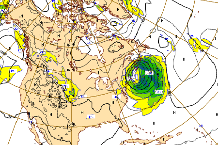
January 27th, 2011---: Holy cow did we get clobbered here in the NYC metro! 19 inches reported in Central Park, Manhattan with 18 inches measured here by me in Rego Park, Queens. Yeah, lol....just a tad bit higher than forecast. Models didn't handle this one all that well. Hey, it's the weather ya know? Either way, what a winter we're having here in the NYC area! Shattering records left and right. Will post snow fall totals later this afternoon, along with photos taken during and after the storm. If you'd like to check out the video and still photo montage I compiled, head over to my "latest storm videos" page. The video starts out with "thundersnow"!
January 26th, 2011---: *6pm Update* The lull is about to end here in the NYC/NJ metro. Thundersnow has been reported at many locations in MD/VA and around the DC area. Snow fall rates of 1-3 inches per hour possible this evening and tonight in the NYC/NJ metro so hunker down and stay inside! Don't be out on the roads if you don't have to. Things should wind down by 2am here in the city. 4 inches so far in Central Park, and here in Queens, NY where I live and we could easily see another 6 or more inches before all is said and done. Live stream still up and running, just click the "live streaming" link on the navigation bar to view the feed! Image Below: Radar animation showing heavy precip moving back into our area from the south.
January 26th, 2011---: *Update* Snow fall totals have been adjusted upward by the NWS due to heavy snow bands setting up over NYC/NJ metro earlier and more intense than expected. The NWS feels that the poor handling by the models is due to the insane amount of convection over the Gulf yesterday evening. Basically to simplify it, that threw a wrench into the mix. Expect a break in the action this afternoon, possibly some sleet/rain, and then a second round of what could be heavy snow later this evening and into the night time hours. Below are the updated snow fall totals from the NWS as of 11am
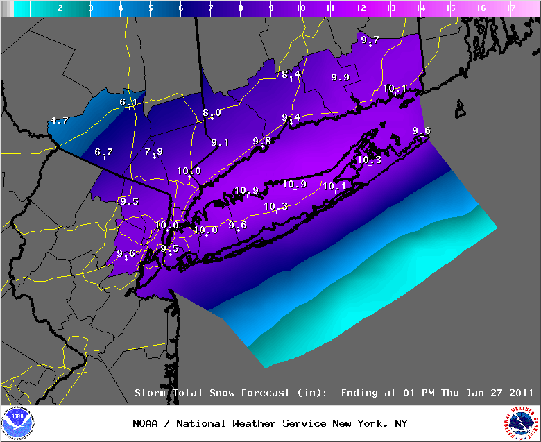
January 26th, 2011---: Morning Update | Winter Storm Warnings have been issued for the entire NYC/NJ metro and the forecast appears to still be in line for between 5 and 7 inches of snow accumulations. There is still some uncertainty however regarding how much sleet, and possibly rain will mix in for a time later this afternoon. Right now it's not looking like they'll be too much mixed precip so my official forecast is for 6-8 inches total. I do think we will see a period of some mixing here at the coast, but this will transition back over to snow it seems prior to the heaviest precip coming in later this afternoon and evening. Because of this likely hood, it shouldn't have too much of an impact on snow fall totals. We will see if this pans out as forecast. This is the weather so getting thrown a curve ball is always a possibility. If something drastically changes with the forecast, I will post it here so be sure to check back later this afternoon to see if any changes have been made. If you are interested in reading the Winter Storm Warning text issued by the NWS, click here and scroll down until you see your location listed in the header. I will be live streaming later this afternoon and evening so be sure to check out my "live streaming" page after 5pm this afternoon to view the live feed!
January 25th, 2011---: *9pm Update* Updated snow fall totals graphics posted below.Looks like the NYC metro is still forecast to be in the 6 inch snow fall range. By the way, I'm planning on live streaming from my static web cam here in Queens, NY beginning tomorrow evening. More on that, and the updated forecast tomorrow morning!
January 25th, 2011---: A Winter Storm Watch is in effect for the NYC metro and surrounding locations. This means that there is a high likely hood of us seeing at least 6 inches of snow out of this storm by the time everything winds down Thursday morning. Here's the tricky part though, here at the coast at least there is also a high likely hood of the snow mixing with, and for a time changing to rain, before a change back to snow occurs later Wednesday evening and into the overnight hours. This obviously complicates the forecast for us as far as snow totals go. If there is less mixing in the NYC metro and other locations near the coast, then we could end up seeing more snow than forecast. More mixing than anticipated and we'll see less. Right now we're looking at right around 6 inches of snow accumulations here in the NYC metro. Locations north of here will most likely see all snow from this coastal storm so it's a bit more clear cut there. There are still some uncertainties in regards to the exact track, but pretty much all the models agree now on a track very near the 70/40 benchmark later Wednesday night and into Thursday morning. Normally this would mean an all snow event for us here in NYC, but it does appear that we'll see some warmer air aloft moving into coastal locations and this is what will give us that mixed bag of precipitation for a time. Again, for now at least this change over from snow initially at the onset, to sleet and rain is expected to last just a few hours before our winds shift from the east/northeast, to the north and colder air gets dragged back down into the area, changing the mixed precip back over to snow here at the coast. It's at this time the heaviest precip is forecast to fall (between 7pm Wednesday evening and 4am Thursday morning). So at the time the heaviest precip moves in we *should* be back to all snow at this point, which is why the Winter Storm Watch has been issued. I'll have another update later this evening, stay tuned! Top Left Image: Some light snow moves through my neighborhood this morning, a sign of things to come. Top Right Image: The latest 12z ECMWF forecast showing a track near the benchmark late tomorrow night. Bottom Image: Current snow fall totals forecast issued by the National Weather Service at 1:15pm this afternoon. I will post the updated graphics later this evening.
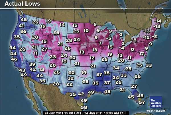
January 24th, 2011---: *UPDATE* It looks like Kennedy Airport, NY tied a record at 7:27am this morning when the temperature dipped to 6 degrees (-14.4C). This ties the previous record set in 2005.
January 24th, 2011---: Afternoon Update | Talk about cold! Today Central Park, NYC dipped down to 9 degrees here this morning, that's -12.7C for you metric folks out there. Here in Rego Park, Queens where I live, my thermometer bottomed out at 7 degrees (-13.8C) just before dawn this morning. I believe this was the coldest morning here in NYC since 2005! See US low temperatures map below. As if the cold wasn't enough, my attention is also on what could be yet another significant winter storm for the Wednesday/Wednesday night and Thursday morning time frame. There is still much uncertainty regarding the track, and how much warm air will work into the region, and how far north this warm air will make it. These are the worst kinds of set up's really since some areas will see plain rain, some will see heavy snow, some areas could see significant ice accumulations, and some areas will see a little bit of everything. Pinpointing where all this will set up is not easy. One thing is for sure, the Thursday morning commute has the potential to be a huge mess! And the slightest shift in the forecast track will have huge implications on snow fall totals, potential icing, and what areas will be most affected. The latest 12z ECMWF is still showing a good whallop for the NYC metro with a track close to, if not over the benchmark, where as the latest 18z NAM is showing more of a glancing blow. It should be noted that the 18z NAM has trended a little west since the 12z run. The latest 12z GFS is, like the ECMWF, showing a track over the 70/40 benchmark, where as the 15z SREF is showing a track similar to the NAM. My gut is telling me right now that we'll see a mixed bag of everything from snow, to rain, possibly some icing, and then perhaps back to snow as the storm pulls away and our winds shift to a more northerly direction. As has been the case several times this winter, things may not come more into focus until tomorrow when we're within 24 hours of the storm. Another very good thing is that according to the NWS, a NOAA Winter Reconnaissance mission will be flown for this system in the Gulf Of Mexico overnight, and all the data that is collected will be ingested and reflected in the 12z model runs tomorrow afternoon. So things should be much more in focus tomorrow. For now at least, it appears that the locations that have the highest chances of seeing more rain/freezing rain than snow from this storm are parts of eastern Long Island, SE Connecticut and Cape Cod. Areas around NYC, SW Connecticut, northern NJ and the Lower Hudson Valley have a better shot at a snow/ice/rain mix. I do believe that there will be some locations that will receive plowable snow from this, it appears that right now the NYC metro will be on the cusp. Once we get that NOAA data ingested later tonight we should be in better shape as far as getting a clearer picture of all this. So stay tuned! Image Below: US low temperatures this morning
January 23rd, 2011---: The northeast is under the gun once again during the middle of this upcoming week for what could be another significant winter storm. All the models agree that there will be a coastal low forming and moving up the coast around the Tuesday-Thursday time frame. And as usual, there is still a good amount of uncertainty in regards to the track of the storm. But this time around it's not looking to be a solid snow event across the board as there will be a fair amount of warmer air moving in aloft, and at the surface due to an onshore flow. This definitely complicates matters as some areas could experience heavy rains, while others could experience heavy snow. As if winter weather forecasting wasn't complex enough right? lol. As I always like to mention, if you're not interested in all the weather geek technical mumbo jumbo, just skip the following and go to the summary at the bottom.
We're just about into the time frame where I can utilize the short term NAM and SREF models, incorporating them into my forecasts, but for the rest of today and tonight I will go with the GFS and ECMWF. Once we're within 84 hours of the storm, I can then include the short term models in with my forecasts. For the past few days the ECMWF (Euro) has been quite consistent regarding the potential track of this storm, and it has been tracking this system near or just northwest of the all important 70/40 benchmark. The GFS over the last several runs has been quite consistent in it's own right too, but it's been keeping this storm well southeast of the 70/40 benchmark. It should be noted however that after checking the GFS ensembles, the control run has been out of sync with the NCEP mean and many of it's members over the past few runs. The NCEP mean as well as the majority of the members are keeping the track closer to the coast. This *could* be a sign that over the coming runs we'll see the GFS fall in line with the ECMWF's way of thinking. Basically to sum up, it's still too early to call. The threat is there for a significant winter storm, but with the GFS and ECMWF at odds right now, and the short term models still not in range it's a tough call. For now the areas that are most at risk of seeing significant snow accumulations are locations inland from the coast, where as locations at or near the coast have the highest likely hood of seeing a rain-snow mix, or just plain rain. Many more changes are to come with this forecast I suspect so for now plan for a mid week mess in some form, and check back tomorrow as I will have another update by the afternoon.
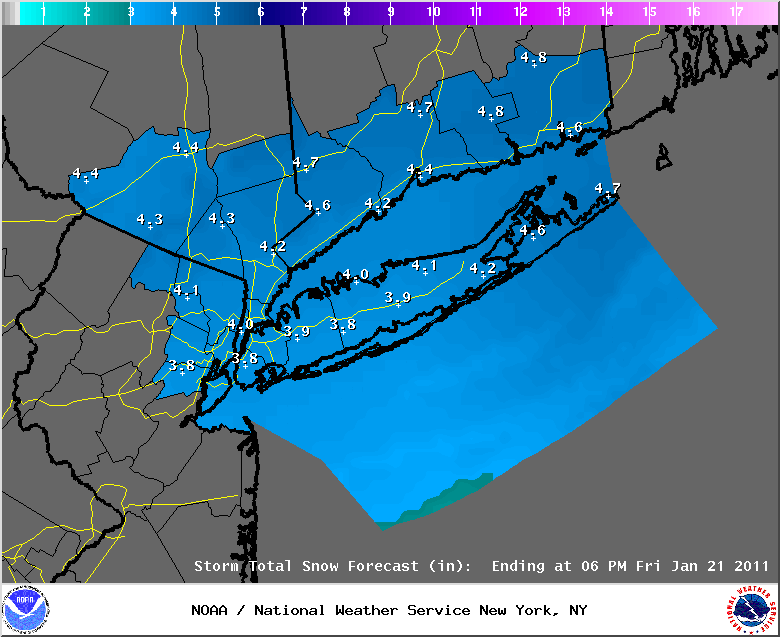
January 21st, 2011---: Looks like my personal forecast was right on target! We received 4 inches of snow here in Queens, NY and the official total in Central Park, Manhattan was 4.2 inches. Below are observations taken from around the tri-state area. My observation of 4.0 inches in Rego Park, Queens is included too. It's still way too early to get into too much detail but.....the models are hinting at what could be a very significant storm for mid next week here in the northeast. Stay tuned.....
CONNECTICUT
...FAIRFIELD COUNTY...
GREENWICH 5.0 800 AM 1/21 SKYWARN SPOTTER
NEW CANAAN 4.6 730 AM 1/21 SKYWARN SPOTTER
BRIDGEPORT 4.5 1100 AM 1/21 COOP OBSERVER
NORWALK 4.5 940 AM 1/21 PUBLIC
DARIEN 4.5 800 AM 1/21 CT DOT
WESTPORT 4.5 906 AM 1/21 SKYWARN SPOTTER
STAMFORD 4.3 810 AM 1/21 PUBLIC
WEST NORWALK 4.0 715 AM 1/21 PUBLIC
WESTON 4.0 1017 AM 1/21 SKYWARN SPOTTER
NEWTOWN 3.8 800 AM 1/21 SKYWARN SPOTTER
RIDGEFIELD 3.5 700 AM 1/21 PUBLIC
DANBURY 3.0 800 AM 1/21 CT DOT
...MIDDLESEX COUNTY...
EAST HAMPTON 3.5 1108 AM 1/21 PUBLIC
OLD SAYBROOK 2.0 800 AM 1/21 CT DOT
...NEW HAVEN COUNTY...
ANSONIA 5.0 935 AM 1/21 MEDIA
EAST HAVEN 5.0 910 AM 1/21 PUBLIC
BRANFORD 4.0 806 AM 1/21 PUBLIC
MILFORD 4.0 800 AM 1/21 CT DOT
WOLCOTT 4.0 900 AM 1/21 MEDIA
NEW HAVEN 4.0 800 AM 1/21 CT DOT
HAMDEN 3.9 900 AM 1/21 MEDIA
BEACON FALLS 3.5 800 AM 1/21 CT DOT
NORTH HAVEN 3.5 934 AM 1/21 PUBLIC
WATERBURY 3.0 800 AM 1/21 CT DOT
SOUTHBURY 2.0 600 AM 1/21 CT DOT
MERIDEN 2.0 800 AM 1/21 CT DOT
...NEW LONDON COUNTY...
LISBON 3.8 1103 AM 1/21 SKYWARN SPOTTER
GALES FERRY 3.5 949 AM 1/21 SKYWARN SPOTTER
OLD LYME 2.5 900 AM 1/21 PUBLIC
NORWICH 2.3 800 AM 1/21 CT DOT
STONINGTON 2.3 930 AM 1/21 SKYWARN SPOTTER
GROTON 2.0 800 AM 1/21 CT DOT
COLCHESTER 2.0 800 AM 1/21 CT DOT
NEW JERSEY
...BERGEN COUNTY...
GARFIELD 4.6 807 AM 1/21 SKYWARN SPOTTER
RIDGEWOOD 4.2 700 AM 1/21 SKYWARN SPOTTER
MIDLAND PARK 4.0 919 AM 1/21 COOP OBSERVER
OAKLAND 4.0 700 AM 1/21 PUBLIC
MAHWAH 3.8 810 AM 1/21 SKYWARN SPOTTER
...ESSEX COUNTY...
WEST ORANGE 5.2 700 AM 1/21 PUBLIC
CEDAR GROVE 4.8 740 AM 1/21 PUBLIC
MILLBURN 4.4 700 AM 1/21 PUBLIC
NEWARK AIRPORT 4.4 1100 AM 1/21 FAA CONTRACT OBSERVER
...HUDSON COUNTY...
HARRISON 5.0 813 AM 1/21 SKYWARN SPOTTER
HOBOKEN 4.7 730 AM 1/21 SKYWARN SPOTTER
KEARNY 3.5 800 AM 1/21 PUBLIC
...PASSAIC COUNTY...
CLIFTON 4.5 845 AM 1/21 PUBLIC
HAWTHORNE 4.1 715 AM 1/21 SKYWARN SPOTTER
WAYNE 4.0 702 AM 1/21 SKYWARN SPOTTER
HASKELL 4.0 900 AM 1/21 SKYWARN SPOTTER
WEST MILFORD 3.9 700 AM 1/21 PUBLIC
...UNION COUNTY...
CLARK 3.8 730 AM 1/21 SKYWARN SPOTTER
GARWOOD 3.8 645 AM 1/21 PUBLIC
ELIZABETH 3.8 800 AM 1/21 SKYWARN SPOTTER
WESTFIELD 3.5 700 AM 1/21 PUBLIC
NEW YORK
...BRONX COUNTY...
PELHAM PARKWAY HOUSE 6.0 730 AM 1/21 SKYWARN SPOTTER
BEDFORD PARK 5.7 747 AM 1/21 PUBLIC
BRONX 5.0 745 AM 1/21 BRONX ZOO
...KINGS COUNTY...
MARINE PARK 3.5 730 AM 1/21 PUBLIC
...KINGS (BROOKLYN) COUNTY...
BROOKLYN HEIGHTS 3.4 800 AM 1/21 SKYWARN SPOTTER
SHEEPSHEAD BAY 2.5 700 AM 1/21 SKYWARN SPOTTER
...NASSAU COUNTY...
WOODMERE 4.9 842 AM 1/21 PUBLIC
FLORAL PARK 4.0 830 AM 1/21 SKYWARN SPOTTER
LYNBROOK 4.0 1200 PM 1/21 SKYWARN SPOTTER
LEVITTOWN 3.9 815 AM 1/21 PUBLIC
WANTAGH 3.9 840 AM 1/21 SKYWARN SPOTTER
NEW HYDE PARK 3.6 1000 AM 1/21 SKYWARN SPOTTER
VALLEY STREAM 3.6 800 AM 1/21 SKYWARN SPOTTER
SYOSSET 3.6 857 AM 1/21 NWS EMPLOYEE
MERRICK 3.5 900 AM 1/21 PUBLIC
PLAINVIEW 3.5 820 AM 1/21 SKYWARN SPOTTER
BELLMORE 3.5 830 AM 1/21 SKYWARN SPOTTER
BELLEROSE 3.5 829 AM 1/21 PUBLIC
CARLE PLACE 3.4 800 AM 1/21 SKYWARN SPOTTER
SEAFORD 3.3 930 AM 1/21 SKYWARN SPOTTER
ROCKVILLE CENTRE 3.0 715 AM 1/21 PUBLIC
BALDWIN HARBOR 2.5 630 AM 1/21 SKYWARN SPOTTER
...NEW YORK COUNTY...
CENTRAL PARK 4.2 1006 AM 1/21 CENTRAL PARK ZOO
UPPER WEST SIDE 4.2 900 AM 1/21 SKYWARN SPOTTER
...ORANGE COUNTY...
HARRIMAN 4.0 700 AM 1/21 SKYWARN SPOTTER
MONTGOMERY 4.0 745 AM 1/21 PUBLIC
WARWICK 3.8 920 AM 1/21 SKYWARN SPOTTER
MIDDLETOWN 3.8 1100 AM 1/21 SKYWARN SPOTTER
GOSHEN 3.8 800 AM 1/21 SKYWARN SPOTTER
HAMPTONBURGH 3.7 800 AM 1/21 SKYWARN SPOTTER
PORT JERVIS 3.6 717 AM 1/21 COOP OBSERVER
WASHINGTONVILLE 3.5 1100 AM 1/21 SKYWARN SPOTTER
NEWBURGH 3.5 930 AM 1/21 SKYWARN SPOTTER
TUXEDO PARK 3.5 1100 AM 1/21 PUBLIC
NEW WINDSOR 3.5 1100 AM 1/21 SKYWARN SPOTTER
CORNWALL ON HUDSON 3.4 800 AM 1/21 SKYWARN SPOTTER
...PUTNAM COUNTY...
MAHOPAC 3.5 1000 AM 1/21 PUBLIC
PUTNAM VALLEY 3.5 1120 AM 1/21 PUBLIC
LAKE CARMEL 3.5 751 AM 1/21 PUBLIC
...QUEENS COUNTY...
BAYSIDE 5.0 933 AM 1/21 SKYWARN SPOTTER
ASTORIA 4.5 746 AM 1/21 PUBLIC
NYC/LA GUARDIA 4.1 1100 AM 1/21 FAA CONTRACT OBSERVER
REGO PARK 4.0 800 AM 1/21 SKYWARN SPOTTER
WOODSIDE 4.0 745 AM 1/21 SKYWARN SPOTTER
RICHMOND HILL 4.0 900 AM 1/21 SKYWARN SPOTTER
HOWARD BEACH 4.0 900 AM 1/21 SKYWARN SPOTTER
NYC/JFK AIRPORT 3.9 700 AM 1/21 FAA CONTRACT OBSERVER
...RICHMOND COUNTY...
ELTINGVILLE 3.0 800 AM 1/21 PUBLIC
...ROCKLAND COUNTY...
NYACK 4.0 945 AM 1/21 PUBLIC
STONY POINT 3.0 815 AM 1/21 SKYWARN SPOTTER
...SUFFOLK COUNTY...
SHOREHAM 4.5 900 AM 1/21 SKYWARN SPOTTER
STONY BROOK 4.5 905 AM 1/21 PUBLIC
SMITHTOWN 4.0 815 AM 1/21 SKYWARN SPOTTER
EAST NORTHPORT 4.0 930 AM 1/21 SKYWARN SPOTTER
DIX HILLS 4.0 800 AM 1/21 PUBLIC
CENTEREACH 4.0 730 AM 1/21 PUBLIC
EAST SETAUKET 4.0 830 AM 1/21 PUBLIC
ROCKY POINT 4.0 1016 AM 1/21 SKYWARN SPOTTER
MOUNT SINAI 3.8 1000 AM 1/21 COOP OBSERVER
PORT JEFFERSON 3.8 830 AM 1/21 PUBLIC
NORTH BABYLON 3.8 842 AM 1/21 PUBLIC
RONKONKOMA 3.6 916 AM 1/21 NWS EMPLOYEE
SOUND BEACH 3.6 1030 AM 1/21 PUBLIC
ISLIP 3.5 946 AM 1/21 PUBLIC
MELVILLE 3.5 830 AM 1/21 SKYWARN SPOTTER
UPTON 3.4 1000 AM 1/21 NWS OFFICE
ISLIP AIRPORT 3.3 700 AM 1/21 FAA CONTRACT OBSERVER
BAY SHORE 3.0 830 AM 1/21 PUBLIC
HOLBROOK 3.0 730 AM 1/21 PUBLIC
MEDFORD 2.9 800 AM 1/21 SKYWARN SPOTTER
LINDENHURST 2.8 751 AM 1/21 SKYWARN SPOTTER
RIVERHEAD 2.8 902 AM 1/21 NWS EMPLOYEE
SAYVILLE 2.6 700 AM 1/21 NWS EMPLOYEE
PATCHOGUE 2.5 1100 AM 1/21 NWS EMPLOYEE
JAMESPORT 2.4 955 AM 1/21 PUBLIC
MATTITUCK 1.9 1048 AM 1/21 PUBLIC
SHIRLEY 1.3 822 AM 1/21 SKYWARN SPOTTER
...WESTCHESTER COUNTY...
ARMONK 5.0 815 AM 1/21 PUBLIC
RYE 4.6 845 AM 1/21 PUBLIC
WHITE PLAINS 4.6 715 AM 1/21 PUBLIC
NORTH WHITE PLAINS 4.5 730 AM 1/21 COCORHAS
MAMARONECK 4.5 800 AM 1/21 PUBLIC
SOMERS 4.3 900 AM 1/21 PUBLIC
YONKERS 4.2 830 AM 1/21 SKYWARN SPOTTER
HARRISON 4.0 830 AM 1/21 PUBLIC
MOUNT VERNON 4.0 1000 AM 1/21 PUBLIC
SCARSDALE 3.9 800 AM 1/21 SKYWARN SPOTTER
NEW ROCHELLE 3.5 845 AM 1/21 PUBLIC
YORKTOWN HEIGHTS 3.5 852 AM 1/21 SKYWARN SPOTTER
January 20th, 2011---: Quick update here this afternoon in regards to our upcoming snow event. It's not going to be a major storm by any means, but timing wise this will still be quite a nuisance since it's looking like it will affect tomorrow mornings rush hour. After taking a look at the latest 12z model data and using a blend of the GFS and NAM precip forecasts my thinking is a general 4-6 inches of snow for the NYC/NJ metro, Lower Hudson Valley and Connecticut. The GFS is putting out around .25 inches of liquid precip, the NAM about .50. With snow/liquid ratios around 12:1 a 4 to 6 inch snow fall looks like a good bet. Which is why the NWS has issued a Winter Weather Advisory for the entire area. To read the details of this advisory, click here and scroll down until you see your location listed. This will also be a quick hitting system too so all snow should be out of the area by noon tomorrow. After that, get ready for a serious arctic blast! Temperatures this weekend will be quite frigid with lows in the lower teens and single digits! More on that later. Below is the latest snow fall totals forecast issued by the National Weather Service this afternoon.
January 19th, 2011---: Here we go yet again! Snow is once again in the forecast for the NYC metro starting tomorrow night, and continuing into the day on Friday. But it's not looking to be a full on snow storm at this time even though the forecast models are showing a track near the 70/40 benchmark. The reason being that this storm will be a relatively fast mover, a quick hitter as they say. This storm is also not currently forecast to be very intense either as it passes off shore, it will be in the process of deepening, but it's not looking like it will be in time to give us a good hit of snow and wind. This could change of course, but for now it's looking like a general 3 to 6 inch snow fall for the NYC metro. Still enough to be a nuisance for sure, but it's not looking like a major storm right now. Check back in tomorrow though as things can and do change in the world of the weather. Below Left: Today's 12z (7am) GFS model run showing our coastal storm tracking near the benchmark on Friday morning. Below Right: Today's 12z NAM showing a similar low track passing near the benchmark on Friday morning.
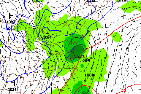
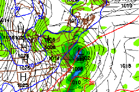
January 18th, 2011---: Afternoon Update | The chilly rains continue here in the NYC area this afternoon, but earlier this morning we had a good bout of freezing rain that coated all of the trees and power lines with about 1/4 inch of ice! Needless to say, travel was very difficult and it's still not a walk in the park even though the freezing rain has now fully changed over to just plain rain. I've posted some photos of the ice from earlier today in the "New Photos" section of my photo gallery. Check them out!
January 18th, 2011---: Freezing rain is finally beginning to subside here in the NYC metro. This has made for an extremely difficult and dangerous morning commute to say the least! However, the freezing rain is forecast to turn into just a plain cold rain here along the coast this afternoon, but until then if you have plans to be out and about, I'd consider putting off those plans until later this afternoon. The evening rush hour here in the city appears right now to just be a wet one, but there will still be many slippery spots so keep both hands on the wheel! Below left is a winter weather radar animation showing the freezing rain and snow line heading north. Don't be fooled though, we are still experiencing a bit of freezing rain here in the city as of 9:30am. Below right is a picture I took right out in front of my house of an ice encrusted tree branch. More pictures will be posted later this afternoon!
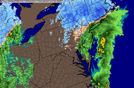
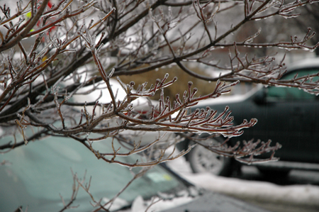
January 17th, 2011---: Evening Update | Everything still looks on target for what could be a rather significant freezing rain and icing event for locations north and west of NYC tomorrow. For NYC, we should begin as a mix of snow and sleet later on tonight and could see an inch or two of accumulation by the morning rush hour. After that, we should see a brief bout of freezing rain here before a change over to all rain occurs during the late morning. No doubt this will create some treacherous driving conditions so be careful while out and about tomorrow morning. A more serious freezing rain and ice event may occur north of us over the Lower Hudson Valley, northern NJ and parts of Connecticut. In these locations the cold air will hang on much longer and along with higher snow totals, those areas may also see some significant ice accumulations. Travel will be extremely difficult tomorrow no matter which way you cut it so stay tuned to the latest forecast, and be very careful if you plan to be out driving tomorrow. For the latest word from the NWS regarding this upcoming storm, Click here.
National Weather Service forecast storm total maps below issued at 3:30pm. Top : Forecast snow totals for the NYC metro and surrounding (ending 1pm tomorrow). Middle: Forecast ice accumulations for the NYC metro and surrounding (ending 1am Wednesday morning). Bottom: Forecast rain totals for the NYC metro and surrounding (ending 7am Wednesday morning).
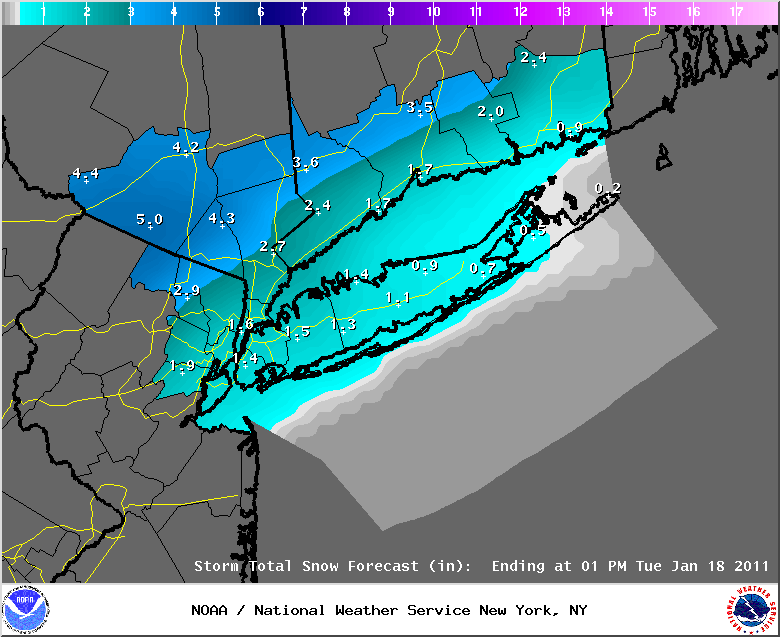
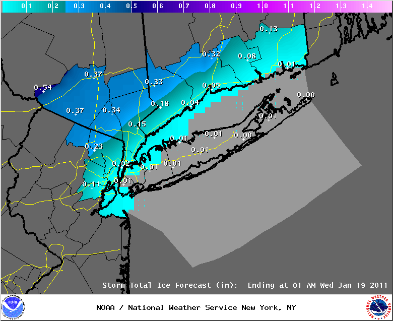
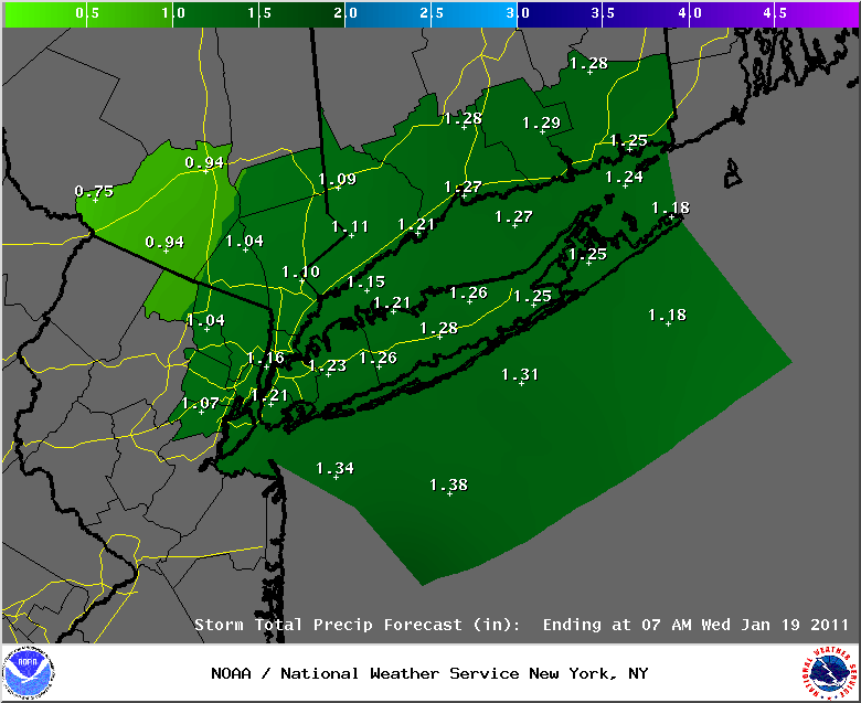
January 17th, 2011---: Morning Update | A Winter Storm Watch is in effect for much of the Lower Hudson Valley of NY, and Connecticut, with Winter Weather Advisories for Northeast NJ. A complex storm system will begin affecting the area tonight, but for us here in NYC and other locations along the coast, it will be a mostly rain event. However, there could be a period of freezing rain here in the city as well, and if that occurs during the morning rush hour watch out as driving conditions will be extremely treacherous! As of right now, all areas should see snow at the onset later on tonight. Here along the coast that snow will change over to sleet and then freezing rain as the warmer air moves in aloft. By later Tuesday morning, it should be just plain rain here in the city, but points north and west may see a prolonged icing event! The official forecast right now is calling for 2 to 6 inches of snow for Northeast NJ, the Lower Hudson Valley and parts of CT before the change over to freezing rain occurs tomorrow morning. Then those locations could be seeing ice accumulations on top of the snow pack, and these icing/freezing rain conditions could last much of the day. Exactly which areas see the worse of the icing will depend on just how far north the warm air pushes. Please stay tuned to the forecast if you plan to be out and about tomorrow as there will be some areas that will be experiencing very dangerous travel conditions. For NYC, as I mentioned above, we could see a period of freezing rain and icing conditions early tomorrow morning which might coincide with the morning rush hour. After that however I think we'll see a change over to just plain rain here, but areas to our north and west do need to watch out. Click here to read the latest National Weather Service warning text which focuses on areas to our north and west that are most in line with seeing some potentially serious and prolonged icing tomorrow. I will have another update later on this afternoon.
January 15th, 2011---: Another cold morning here in the city, but not as cold as it was yesterday morning. After a relatively quiet day on tap for the NYC metro, a clipper system will approach, and then pass well north of our area later this evening. However, this system will be too far north of NYC to bring much more than a dusting (if even that) of snow to the area tonight. So don't expect much in the way of snow, however, a quick dusting of snow is enough to make the roads slick so watch out for that if you're out and about later this evening. After another cold day on Monday our next significant storm will begin affecting the area Monday night, and into Tuesday night. This system is a complex one in terms of precipitation type, but right now for the coast at least it's looking like a mixed bag of precip early, with a change over to rain on Tuesday afternoon. It begins on Monday night in NYC and other coastal locations as snow, then the snow will eventually change over to freezing rain, and then to just plain rain by the late morning/early afternoon. However, depending on how fast the warm air aloft moves in we could see a some what prolonged period of freezing rain in and around the NYC metro, and this would make for some dangerous driving conditions, especially if it's centered around the morning rush hour. The warm air will eventually win out and all locations around NYC will change to rain, but for a time on Tuesday we could see some freezing rain and icing so I'll be keeping an eye on that. Bottom Left Image: This is the 12z (7am) GFS surface temperature forecast showing where this model is forecasting the warm front to be Tuesday morning. Notice how close the freezing line is to NYC. Warmer air is just to the south (temps in the 40s) and below freezing temps to the north (20s and 30s). Bottom Right: The GFS surface temperature forecast for 12 hours later at 0z (7pm) Tuesday evening showing temperatures now above the freezing level in and around the NYC area, as well as much of CT, MA and the Lower Hudson Valley of NY. Another update will be posted tomorrow morning. In the meantime, have a great Saturday!
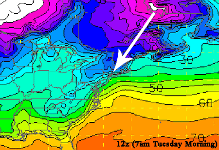
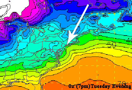
January 14th, 2011---: Bitter cold is griping much of the US today with only south FL escaping the really cold temperatures. Still though, even they are pretty chilly this morning with Miami coming in with a temperature of 55 degrees at 9am! I awoke here this morning in NYC to temperatures in the upper teens, temps like that are not really helping me shake this cold I came down with on Tuesday, but oh well...it is winter after all. Today's high temperatures will struggle to reach the upper 20s here in the city, while areas north and west of NYC will struggle to reach 20 degrees! Tonight, temperatures will once again drop into the upper teens for coastal locations in and around NYC, with single digits for the outlying areas north and west. For Saturday and Saturday night, a clipper system will traverse the area but we're not expecting much out of this system as it moves through our area. We're looking at maybe a quick inch of snow, and that would mostly be confined to areas north of us here in NYC. After that, there could be another significant storm affecting our area on Tuesday, but this time around it's looking to be a mostly rain event for us here in NYC, as well as other locations along the coast. However, we could see some freezing rain at times early Tuesday morning which would make for some difficult and dangerous driving conditions. The current forecast is calling for all areas to start off as snow late Monday night into Tuesday morning. Coastal locations should see a rain/snow mix change over to rain by late morning/early afternoon as warm air noses on in aloft, while the normally colder locations north and west of NYC will have a longer period of snow and freezing rain before they as well change over to rain by the afternoon. Will have more details tomorrow. Image below: US temperatures as of 9am this morning...now that's a cold USA!
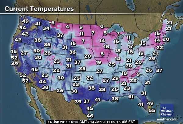
January 12th, 2011---: Below are the unoffical snow fall totals posted by the National Weather Service at 2:30pm. My report of 8.9 inches here in Rego Park, Queens is included!
CONNECTICUT
...FAIRFIELD COUNTY...
NEW FAIRFIELD 28.0 1050 AM 1/12 PUBLIC
NEWTOWN 27.0 840 AM 1/12 SKYWARN SPOTTER
WESTON 24.5 800 AM 1/12 SKYWARN SPOTTER
DANBURY 23.9 1000 AM 1/12 SKYWARN SPOTTER
RIDGEFIELD 22.0 645 AM 1/12 PUBLIC
BROOKFIELD 21.5 730 AM 1/12 COCORAHS
WILTON 18.7 830 AM 1/12 PUBLIC
NEW CANAAN 18.0 915 AM 1/12 SKYWARN SPOTTER
DARIEN 17.5 1100 AM 1/12 CT DOT
WESTPORT 17.4 815 AM 1/12 SKYWARN SPOTTER
SHELTON 17.3 950 AM 1/12 PUBLIC
NORWALK 16.0 934 AM 1/12 PUBLIC
BRIDGEPORT 15.5 850 AM 1/12 NWS COOP
GREENWICH 14.5 800 AM 1/12 SKYWARN SPOTTER
STAMFORD 14.0 800 AM 1/12 SKYWARN SPOTTER
STRATFORD 14.0 930 AM 1/12 PUBLIC
...MIDDLESEX COUNTY...
DEEP RIVER 20.0 1100 AM 1/12 PUBLIC
PORTLAND 16.0 800 AM 1/12 COCORAHS
WESTBROOK 17.3 1035 AM 1/12 PUBLIC
CLINTON 17.0 800 AM 1/12 PUBLIC
OLD SAYBROOK 16.5 1100 AM 1/12 CT DOT
HADDAM 16.0 1100 AM 1/12 CT DOT
...NEW HAVEN COUNTY...
NORTH HAVEN 29.5 1120 AM 1/12 PUBLIC
SOUTHBURY 28.0 1120 AM 1/12 PUBLIC
NORTH BRANFORD 24.0 1240 PM 1/12 PUBLIC
BETHANY 21.0 1220 PM 1/12 SKYWARN SPOTTER
OXFORD 20.0 745 AM 1/12 PUBLIC
SEYMOUR 20.0 1100 AM 1/12 PUBLIC
BRANFORD 19.8 1230 PM 1/12 PUBLIC
WATERBURY 19.0 1100 AM 1/12 CT DOT
NEW HAVEN 19.0 1100 AM 1/12 CT DOT
MERIDEN 18.0 859 AM 1/12 PUBLIC
MILFORD 18.0 1100 AM 1/12 CT DOT
BEACON FALLS 17.3 1100 AM 1/12 CT DOT
GUILFORD 17.0 907 AM 1/12 PUBLIC
MADISON 16.0 1130 AM 1/12 PUBLIC
...NEW LONDON COUNTY...
COLCHESTER 18.5 1100 AM 1/12 CT DOT
NORWICH 16.5 1245 PM 1/12 SKYWARN SPOTTER
MONTVILLE 15.0 1000 AM 1/12 SKYWARN SPOTTER
LISBON 14.5 1155 AM 1/12 SKYWARN SPOTTER
GROTON 14.0 1100 AM 1/12 CT DOT
GALES FERRY 14.0 1000 AM 1/12 SKYWARN SPOTTER
VOLUNTOWN 14.0 1000 AM 1/12 SKYWARN SPOTTER
NORTH FRANKLIN 13.5 945 AM 1/12 PUBLIC
WATERFORD 13.0 1000 AM 1/12 SKYWARN SPOTTER
NEW JERSEY
...BERGEN COUNTY...
EAST RUTHERFORD 12.5 530 AM 1/12 SKYWARN SPOTTER
HACKENSACK 12.1 750 AM 1/12 PUBLIC
GARFIELD 9.8 630 AM 1/12 NJ DOT
RIVERVALE 9.5 800 AM 1/12 PUBLIC
TENAFLY 9.3 630 AM 1/12 COCORAHS
GLEN ROCK 9.2 830 AM 1/12 PUBLIC
SADDLE BROOK 9.0 700 AM 1/12 SKYWARN SPOTTER
RAMSEY 8.8 1000 AM 1/12 COCORAHS
RIDGEWOOD 8.8 700 AM 1/12 SKYWARN SPOTTER
BERGENFIELD 8.8 1045 AM 1/12 SKYWARN SPOTTER
PARAMUS 8.5 800 AM 1/12 NJ DOT
CRESSKILL 8.4 1000 AM 1/12 SKYWARN SPOTTER
MAHWAH 8.2 700 AM 1/12 SKYWARN SPOTTER
HARRINGTON PARK 8.2 1000 AM 1/12 SKYWARN SPOTTER
NORTH ARLINGTON 8.0 830 AM 1/12 SKYWARN SPOTTER
RIVER EDGE 7.8 1000 AM 1/12 SKYWARN SPOTTER
ORADELL 7.4 830 AM 1/12 TRAINED SPOTTER
OAKLAND 7.3 710 AM 1/12 PUBLIC
WASHINGTON TOWNSHIP 6.5 1000 AM 1/12 SKYWARN SPOTTER
WALDWICK 6.3 900 AM 1/12 PUBLIC
...ESSEX COUNTY...
NEWARK AIRPORT 9.1 100 PM 1/12 FAA CONTRACT OBSERVER
CEDAR GROVE 8.2 530 AM 1/12 PUBLIC
MONTCLAIR 8.2 800 AM 1/12 PUBLIC
WEST ORANGE 8.2 430 AM 1/12 PUBLIC
BLOOMFIELD 8.0 1030 AM 1/12 PUBLIC
BELLEVILLE 6.8 300 AM 1/12 SKYWARN SPOTTER
...HUDSON COUNTY...
HOBOKEN 9.1 800 AM 1/12 SKYWARN SPOTTER
JERSEY CITY 8.5 810 AM 1/12 SKYWARN SPOTTER
SECAUCUS 8.2 830 AM 1/12 NJ DOT
HARRISON 8.0 800 AM 1/12 NJ DOT
KEARNY 7.0 800 AM 1/12 PUBLIC
...PASSAIC COUNTY...
CLIFTON 11.0 800 AM 1/12 NJ DOT
HAWTHORNE 8.5 715 AM 1/12 SKYWARN SPOTTER
WEST PATERSON 7.8 1000 AM 1/12 PUBLIC
WEST MILFORD 7.3 630 AM 1/12 COCORAHS
RINGWOOD 7.0 700 AM 1/12 SKYWARN SPOTTER
WAYNE 6.5 700 AM 1/12 SKYWARN SPOTTER
WANAQUE 6.4 800 AM 1/12 COCORAHS
HASKELL 6.0 1000 AM 1/12 SKYWARN SPOTTER
...UNION COUNTY...
ROSELLE 9.2 530 AM 1/12 SKYWARN SPOTTER
GARWOOD 7.5 645 AM 1/12 PUBLIC
UNION 7.5 1015 AM 1/12 SKYWARN SPOTTER
ELIZABETH 7.3 830 AM 1/12 NJ DOT
CLARK 7.3 800 AM 1/12 NJ DOT
CRANFORD 7.0 900 AM 1/12 SKYWARN SPOTTER
NEW YORK
...BRONX COUNTY...
BEDFORD PARK 12.1 525 AM 1/12 PUBLIC
BRONX 9.2 825 AM 1/12 BRONX ZOO
PARKCHESTER 9.0 900 AM 1/12 NWS COOP
PELHAM BAY 8.9 830 AM 1/12 PUBLIC
RIVERDALE 8.5 730 AM 1/12 PUBLIC
...KINGS (BROOKLYN) COUNTY...
BROOKLYN HEIGHTS 8.8 530 AM 1/12 SKYWARN SPOTTER
SHEEPSHEAD BAY 7.0 700 AM 1/12 SKYWARN SPOTTER
MARINE PARK 7.0 700 AM 1/12 PUBLIC
...NASSAU COUNTY...
LEVITTOWN 13.2 625 AM 1/12 PUBLIC
PLAINVIEW 12.6 920 AM 1/12 SKYWARN SPOTTER
OLD BETHPAGE 12.2 840 AM 1/12 SKYWARN SPOTTER
HICKSVILLE 12.0 1200 PM 1/12 SKYWARN SPOTTER
BETHPAGE 11.8 900 AM 1/12 TRAINED SPOTTER
JERICHO 10.8 900 AM 1/12 SKYWARN SPOTTER
NEW HYDE PARK 10.6 855 AM 1/12 SKYWARN SPOTTER
GARDEN CITY 10.2 810 AM 1/12 PUBLIC
BELLMORE 10.1 730 AM 1/12 PUBLIC
GLEN COVE 10.0 1030 AM 1/12 SKYWARN SPOTTER
FLORAL PARK 9.7 526 AM 1/12 PUBLIC
MERRICK 9.5 745 AM 1/12 SKYWARN SPOTTER
WOODMERE 9.2 800 AM 1/12 PUBLIC
VALLEY STREAM 8.3 922 AM 1/12 SKYWARN SPOTTER
CARLE PLACE 8.1 923 AM 1/12 SKYWARN SPOTTER
LIDO BEACH 8.0 1245 PM 1/12 SKYWARN SPOTTER
LYNBROOK 8.0 700 AM 1/12 SKYWARN SPOTTER
SEAFORD 8.0 922 AM 1/12 SKYWARN SPOTTER
EAST HILLS 8.0 900 AM 1/12 PUBLIC
BELLEROSE 8.0 800 AM 1/12 PUBLIC
NORTH MERRICK 8.0 900 AM 1/12 PUBLIC
WEST HEMPSTEAD 8.0 1030 AM 1/12 SKYWARN SPOTTER
ROCKVILLE CENTRE 7.3 715 AM 1/12 PUBLIC
BALDWIN 6.0 700 AM 1/12 SKYWARN SPOTTER
...NEW YORK (MANHATTAN) COUNTY...
UPPER WEST SIDE 9.3 740 AM 1/12 SKYWARN SPOTTER
CENTRAL PARK 9.1 100 PM 1/12 CENTRAL PARK ZOO
WEST SIDE 7.0 1000 AM 1/12 PUBLIC
...ORANGE COUNTY...
TUXEDO PARK 10.0 615 AM 1/12 PUBLIC
CORNWALL-ON-HUDSON 9.5 730 AM 1/12 SKYWARN SPOTTER
VAILS GATE 9.5 920 AM 1/12 SKYWARN SPOTTER
NEW WINDSOR 9.2 1030 AM 1/12 PUBLIC
NEWBURGH 9.1 820 AM 1/12 SKYWARN SPOTTER
MONROE 9.0 927 AM 1/12 SKYWARN SPOTTER
SALISBURY MILLS 7.3 900 AM 1/12 PUBLIC
GOSHEN 7.1 800 AM 1/12 SKYWARN SPOTTER
MIDDLETOWN 7.0 1100 AM 1/12 PUBLIC
GREENWOOD LAKE 7.0 833 AM 1/12 SKYWARN SPOTTER
HARRIMAN 6.8 700 AM 1/12 SKYWARN SPOTTER
PORT JERVIS 6.1 800 AM 1/12 NWS COOP
HAMPTONBURGH 6.0 800 AM 1/12 SKYWARN SPOTTER
WARWICK 6.0 1030 AM 1/12 SKYWARN SPOTTER
...PUTNAM COUNTY...
CARMEL 13.5 855 AM 1/12 SKYWARN SPOTTER
MAHOPAC 11.5 1140 AM 1/12 SKYWARN SPOTTER
...QUEENS COUNTY...
FRESH MEADOWS 12.0 700 AM 1/12 PUBLIC
BAYSIDE 11.0 830 AM 1/12 SKYWARN SPOTTER
MIDDLE VILLAGE 10.1 946 AM 1/12 PUBLIC
REGO PARK 8.9 525 AM 1/12 SKYWARN SPOTTER
ASTORIA 8.1 717 AM 1/12 PUBLIC
RICHMOND HILL 8.0 900 AM 1/12 SKYWARN SPOTTER
WOODSIDE 7.0 600 AM 1/12 SKYWARN SPOTTER
NYC/LA GUARDIA 6.9 100 PM 1/12 FAA CONTRACT OBSERVER
HOWARD BEACH 6.5 600 AM 1/12 SKYWARN SPOTTER
NYC/JFK AIRPORT 6.1 100 PM 1/12 FAA CONTRACT OBSERVER
...RICHMOND COUNTY...
GREAT KILLS 11.2 930 AM 1/12 PUBLIC
ELTINGVILLE 8.0 600 AM 1/12 PUBLIC
STATEN ISLAND 5.8 600 AM 1/12 SKYWARN SPOTTER
...ROCKLAND COUNTY...
NEW CITY 10.0 840 AM 1/12 SKYWARN SPOTTER
NYACK 8.6 740 AM 1/12 PUBLIC
NEW HEMPSTEAD 8.0 845 AM 1/12 PUBLIC
STONY POINT 7.8 745 AM 1/12 SKYWARN SPOTTER
TALLMAN 6.6 1020 AM 1/12 PUBLIC
...SUFFOLK COUNTY...
SELDEN 19.3 1020 AM 1/12 PUBLIC
PORT JEFFERSON 18.0 1115 AM 1/12 PUBLIC
STONY BROOK 17.5 1100 AM 1/12 SKYWARN SPOTTER
CENTEREACH 17.0 1140 AM 1/12 PUBLIC
EAST SETAUKET 16.5 900 AM 1/12 PUBLIC
CENTERPORT 16.2 700 AM 1/12 NWS COOP
MATTITUCK 16.0 1000 AM 1/12 PUBLIC
BRIDGEHAMPTON 16.0 100 PM 1/12 NWS COOP
SMITHTOWN 15.8 1000 AM 1/12 SKYWARN SPOTTER
ISLIP 15.1 100 PM 1/12 FAA CONTRACT OBSERVER
HOLBROOK 15.1 930 AM 1/12 PUBLIC
MILLER PLACE 14.5 1230 PM 1/12 PUBLIC
ISLIP AIRPORT 13.9 700 AM 1/12 FAA CONTRACT OBSERVER
UPTON 13.5 100 PM 1/12 NWS OFFICE
ROCKY POINT 13.1 1150 AM 1/12 SKYWARN SPOTTER
EAST NORTHPORT 13.0 730 AM 1/12 SKYWARN SPOTTER
RONKONKOMA 13.0 945 AM 1/12 NWS EMPLOYEE
DEER PARK 13.0 800 AM 1/12 PUBLIC
SHOREHAM 13.0 1200 PM 1/12 SKYWARN SPOTTER
MOUNT SINAI 12.8 1115 AM 1/12 NWS COOP
NORTH BABYLON 12.5 545 AM 1/12 PUBLIC
PATCHOGUE 12.3 1130 AM 1/12 NWS EMPLOYEE
SAYVILLE 12.2 1130 AM 1/12 NWS EMPLOYEE
SOUTHAMPTON 11.8 1200 PM 1/12 PUBLIC
DIX HILLS 11.7 1100 AM 1/12 SKYWARN SPOTTER
SOUND BEACH 11.2 1130 AM 1/12 NWS EMPLOYEE
WESTHAMPTON 11.2 1145 AM 1/12 PUBLIC
MELVILLE 11.0 800 AM 1/12 SKYWARN SPOTTER
LINDENHURST 10.4 700 AM 1/12 SKYWARN SPOTTER
WEST ISLIP 9.5 1010 AM 1/12 SKKYWARN SPOTTER
EAST MORICHES 9.4 1015 AM 1/12 COCORAHS
BAY SHORE 9.0 700 AM 1/12 PUBLIC
EASTPORT 9.0 832 AM 1/12 NWS EMPLOYEE
FLANDERS 9.0 615 AM 1/12 SKYWARN SPOTTER
BABYLON 6.3 304 AM 1/12 SKYWARN SPOTTER
...WESTCHESTER COUNTY...
SOMERS 16.0 1000 AM 1/12 PUBLIC
BEDFORD 14.1 1000 AM 1/12 PUBLIC
ARMONK 14.0 900 AM 1/12 PUBLIC
MOUNT VERNON 13.5 850 AM 1/12 PUBLIC
BRIARCLIFF MANOR 13.0 900 AM 1/12 PUBLIC
SCARSDALE 13.0 740 AM 1/12 SKYWARN SPOTTER
YONKERS 12.5 700 AM 1/12 PUBLIC
MOUNT KISCO 12.0 930 AM 1/12 SKYWARN SPOTTER
HASTINGS-ON-HUDSON 12.0 945 AM 1/12 PUBLIC
HARRISON 11.0 830 AM 1/12 PUBLIC
WHITE PLAINS 11.0 950 AM 1/12 SKYWARN SPOTTER
SOUTH SALEM 10.8 800 AM 1/12 COCORAHS
YORKTOWN HEIGHTS 10.5 900 AM 1/12 SKYWARN SPOTTER
BRONXVILLE 10.0 700 AM 1/12 PUBLIC
January 12th, 2011---: It was a long night that's for sure! I measured an official total here in my neighborhood of Middle Village/Rego Park, Queens of 8.9 inches. Areas to our east and northeast over Long Island and Connecticut received much more however and it's still cranking in some of those areas. Now it's time to dig out yet again! I've posted a highlights video on my "Latest Storm Videos" page. Check it out!
January 11th, 2011---: Afternoon Update | Quick update regarding latest snow fall totals forecast. Up to 2 feet possible on central LI and southern CT! NWS is currently hanging their hats on the latest runs of the NAM and ECMWF which brings the track of the storm about 130 miles inside the 70/40 benchmark. This would jive with the heaviest snows just east of the NYC metro. For now, the forecast of 8 to 12 inches of snow here looks on target. Live streaming will begin later tonight once the snows move into to the NYC area! Latest snow fall totals forecast below

January 11th, 2011---: Morning Update | The players are all on the field and all that's left now is to get your last minute preparations squared away in anticipation of the latest winter storm to impact the NYC area. There are still some questions left un answered like exactly where the heaviest snow fall totals will be, but this is common and won't be resolved until the storm takes shape later this evening, and we know the exact track. Right now the latest models are clustered around a track that would take the storm over, or just inside the 70/40 benchmark so major snow totals are expected all around the NYC/NJ metro overnight tonight. The 0z and 06z NAM puts the heaviest snows over NYC and points east and northeast over Long Island and southern/central Connecticut, while the GFS keeps the heaviest snow fall totals a little east of the NYC metro. Either way you cut it, the NYC area is looking to get up to a foot of snow, so my guess is that all schools in the NYC area will be closed tomorrow. It should be noted that when you look at the various models, they all seem to put the bullseye of heaviest snows over central Suffolk County, LI and into southern and central Connecticut. In those spots we could see up to two feet of snow! Timing of the snow for the NYC area will be around or shortly after rush hour this evening, with the snow becoming steadier and heavier after midnight. Tomorrow mornings rush hour (assuming there is one) will be treacherous since we should still be in the moderate to heavy snow at that time. I will begin live streaming from my static web cam here in Queens, NY around 7pm this evening, and will leave the live stream up throughout the duration of the storm. So be sure to check back later tonight to see how things are looking around here! I will also post another update by 5pm with the latest. Quick note, the 12z (7am) NAM just came out and it's continuing to show the bullseye of heaviest snow on central Long Island, and into southern and central Connecticut. Top Left: The latest 12z (7am) NAM 24hr precipitation map for the period 7pm this evening through 7pm tomorrow evening. The purple colors reflect where this model is forecasting the heaviest snows to fall. Top Right: The latest 12z NAM forecast showing a track just inside the benchmark. Bottom Image: Latest snow fall totals map from the NWS issued at 7:30am
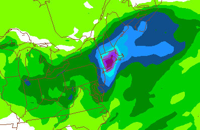
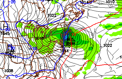
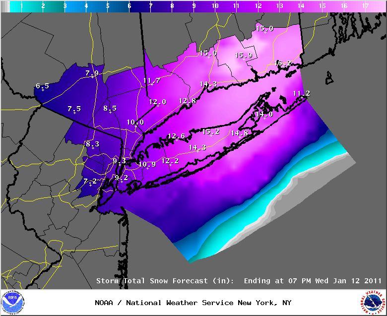
January 10th, 2011---: Early Evening Update | The 12z (7am) model runs, along with the 18z (1pm) runs are in and we're still on target for a major snow storm here in the NYC metro. This storm will also affect areas further up the coast near Boston so prepare up there as well! The National Weather Service in NYC has upgraded our Winter Storm Watch, to a Winter Storm Warning, and it seems that the snow fall totals have also been bumped up a bit for our area from what they were a little earlier. The current forecast is calling for anywhere between 7 and 12 inches of snow for the NYC Metro, with some higher amounts on central Long Island, and southern Connecticut. Right now the timing of the first flakes here in the NYC area is between 5pm and 7pm tomorrow evening. The latest 12z/18z runs of the NAM are still on the western edge of the guidance and if that model verifies, we could see some mixing with sleet and rain for the eastern LI area and SE Connecticut. After looking at all the latest guidance, this coastal storm looks to track very near, if not directly over the benchmark so bottom line, prepare for a good dumping of snow in the NY/NJ Metro. There is still some uncertainty on how much wind will be associated with this storm, but with all model guidance showing this storm rapidly deepening as it tracks off shore, we could at times see blizzard conditions overnight on Tuesday and into Wednesday morning. It's also not exactly clear where any heavier bands of snow will set up, but where they do, higher snow fall totals than what is shown below can be expected. Below is the latest snow fall totals forecast issued by the NWS at 4pm. And, if you would like to read the official watches and warnings issued by the NWS, click here. I'll have another update tomorrow morning.
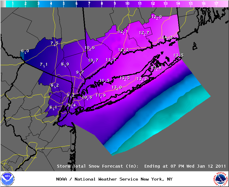
January 10th, 2011---: Morning Update | Ok, just finishing up with taking a gander at the 0z and 06z model runs and everything still looks on target for another major snow storm here in the NYC Metro area beginning tomorrow, and peaking during the overnight hours and into Wednesday morning. If you have travel plans during that time frame, please keep on top of the latest forecasts and consider changing those plans, or at least have alternate plans in place in the event things get really bad out there. On to the models, the latest runs of the NAM have the track of the storm almost directly over the crucial 70/40 benchmark which would bring the axis of heaviest snows into and over the NYC Metro. The latest GFS runs have the track a little bit east of the NAM with the axis of heaviest snows over Long Island. The latest 0z ECMWF run splits the difference for the most part. All in all the models do agree on a track close, if not over the benchmark so we can expect a major snow fall here in the Metro. Now, as far as winds are concerned, the models seem to be honing in on this storm rapidly deepening (strengthening) once it's off the Carolina coast and begins tracking towards the northeast. So blizzard conditions with blowing and drifting of snow are possible in the NYC/NJ Metro area late Tuesday evening and into Wednesday morning. Needless to say, this would make travel very difficult if not impossible. One thing I do expect this time around however is for about a hundred sanitation snow plows to be going up and down my block every hour, as opposed to last time when we didn't see a single plow for like 3 days, lol. I'm sure they will over kill it this time around. Still, if you don't have to go out, don't. Another thing of note is the possibility of some sleet and rain mixing in with the snow over eastern Long Island and coastal Connecticut. This will all depend on how far west the storm ends up tracking. Right now at least, it's looking like anyone from Suffolk County, LI and west will remain all snow. I plan to live stream throughout the entire event from my static web cam here in Queens, NY so be sure to check back for info on that! I'll have an evening update by 6pm tonight and will post updated snow fall totals, and will also sum up the latest model runs at that time as well. Below are the latest snow fall totals forecast issued by the National Weather Service at 5:45 this morning. These totals are of course subject to change.
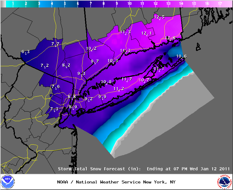
January 9th, 2011---: Evening Update | Things still are looking on target for what could be a major snow storm this coming Tuesday and into Wednesday here in the NYC/NJ Metro area. Points to our north and east (Cape Cod/Boston) are under the gun as well. The 12z suite of models, like previous model runs are for the most part in agreement on a track very near the 70/40 benchmark which if verifies will bring significant snows to the metro area. It's still however a bit too early to talk snow fall totals but there is a relatively high likely hood that the NYC metro and surrounding areas could see in excess of 8 inches of snow. Some mixing of sleet and rain is also possible out east over Long Island and coastal Connecticut, but this will depend on the exact track of the low. We'll leave it at that for tonight but I will have another blog update tomorrow morning. By that time I'm expecting a much clearer picture of the impacts of this storm since by then, we'll be within the 36 hour time frame.
January 9th, 2011---: The latest model runs are now honing in on what could be yet another significant winter storm affecting much of the northeast during the late Tuesday/Wednesday time frame. I am feeling more confident now in saying "here we go again!". There is still uncertainty in regards to the exact track (as is always the case), and also in the strength of the low as it tracks close to our area, but it is becoming more and more likely that we'll see another significant snow fall here in the NYC Metro area. If you're reading this and can do without all the weather geek mumbo jumbo, lol...no worries, just jump on down to the bottom for the summary. On to the models. The latest 12z (7am) ETA/NAM has just come out and is showing a track very near the 70/40 benchmark. This model is also showing a rather strong storm as it passes off shore with a central pressure forecast to be around 987mb. Next up, the 0z (7pm) ECMWF which is also showing a strong coastal storm tracking near if not over the benchmark. Both the ETA/NAM and the ECMWF are strengthening this low pretty considerably, which if verifies would bring strong winds to the tri-state area, along with heavy snows. Sound familiar?. Next up is the 09z SREF short range model which is also showing a track very near the 70/40 benchmark, but this model is not forecasting the storm to be as intense as it passes off shore as what the ECMWF and ETA/NAM are showing. Then we have the 0z (7pm) and 06z (1am) GFS runs which are both showing, like the other models, a track very near the all important benchmark. But, like the SREF the GFS is also showing a less intense storm as it tracks off the coast of NJ and Long Island late Tuesday night. So we have two models showing a more intense storm, and two models showing a less intense storm as it makes it's closest approach. So yeah, still uncertainty there.
Either way you cut it, we're still looking at a potentially significant snow fall here in the metro area, just might not have as much blowing and drifting of snow if the GFS and SREF verify. However, points further up the coast near the Cape and Boston would still be looking at potentially strong winds from this storm as all the models do forecast this system to strengthen as it tracks off to the northeast. The question will be, at least for our area of NYC/NJ, how rapidly the storm strengthens. If this storm rapidly strengthens (deepens) then we would see the strong winds here, if it does not deepen as rapidly, then our winds here would be less. So, to sum all this up. Right now plan for a significant winter storm affecting the area late Tuesday, Tuesday night and into Wednesday. If you have travel plans, definitely keep on top of the forecast as things can and will change as the forecast becomes more fine tuned. Also, it should be noted that depending on how close this storm tracks to the coast, there could be some mixing of sleet and rain in with the snow, especially over eastern Long Island. Treacherous driving conditions can be expected so beware. I plan to be live streaming as always from my static web cam here in Queens, NY so be sure to check back for more info as we get closer to this time frame! Below are some of the various forecast models, and what they are forecasting. Top Left: The 12z ETA/NAM 24hr precip model forecast for the time frame 1pm Monday-1pm Tuesday showing over an inch of liquid precip for the NYC metro and surrounding. This would equate to a good dumping of snow. Top Right: the 12z ETA/NAM forecast showing a rather strong storm off shore come 7am Tuesday morning. Bottom Left: the 0z GFS showing this coastal storm off shore at 7am Tuesday morning. Bottom Right: The 09z SREF showing a similar track for this coastal storm. As I always like to mention, I use these models are tools and they should never be taken literally. It's the weather, so nothing is written in stone. More updates later this evening.
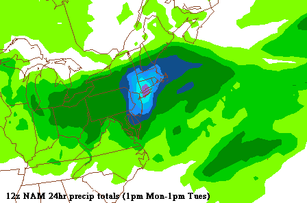
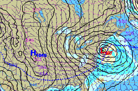
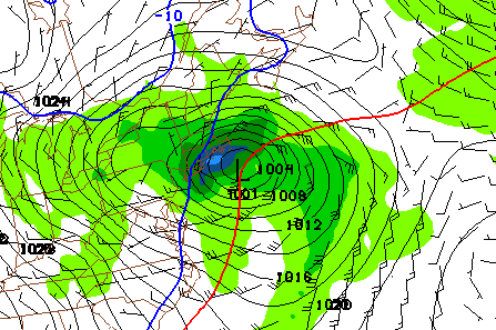
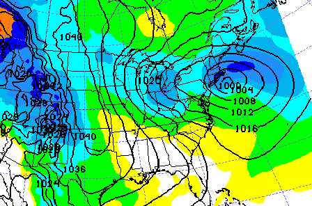
January 8th, 2011---: It's still a little bit too early to say "here we go again", but the various forecast models are in very good agreement of the development of yet another coastal low for the late Tuesday and early Wednesday time frame. We're still 72 hours out so there is still some uncertainty regarding the exact track of the coastal low, and more importantly how much snow will fall, but the ECMWF and SREF are both forecasting a track very near the 70/40 benchmark. The latest 12z GFS is an eastern outlier for the time being, but it's ensemble mean is for the most part in line with the ECMWF. Bottom line, it's too early to talk specifics, but if you have travel plans for later Tuesday afternoon and into Wednesday, definitely keep on top of the forecast! More updates tomorrow once things are a little clearer. Bottom left: the 12z ECMWF showing the forecast coastal low tracking very near the benchmark bringing heavy snows and strong winds to the area. Bottom right: the GEFS ensemble mean showing a similar track.
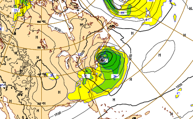
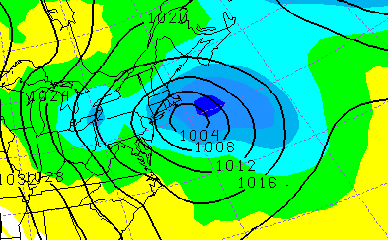
January 7th, 2011---: Live streaming from my static web cam here in Queens, NY will begin later this morning as the snow becomes heavier! Be sure to check my "Live Streaming" page for details!
January 6th, 2011---: Quick evening update here. Ok, so it is beginning to look more likely that the highest snow totals will stay out of the NYC area, this is not written in stone of course, but the latest model trends are pointing in that direction. Latest model runs are showing the axis of heaviest snows over parts of central/eastern Long Island, Connecticut and into the lower Hudson Valley and upstate NY. Thus, a Winter Weather Advisory is now in effect for the NYC Metro with 2 to 5 inches of snow expected. Areas to the east over central Long Island could see more, and points to the north of NYC could see 6+ inches but again, this will all depend on where the heavy snow bands set up, and persist. For NYC, the moderate to at times heavy snow should move in around 10am and last through the late afternoon/early evening. So to sum it up, this doesn't look like a major snow fall at this time. And, one big difference between this storm, and the Christmas weekend blizzard will be the lack of wind. The pressure gradient will be weak with this storm so that translates to very little wind. My live streaming plans are still in place so check back tomorrow for more information on that! If you'd like more information regarding the Winter Weather Advisory in effect for the NYC area, as well as the other watches and warnings in effect for the area click here. Just scroll on down until you see your location. Below is the latest snow fall totals graphic issued by the National Weather Service at 4:30 this afternoon.
January 6th, 2011---: Here we go again! A Winter Storm Watch has been issued for the NYC metro area for tomorrow, and right now the official forecast is calling for anywhere from 3 to 7 inches of snow. However, as is almost always the case, this is a very challenging forecast due to many of the models agreeing on a Norlun Instability Trough setting up shop very close to the NY/NJ Metro area. If the trough axis sets up right on top or near the city, it will greatly change the snow fall totals for this area. This trough axis will create areas of enhanced lift over a relatively localized area. This is commonly referred to as snow squalls. An area that happens to find itself under a snow squall band could see snow fall rates as much as 3 to 4 inches an hour! There is also a very sharp gradient to the heavy snow fall. These squalls are usually only a few miles wide, but can be very long in length. To give you an idea of how sharp this gradient can be, one of the forecast models is forecasting 18 inches of snow for Bronx, NY...and only 3 inches for Staten Island, NY. Only a few miles difference between those two locations. Basically plan for up to 7 or 8 inches of snow in and around the NYC Metro area, and Long Island. But, please keep in mind that these rates could go up, or down for that matter depending on your exact location. The definition of a Winter Storm Watch is that 6 or more inches of snow could fall within the watch area, and that consitutes a major snow fall no matter which way you cut it, so plan for that.
Another potential problem is all the garbage that is still littering the city streets from the Christmas weekend blizzard. Sanitation better get moving today! If I was the Mayor, I'd be sweating this BIG TIME! Hey, speak of the devil! I hear the garbage trucks outside my window and low and behold, my garbage has finally been picked up! Something tells me they may even overkill the situation, and instead of no plows for three days after the storm, we'll have 20 plows go down my block in one hour during the storm, lol. Getting back to the forecast, best bet is to stay tuned to this storm and check the latest forecasts a few times a day to see if things have changed for your area. Don't go on a forecast that's 12 hours old as things could have easily have changed in that time frame. I'll have another update here on my blog later this evening once the evening model runs are out. And once the snow begins tomorrow I'll be out and about documenting the storm as always! I'm also planning once again to live stream this storm from my static web cam here in Queens NY, so be sure to check back for that! Below are a few snap shots of various models I use showing where the heavier bands of snow *may* set up tomorrow afternoon and evening. On the left is the 0z run of the ETA/NAM showing the axis of heaviest snow setting up over Long Island, through NYC and into the Hudson Valley including parts of Connecticut. On the right, the 0z run of the GFS showing the axis of heaviest snow further to the northeast over parts of CT/MA and upstate NY. Again, it's very tough to determine exactly where the worst will be so stay tuned, and hopefully things will be a bit more in focus this evening. One more thing of note...we're going to have to keep an eye on the next Tuesday time frame, another potential coastal storm may take shape. We won't worry about that right now though, let's deal with this storm first, lol.
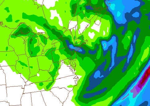
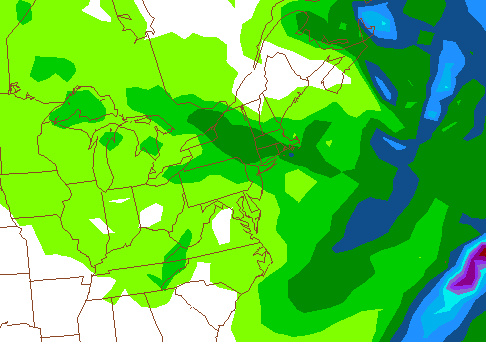
January 5th, 2011---: Ok, here's a potential set up you don't see very often around the NYC area. The various forecast models are forecasting an inverted trough, or a Norlun Instability Trough to set up somewhere around the NYC/NJ Metro area this Friday. To simplify, a Norlun Trough creates areas of enhanced instability over a very narrow, but very long area. Basically we're talking about possible snow squalls setting up shop near, or over the metro area this Friday and Friday night. Not something you see very often around here but it has happened in the past. One event near Cape Cod in February 1993, and another in March 1992 in Maine. To read up on those events, Click here. In the case of the Cape Cod event, only a few inches of snow was forecast for that area, but almost 20 inches ended up falling where the squalls set up. And most of that fell within just a few short hours! Now that's not to say this is what is going to happen here in the NYC area on Friday, but I can tell you this...if I was head of sanitation here in the city, I'd be sweating bullets right about now, LOL. After the botched clean up efforts in the wake of the Christmas weekend blizzard, the last thing they need right now is another major snow fall. My garbage STILL has not been picked up. Another big event on Friday would really wreak havoc here in the city. Needless to say it will be interesting to see how this all pans out. So getting back to the forecast, right now both the GFS and ETA/NAM are showing areas of enhanced snowfall for the NYC area Friday evening. Will this come to fruition? Still too early to tell exactly where any enhanced areas of snow fall will set up. The NWS does seem rather confident however that some areas will see enhanced snow fall, but we're still 48 hours out, and as with all winter weather events, things won't become clear for another 24 hours or so. Right now the official forecast for the NYC metro is for 3-6 inches, so plan for that. But, I'll be updating more as we get closer to the event so stay tuned! This is a very complicated forecast so I expect more changes to come. Below left: Today's 12z (7am) ETA/NAM 24 hour precipitation forecast for the time frame 7am Friday morning through 7am Saturday morning showing enhanced areas of precipitation over and near the NYC/NJ Metro. Below right: the latest 12z run of the GFS showing a similar enhanced area of precipitation setting up shop Friday evening over and near the NYC/NJ Metro.
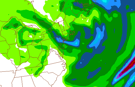
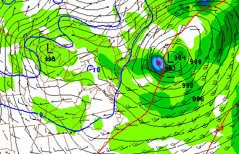
January 4th, 2011---: The first week of the new year so far has been rather quiet, both here in NYC, and throughout the northeast as a whole. Low temperatures have been a bit on the cold side, but nothing too extreme for this time of year. That will all be changing late this week as a series of shortwaves will be traversing the northeast, bringing with them the possibility of some light snow on Friday. The forecast models are also trying to get a handle on an off shore storm that is forecast to take shape late on Friday and Friday night, and move up the coast this Saturday. Right now at least, both the latest runs of the GFS and the ECMWF (Euro) are showing this off shore storm staying far enough from us to bring any significant snows to the area, but as we saw recently, things can change. However, model agreement right now looks pretty good on a track to the south and east of the 40/70 benchmark. It's this off shore storm that is the wild card right now. If this storm stays far enough away from the coast, I'm anticipating just light snows on Friday/Friday night in our area. Parts of eastern New England however could see more significant snows from this system, so be on your guard up there. More updates to come as we get new model data in. Below left is the latest 0z run of the ECWMF (Euro) showing this off shore storm and where this model is forecasting it to be located come 7pm Saturday night. Below right, the GFS forecast for this storm for the same time frame.

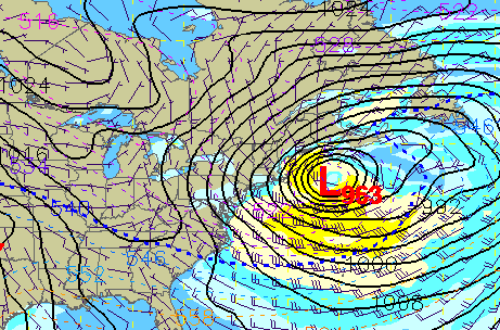
January 2nd, 2011---: We're still in the process of cleaning up here from the last big snow event in NYC and already, some of the models are beginning to hint at what could be another snow event late this week, and into the weekend. A strong clipper system is forecast to track from the Great Lakes, into the northeast late this week and could bring with it several inches of snow to the area. Many questions still remain however. The models are also forecasting a southern stream shortwave to be moving off the coast, will this clipper system interact with the shortwave? Or, will the shortwave be too progressive. That's just one of the questions facing forecasters right now. Even if there is no interaction with the southern stream, this clipper system still has the potential to bomb off the NE coastline so things could get interesting regardless. Still too early to tell exactly what's going to happen as is always the case this far out. But, I'll be keeping an eye on things over the coming days. In the meantime, enjoy the relatively warm temperatures today..they're not going to last long, lol.
January 1st, 2011---: Happy New Year everyone! Another year is upon us and hopefully 2011 will be a happy, healthy and prosperous one for us all! Looking forward to another year of witnessing, and documenting natures wonders.