
Share this page!

Custom Search
|
Click here to select another year
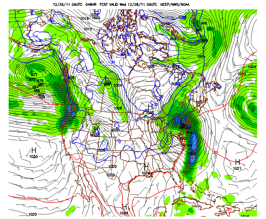
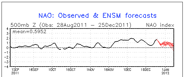
December 26th, 2011---: It was one year ago today that we experienced a major winter storm here in the northeast. The Christmas Weekend Blizzard as it has been named snarled holiday travel for millions of folks throughout the country. I was out in the thick of it and this video can be viewed on my "latest storm videos" page. What a difference a year makes! Today we're not looking at any winter storms here but instead will experience tranquil conditions under mostly sunny skies and temperatures in the mid 40s. This will not last long however, a powerful storm will track into our area from the southwest tomorrow and by tomorrow evening the rain will begin to fall here in the NYC area. This low pressure system is currently forecast to track right over, or just west of the NYC area thus putting us on the warm side of the storm. All rain is expected here at the coast, and any snow accumulations are expected well to the north and west of us near the Finger Lakes region, and into Upstate NY. For us here in the NYC area we can expect a brief period of heavy rains and possible strong winds during the overnight hours tomorrow night (Tues) into Wednesday morning. Winter has only just begun however so there is still plenty of time for the major cities in the northeast to see significant snows, we have to remember, the past few years featured some early season events, but our snow season doesn't typically begin until January. With that said, I just took a look at the current NAO (North Atlantic Oscillation) and we're still observing reading in the +1 to +2 range. When experiencing a positive NAO like we have been seeing for about two months now it is quite difficult to get significant winter storms to ride up the east coast due to the fact that above normal heights (high pressure) are being seen in the western/north Atlantic. This is just one of the factors however, but I have noticed that some of our big winter weather events have been in negative NAO patterns. You'll notice however on the chart below that the forecast (red lines) calls for a trend more towards neutral as we get into the new year. We will see if this verifies. Stay tuned!
Top Image: The 06z GFS model forecast for 1am Tues night/Wed morning showing a powerful low pressure system tracking just west of the NYC metro bringing with it a brief period of heavy rains and strong winds. Bottom Image: The observed NAO readings (black line) and the ensemble forecast (red lines) showing a possible trend more towards neutral over the coming week or two.
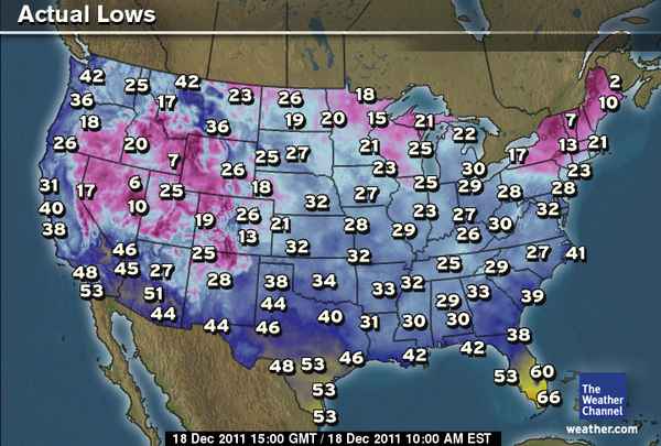
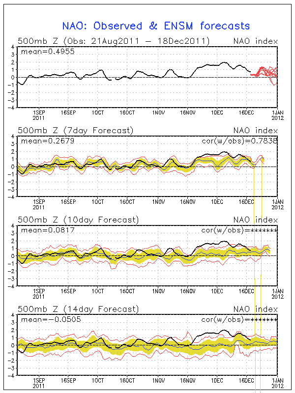
December 18th, 2011---: The first real cold surge of air moved into the northeast this morning as I awoke to temperatures in the low 20s here in NYC! Now THIS feels like winter! But, as has been the case this Fall, the shots of cold air have been very short lived. And this one will be no different. By early week temperatures will once again surge into the 40s to near 50 with some unsettled weather moving back in by Tuesday night, and lasting through late week. Overall the pattern we've been in since our big late October snow storm has been a tranquil one. No big storms and no really big shots of cold air have over taken the northeast. I have a feeling this will change over the coming weeks so enjoy it now while it lasts! The current phase of the NAO (North Atlantic Oscillation) remains on the positive side and this usually translates to above normal heights (high pressure) in the western and north central Atlantic. Because of this, storms have a tendency to take a track south of our area and right out to sea, they also have a tendency to be fast movers. Very difficult to get a strong storm tracking right up the coast in a pattern like this. The current NAO forecast however is showing a trend back towards neutral as we get towards the beginning of the new year. The actual observed NAO seems to be falling more in line with the ensembles forecast, unlike the past few weeks when the observed readings were running way above forecast. Because of this, I am putting a little more stock into the forecast. What does this all mean? Well, the NAO phase is just one of the factors we look at when it comes to pattern changes, but if we do in fact trend towards neutral and even negative, then it's a good bet that we will begin to see a shift towards more typical winter time weather here in the northeast. Stay tuned!
Top Image: Actual low temperatures here in the US this morning. Now this looks more like typical winter. Bottom Image: The current NAO chart showing the observed readings, and the forecast for a trend (red lines) more towards neutral over the coming weeks.
December 12th, 2011---: Just got word that some of my footage will be airing on the program "2011: The Year the Earth Went Wild" this coming Thursday, December 15th at 9pm ET immediately following "Storm Chasers" on the Discovery Channel! This show will cover everything from the Japan earthquake in March, to the devastating tornado outbreaks on the plains during the spring, Hurricane Irene, and the numerous record breaking snow storms that hit the US this year. Some of my footage will be featured in this program so be sure to check it out!
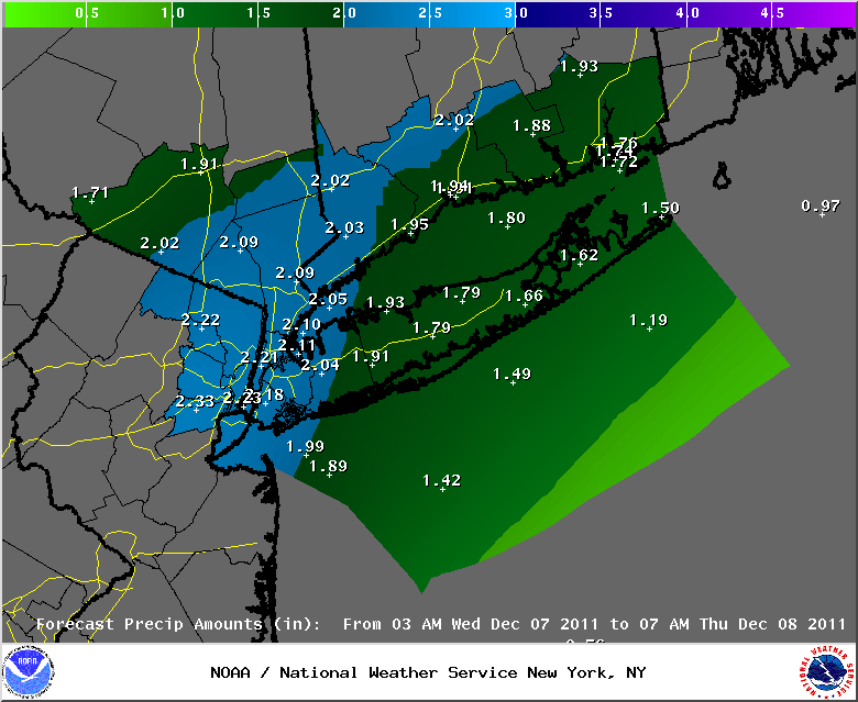
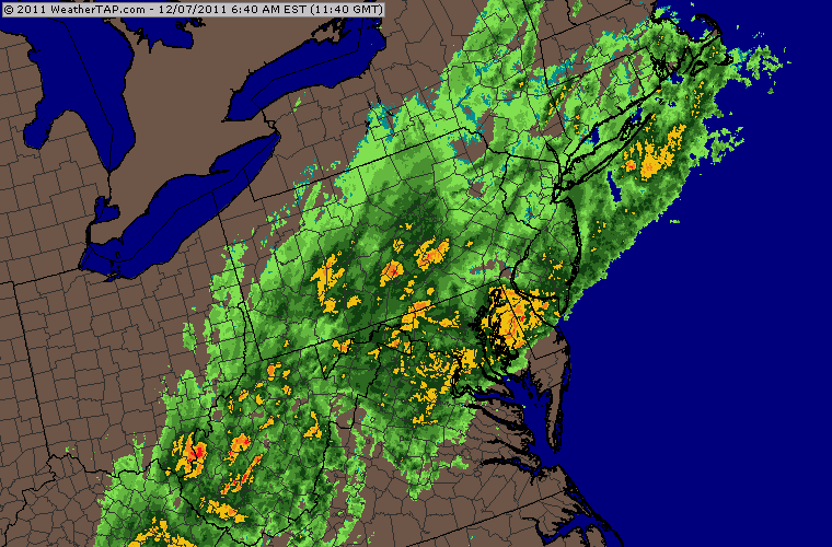
December 7th, 2011---: Our first nor'easter of meteorological winter is currently affecting the entire I-95 corridor, and here in NYC the rain has begun! This time around however, we will be seeing an all rain event here at the coast, but areas north of us, into parts of Massachuttes and Vermont could see upwards of 6 to 8 inches of snow. Parts of upstate NY could also see a slushy few inches of accumulations. Overall though the main story for this storm will be the rain, and speaking of rain, there will be lots of it! Areas in and around the NYC metro can expect 2 to 3 inches total by the time things begin winding down tomorrow. Top Image: latest rain fall totals forecast for NYC/NJ/LI and CT Bottom Image: Regional radar image from 8am this morning showing the moderate rains moving along and up the I-95 corridor
November 27th, 2011---: Another day of above average temperatures is on tap for today here in NYC! Islip, NY broke a record high yesterday with 66 degrees, and JFK Airport tied a record high set back in 2001 of 64 degrees! We should see temperatures in the mid 60s once again today, and tomorrow. After that, the weather will begin to go down hill as a storm system takes shape and tracks to the west of the tri-state area. Rain should begin moving into the area Monday night, with Tuesday and Wednesday being the wettest days of the week. After that the sun is forecast to return with near normal temperatures later in the week and next weekend. We're in a positive phase of the NAO North Atlantic Oscillation, and a very strong positive phase at that (approaching +2). What this means is that we can expect to see above average heights (high pressure) in the central North Atlantic for the time being. This usually translates to high pressure and above average temperatures in the east, and no big storms/nor'easters tracking up the coast. We'll see if this actually ends up being the case. This pattern will not last forever however so enjoy the near to above normal temperatures while they last!
In other news, I was featured in an NBC NY special titled "Severe Weather In The Tri-State" that aired on NBC NY NonStop yesterday. We discussed severe weather safety, my storm chase adventures, and the tornadic storm that slammed my neighborhood back in September 2010. The video below shows NBC NY Chief Meteorologist Janice Huff and I taking a walk through my neighborhood of Rego Park, Queens and discussing the events of that day!
View more videos at: http://nbcnewyork.com.
November 24th, 2011---: I will be featured in an upcoming severe weather preparedness special called "Severe Weather In The Tri-State" airing this Saturday, November 26th at 12:30pm/6pm, and again on Sunday, November 27th at 12:30pm on the NBC NY NonStop channel! We discuss my storm chase adventures in tornado alley, severe weather safety, and the Queens, NY tornadic storm that heavily damaged parts of Brooklyn, as well as my neighborhood of Middle Village and Forest Hills back on September 16th, 2010! Below is the channel information for the various cable providers in the NYC/NJ area.

November 21st, 2011---: The leaves are almost gone from the trees in and around NYC, but for the most part we haven't seen any real cold shots of air so far this month, the key word is...so far. A low pressure system is forecast to take shape early/mid week and the timing will, at least as it stands right now, bring the worst of the weather in for the later part of Tuesday, and into the day on Wednesday. This will make things a bit difficult for folks traveling this Thanksgiving Eve, but thankfully this is looking to be a mainly, if not all rain event for the northeast. The low pressure system is forecast to pass to the west and north of the NYC metro, so we'll be on the warm side of things here at the coast. Even areas inland will see mostly rain. However, some of the usual higher elevations could see some snow out of this, as well as areas well to the north of us. Another factor will be gusty winds as the low pressure strengthens and tracks through the area. All in all, expect a wet go of it from Tuesday afternoon, straight through the day on Wednesday. As it stands right now, Thanksgiving day is looking mostly sunny with highs in the low to mid 50s. Hopefully the timing will hold and we'll be able to salvage the day!
In other news, I set aside a few hours and put together a 17 minute highlights video showcasing all my tornado highlights spanning the years 1999-2011! 12 years/13 seasons total. The video is essentially wall to wall tornadoes. If you're interested in checking it out, navigate to my "Latest Storm Videos" page!
November 13th, 2011---: We have now past the peak of the fall foliage season here in NYC, and once that happens, it surely means that cold wintry days are on the way. All though I have to say, the past few days have been pretty great for this time of year! Actually most of November so far has been really nice. November is notorious for cloudy, chilly and blustery days, but this year we've been lucky so far. It's been for the most part consistently nice since the record breaking early season snow storm back on October 29th! So no complaints, the cold raw days will be here soon enough. Getting back to the fall foliage, we just had what in my opinion was the best foliage season of the past few years here in NYC. I spent a day last week in Central Park and the colors were spectacular! I have posted a 2 minute highlights video on my YouTube channel, as well as here on my "latest storm videos" page. Check it out!
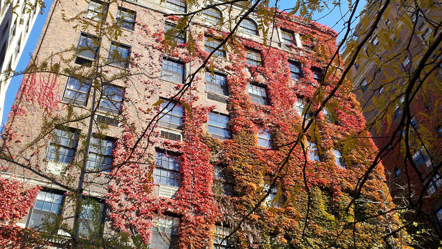
November 6th, 2011---: The fall colors are at their peak here in NYC and while walking down 68th Street on the east side of Manhattan today, I stumbled upon this building that had ivy, at it's peak fall colors crawling up the side!! A trip to Central Park is planned for this Tuesday to document the fall colors in the Park. Can't wait! Daylight Savings Time has also come to an end as of last night, so it's official....winter is on the way! Actually, we've already gotten a good taste of it with our early season snow storm last week.
October 30th, 2011---: Well we're off to a heck of a start here in NYC! Only one month removed from summer, and we've already had our first snow storm. And this wasn't your normal snow storm, this was historic! NYC's Central Park has never received more than .8 inches of snow in October, well we smoked that record yesterday. The official total at the Park was 3 inches, and it was about the same here at my place in Queens! I spent the majority of yesterday documenting this event and it was truly a miserable experience. One of my worst ever in fact. Here's why. I make one crucial error, and that was I did NOT wear my fully waterproof snow boots and instead opted for my Timberland boots. BIG mistake! Water got in them within a half hour of arriving in Manhattan and I literally had to spend the next four hours with soaking wet feet while out documenting the storm. Truly a miserable experience, worth it in the end, but I tell you this...I will never make that mistake again. I should have taken the time to fully prepare for this storm, I know better, but rushed out the door because I was caught off guard by the fact that the rain changed to snow about 6 hours earlier than forecast. In my mad dash to get out the door, I didn't take the time to dig in the closet for my snow boots and went for what was closer to me. Lesson learned! So anyways, I did manage some good video I think and even captured footage of large chunks of heavy wet snow falling from the skyscrapers in Manhattan, and impacting the streets and sidewalks below. One large chunk even struck me directly in the head, but thankfully it was just snow, and no ice so I was fine. If you are interested in checking out my 4 minute video of this historic storm, bounce on over to my "Latest Storm Videos" page and check it out! Below are the official snow fall totals for the area. Still many thousands without power, but thankfully we never lost it here...we did lose a ton of trees area wide however! The heavy snow and the fact that many of the trees here in the NYC Metro still have their leaves made for a bad combination. All in all, an intersting way to start things off and only time will tell what Winter 2011-2012 will have in store for us.
********************STORM TOTAL SNOWFALL********************
CONNECTICUT
...FAIRFIELD COUNTY...
DANBURY 17.2 800 AM 10/30 SKYWARN SPOTTER
RIDGEFIELD 15.5 1015 PM 10/29 PUBLIC
SHELTON 12.8 745 AM 10/30 PUBLIC - 480 FT
GREENWICH 12.0 1230 AM 10/30 PUBLIC
BETHEL 11.5 830 AM 10/30 SKYWARN SPOTTER
3 SSE BROOKFIELD 11.0 700 AM 10/30 COCORAHS
BROOKFIELD 11.0 700 AM 10/30 SKYWARN SPOTTER
WILTON 10.8 840 AM 10/30 PUBLIC
MONROE 10.5 930 AM 10/30 SKYWARN SPOTTER
NEW CANAAN 6.0 400 AM 10/30 CT DOT
NORWALK 5.5 600 AM 10/30 PUBLIC
NEWTOWN 5.0 323 PM 10/29 SKYWARN SPOTTER
BRIDGEPORT 4.0 715 AM 10/30 NWS COOP
DARIEN 3.5 559 PM 10/29 SKYWARN SPOTTER
...MIDDLESEX COUNTY...
EAST HADDAM 8.1 830 AM 10/30 PUBLIC
OLD SAYBROOK 2.5 400 AM 10/30 CT DOT
HADDAM 2.0 400 AM 10/30 CT DOT
...NEW HAVEN COUNTY...
OXFORD 12.3 1230 AM 10/30 SKYWARN SPOTTER
SOUTHBURY 10.5 400 AM 10/30 CT DOT
BEACON FALLS 8.8 400 AM 10/30 CT DOT
WATERBURY 8.8 400 AM 10/30 CT DOT
NORTH HAVEN 7.7 705 AM 10/30 SKYWARN SPOTTER
SEYMOUR 7.0 457 PM 10/29 PUBLIC
HAMDEN 7.0 740 AM 10/30 PUBLIC
MERIDEN 7.0 400 AM 10/30 CT DOT
2 NW NEW HAVEN 2.8 800 AM 10/30 COCORAHS
3 ESE MILFORD 2.6 1010 AM 10/30 COCORAHS
...NEW LONDON COUNTY...
3 WNW OAKDALE 8.1 700 AM 10/30 COCORAHS
LISBON 5.9 440 AM 10/30 SKYWARN SPOTTER
COLCHESTER 3.5 400 AM 10/30 CT DOT
NORWICH 2.3 400 AM 10/30 CT DOT
GROTON 1.5 400 AM 10/30 CT DOT
STONINGTON 0.9 600 AM 10/30 SKYWARN SPOTTER
NEW JERSEY
...BERGEN COUNTY...
1 SSE OAKLAND 8.4 715 AM 10/30 COCORAHS
1 W TENAFLY 6.7 630 AM 10/30 COCORAHS
WNW OAKLAND 6.2 800 AM 10/30 COCORAHS
TENAFLY 5.8 1100 PM 10/29 PUBLIC
GARFIELD 5.3 959 AM 10/30 SKYWARN SPOTTER
SADDLE BROOK 4.8 800 PM 10/29 SKYWARN SPOTTER
RIDGEWOOD 4.7 800 PM 10/29 SKYWARN SPOTTER
1 SSE HAWTHORNE 4.5 700 AM 10/30 COCORAHS
RAMSEY 4.2 800 PM 10/29 SKYWARN SPOTTER
MIDLAND PARK 4.0 336 PM 10/29 PUBLIC
DUMONT 3.0 319 PM 10/29 NWS EMPLOYEE
WYCKOFF 1.9 532 PM 10/29 SKYWARN SPOTTER
...ESSEX COUNTY...
NORTH CALDWELL 12.0 1000 PM 10/29 SKYWARN SPOTTER
WEST ORANGE 8.0 945 PM 10/29 SKYWARN SPOTTER
VERONA 7.5 830 PM 10/29 OBSERVER
BLOOMFIELD 6.3 815 PM 10/29 SKYWARN SPOTTER
MONTCLAIR 6.0 1000 PM 10/29 PUBLIC
CEDAR GROVE 5.3 452 PM 10/29 PUBLIC
NEWARK AIRPORT 5.2 200 AM 10/30 FAA CONTRACT OBSERVER
BELLEVILLE 4.9 516 PM 10/29 SKYWARN SPOTTER
...HUDSON COUNTY...
N HARRISON 4.3 700 AM 10/30 COCORAHS
HARRISON 4.3 500 AM 10/30 SKYWARN SPOTTER
KEARNY 4.0 1200 AM 10/30 PUBLIC
HOBOKEN 2.0 743 AM 10/30 SKYWARN SPOTTER
...PASSAIC COUNTY...
WEST MILFORD 19.0 1020 PM 10/29 SPOTTER-1100FT ELEV
RINGWOOD 12.5 740 AM 10/30 SPOTTER-900FT ELEV
WAYNE 7.0 600 PM 10/29 SKYWARN SPOTTER
1 SSW WAYNE TWP 6.5 700 AM 10/30 COCORAHS
1 WNW LITTLE FALLS T 5.9 800 AM 10/30 COCORAHS
1 SSE HAWTHORNE 4.5 700 AM 10/30 COCORAHS
...UNION COUNTY...
ROSELLE PARK 4.8 532 PM 10/29 SKYWARN SPOTTER
ELIZABETH 3.8 1000 PM 10/29 SKYWARN SPOTTER
NEW YORK
...BRONX COUNTY...
FIELDSTON 6.0 1155 PM 10/29 PUBLIC
BRONX 2.2 421 PM 10/29 PUBLIC
...KINGS COUNTY...
MIDWOOD 2.2 234 PM 10/30 COOP OBSERVER
SHEEPSHEAD BAY 2.1 1045 PM 10/29 SKYWARN SPOTTER
MARINE PARK 1.5 600 PM 10/29 PUBLIC
...NASSAU COUNTY...
MINEOLA 4.0 503 PM 10/29 SKYWARN SPOTTER
WOODMERE 2.3 200 AM 10/30 PUBLIC
NORTH MASSAPEQUA 2.1 1230 AM 10/30 PUBLIC
...NEW YORK COUNTY...
CENTRAL PARK 2.9 200 AM 10/30 CENTRAL PARK ZOO
...ORANGE COUNTY...
HARRIMAN 16.0 1220 AM 10/30 SKYWARN SPOTTER
WARWICK 15.5 850 AM 10/30 SPOTTER-700FT ELEV
MONROE 12.0 915 PM 10/29 PUBLIC
HIGHLAND MILLS 12.0 1020 PM 10/29 PUBLIC
FLORIDA 12.0 900 AM 10/30 PUBLIC
MIDDLETOWN 12.0 1200 AM 10/30 PUBLIC
NEW WINDSOR 11.5 1215 AM 10/30 PUBLIC
CORNWALL LANDING 11.5 1126 PM 10/29 SKYWARN SPOTTER
CHESTER 10.7 555 PM 10/29 PUBLIC
TUXEDO PARK 10.3 944 PM 10/29 PUBLIC
NEWBURGH 8.7 1016 PM 10/29 SKYWARN SPOTTER
BLOOMING GROVE 8.3 556 PM 10/29 SKYWARN SPOTTER
GARDNERVILLE 7.5 930 PM 10/29 PUBLIC
...PUTNAM COUNTY...
KENT CLIFFS 12.0 1000 PM 10/29 PUBLIC - 650 FT
MAHOPAC 12.0 1040 AM 10/30 SKYWARN SPOTTER
CARMEL 11.0 630 AM 10/30 NWS COOP
BREWSTER 7.0 956 PM 10/29 SKYWARN SPOTTER
...QUEENS COUNTY...
ASTORIA 2.0 1100 PM 10/29 PUBLIC
NYC/LA GUARDIA 1.7 200 AM 10/30 FAA CONTRACT OBSERVER
NYC/JFK AIRPORT 1.5 200 AM 10/30 FAA CONTRACT OBSERVER
HOWARD BEACH 0.5 700 PM 10/29 SKYWARN SPOTTER
...RICHMOND COUNTY...
BAY TERRACE 3.5 1230 AM 10/30 SKYWARN SPOTTER
ANNADALE 2.4 945 PM 10/29 PUBLIC
1 SE STATEN ISLAND 2.0 800 AM 10/30 COCORAHS
...ROCKLAND COUNTY...
TALLMAN 5.5 435 PM 10/29 PUBLIC
NEW CITY 5.0 420 PM 10/29 PUBLIC
STONY POINT 4.0 1100 PM 10/29 SKYWARN SPOTTER
...SUFFOLK COUNTY...
HOLTSVILLE 2.5 700 AM 10/30 PUBLIC
ISLIP AIRPORT 0.3 200 AM 10/30 FAA CONTRACT OBSERVER
UPTON 0.2 200 AM 10/30 NWS OFFICE
...WESTCHESTER COUNTY...
ARMONK 12.5 1230 AM 10/30 PUBLIC
MILLWOOD 12.4 300 AM 10/30 PUBLIC
SOMERS 12.0 1100 PM 10/29 PUBLIC
SCARSDALE 10.0 1200 AM 10/30 SKYWARN SPOTTER
WHITE PLAINS 7.5 823 PM 10/29 PUBLIC
YONKERS 7.0 1220 AM 10/30 PUBLIC
MOUNT KISCO 7.0 905 PM 10/29 PUBLIC
MAMARONECK 7.0 800 PM 10/29 PUBLIC
HASTINGS-ON-HUDSON 6.5 1200 AM 10/30 PUBLIC
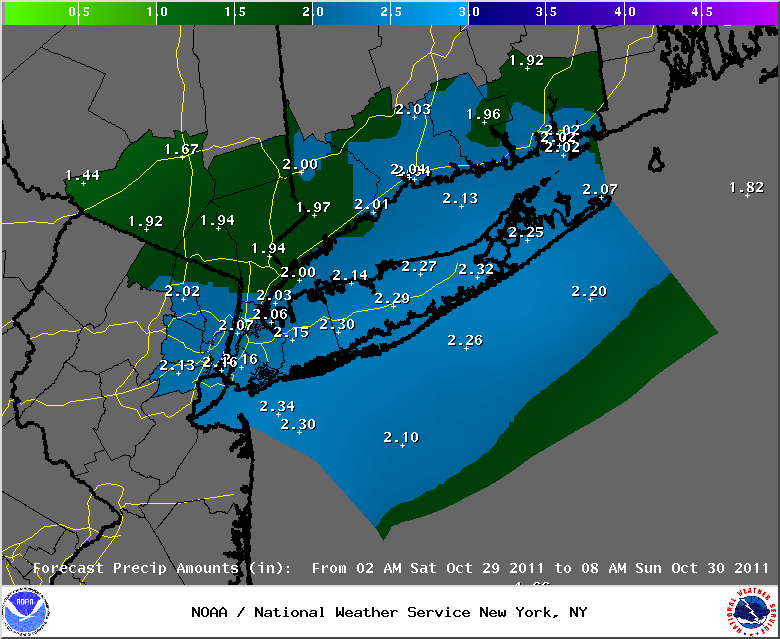
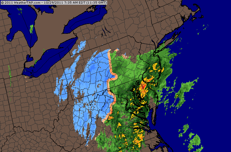
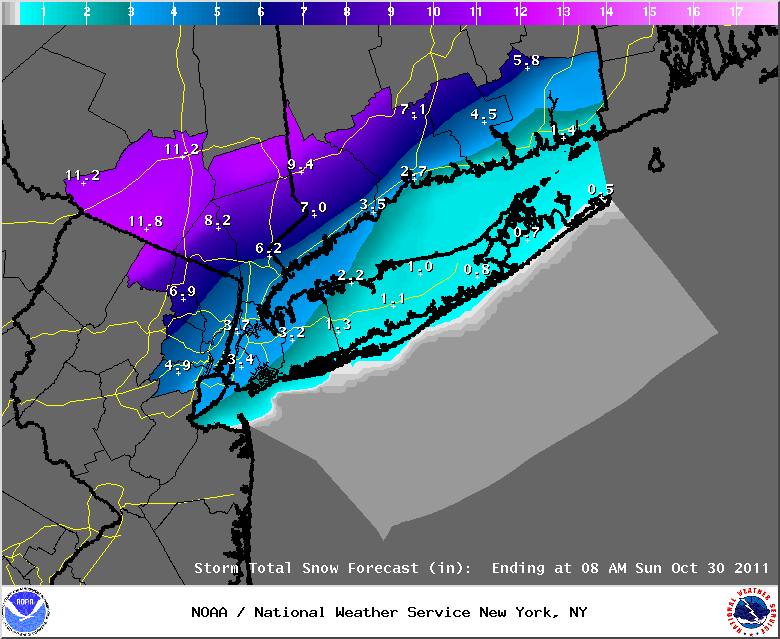
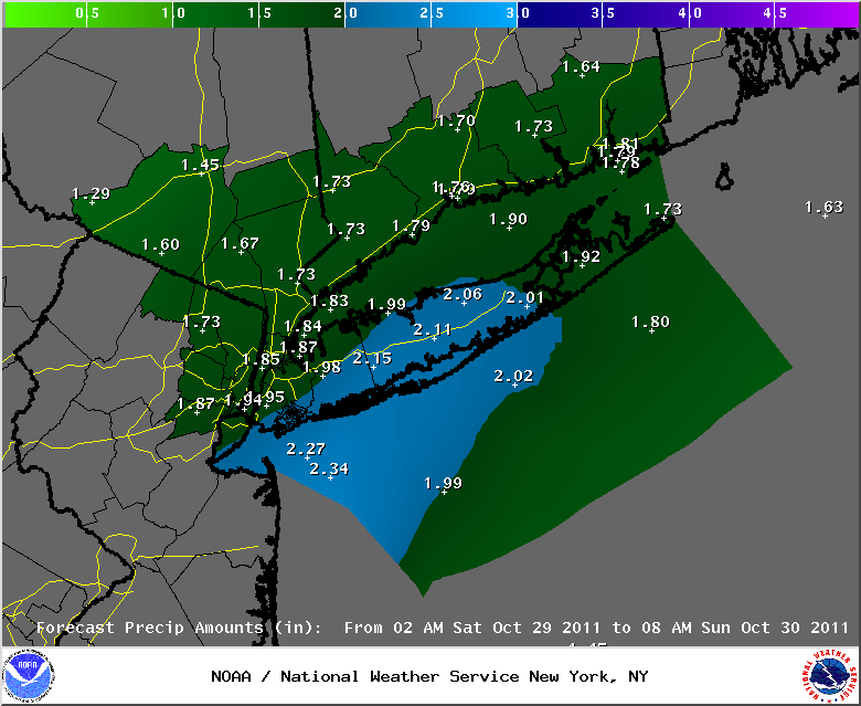
October 29th, 2011---: An historic storm is in the making right now for the northeast! A powerful nor'easter is moving up the coast and this storm will pass very close to the 70/40 benchmark later this evening. What makes this storm so incredible is that NYC's Central Park has never seen more than .8" of snow prior to Halloween! If the forecast verifies, this will be the first time since records have been kept that we get more than that. And records go all the way back to 1869! The official forecast for Central Park is 2-4" of heavy wet, slushy snow. With that said, areas along the coast where I am will see the least amount of the white stuff. And with the ground still being quite warm here in the city, don't expect the snow to stick around too long. If anything, I'm expecting most of the accumulations to be on the grassy areas and on cars. Still though, once the flakes begin to fly it will be a sight to see. And yes, there is the possibility that here in the city, the rain may never change over to snow, but for now at least, all signs are pointing towards flakes flying here in the city later this evening. Another issue with this system will be the very strong winds associated with it. By mid afternoon the winds will really be kicking up and because of this, the National Weather Service has issued a High Wind Warning for Long Island and a Wind Advisory for the NYC Metro. With most of the leaves still on many of the area trees, the snow fall, coupled with the strong winds could most definitely bring down some large branches and in turn, power outages are a real possibility. Either way, if you plan to be out and about later this afternoon and evening, take it slow and stay alert. Even if the snow does not stick to the streets around here, there will definitely be slick spots so take it slow! I plan to head out later this afternoon and document this storm, and I'm also planning on doing some live streaming, with audio from here at my homestead in Queens, NY. I'll be posting more details about all of this on my Twitter Feed. Top Image: The latest snow fall totals forecast issued by the National Weather Service this morning for the area. Middle Image: Latest rain fall totals forecast for the area. One thing of note, with over 2 inches of liquid precip forecast from this storm in and around the NYC Metro, if this was all snow, we would be looking at over 2 feet of snow area wide! Bottom Image: Radar animation of this storm wrapping up and moving up the eastern seaboard this morning. Radar courtesy of WeatherTap
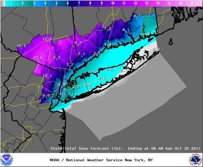
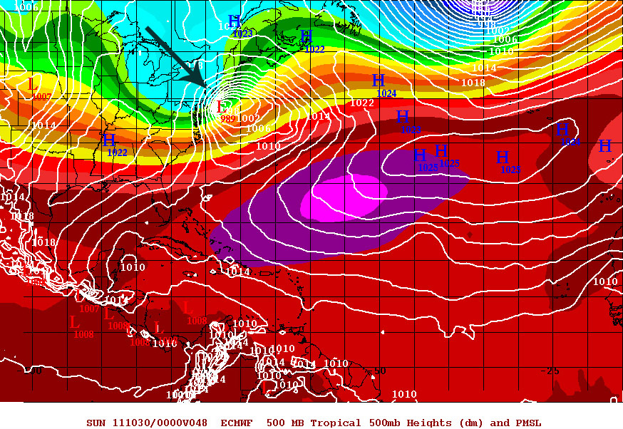
October 28th, 2011---: 6pm Quick update: This is getting interesting, lol. Updated snow fall totals below just issued by the National Weather Service here in NYC. 3-4" here in the city?? That would be a first, literally! Ever since records have been kept here in Central Park (1869) we've never received more than .8" of snow. Still a bit skeptical, but this is forecast to be a powerful nor'easter heading up the coast and if enough cold air gets dragged in as the low passes to our southeast, it can happen. Keep in mind though, the ground is still quite warm here so any snow that does fall will have a tendency to stick to the grassy areas, and cars first. For now, I'm expecting the streets to remain mostly wet. But, there will be slick spots for sure so watch out if you plan to be out and about tomorrow afternoon and evening. Also, with most of the leaves still on many of the trees in the area, power outages due to falling branches are a possibility. I'll have another update in the morning!Top Image: The latest 500mb forecast by the ECMWF showing a 989mb low passing over the 70/40 benchmark, just SE of the NYC Metro tomorrow evening. Middle Image: The latest snow fall totals forecast for the NY/NJ/LI and CT. Note how close the forecast bigger snow fall totals are to the NYC area. Bottom Image: Latest rain fall totals forecast for NY/NJ/LI and CT. Some of this will fall in the form of sleet, ice and snow..especially north and west of the NYC Metro.
October 28th, 2011---: Talk about an early season snow storm, but that's exactly what folks living a little bit north and west of NYC are facing for tomorrow. A classic nor'easter is forecast to ride up the coast right over, or very near the 70/40 benchmark. If this were a few weeks from now, we would be looking at one ass kicker of a snow storm area wide, but we are still very early in the season, so for us here at the coast, expect a mostly rain event. Notice I said *mostly*. The rain/snow line will be very close to the NYC metro and when the winds shift around, and that cold air gets drawn in, even us here along the coast could see some flakes flying by tomorrow evening. Much will depend on just how strong this storm gets, and that in turn will determine how much cold air is drawn in so those questions still remain. But what's looking fairly certain right now is that a powerful, early season winter storm will take shape tomorrow and ride up the coast in classic nor'easter fashion! The ultimate path and strength will dictate exactly what we see here along the coast in terms of rain/snow, I'll have another update regarding that tomorrow morning. But to give you an idea on just how rare it would be for us here in NYC to receive up to an inch of snow this early in the season, it's only happened three times in Central Park, prior to Halloween since 1869! In 1876 when .5 inches of snow fell at Central Park, in 1925 when .8 inches fell, and the last time this occured was 1952 when .5 inches fell in the Park. If by some chance we receive an inch here in Central Park, that will be a first, as we have never received more than .8 inches this early in the season. To sum up, as it stands right now my friends here in NYC/Metro NJ and Long Island can expect a windy and rainy day tomorrow with over an inch of rain expected throughout the day. As we get later into the afternoon, the winds will shift around to a more northerly direction which will usher in colder air. That's when we stand our best chance of seeing some flakes flying here at the coast! Now with all that said, is there the possibility that all of this could just be hyped up by the forecast models and what actually materializes tomorrow is something totally different? Yep, that's nature for you lol. Stay tuned!
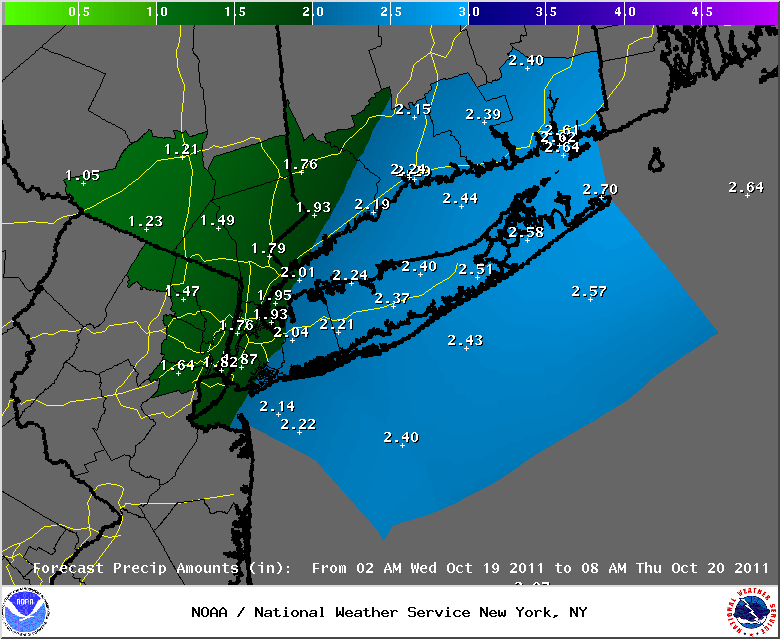
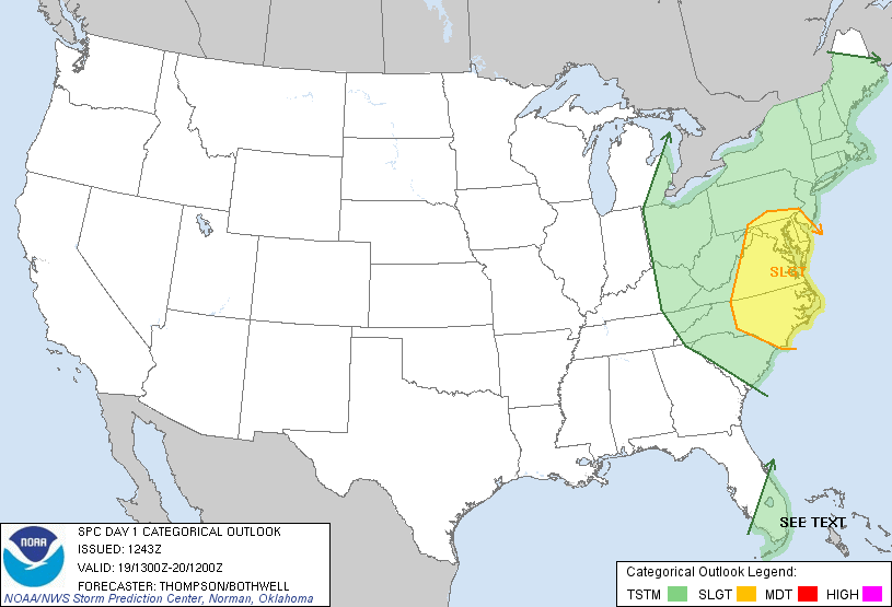
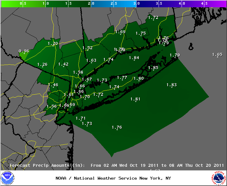
October 19th, 2011---: Our first significant Fall nor'easter has arrived! A strengthening low pressure system is riding up the eastern seaboard into the Ohio Valley today bringing with is moderate, to at times heavy rains to the entire area. The Storm Prediction Center also has areas south and southwest of the NYC Metro in a slight risk category for severe weather today. Big storms are not likely in and around the NYC area, but I'll be keeping an eye out regardless. However, I won't hold my breath. Overall the heaviest rains are expected to fall east of the NYC area, where up to 3 inches of rain could fall in spots. For the most part though expect between 1 and 3 inches of rain over central/eastern LI and into the New England states. For us here in the NYC area, I'm anticipating between 1 and 2 inches of rain, and we're already off to a good start with about one half inch of rain already falling at my place here in Queens. On top of the rains, expect the winds to increase this afternoon as well. By later today, we could be looking at wind gusts in the 30-40mph range. Hold on to your hats! Top Image: The current rain fall totals forecast issued by the National Weather Service this morning for the NY/NJ/CT and LI areas. Bottom Image: The latest convective forecast issued by the Storm Prediction Center at 8am showing areas south of NYC in a slight risk category for severe storms.
October 18th, 2011---: Get ready for a very wet and windy Wednesday here in the NYC area. A very deep trough is digging in along the east coast and this trough will aid in the formation of a coastal low that will move up the east coast, and pass southeast of NYC tomorrow afternoon and evening. This is actually a complex storm set up with one low pressure back to our west, and another one forming and moving up the coast. For those of us along the coast however, it's the coastal low that will bring us the majority of our rain and wind. Right now the forecast is calling for between 1 and 3 inches of rain between late tonight, and Thursday morning. If this were winter time, and cold air was in place, we would be looking at big snows for parts of the area. Maybe not here in the NYC Metro, as the coastal low is forecast to pass just to the southeast of us, but areas a bit north and west would have been looking at up to a foot of snow from this. But, we don't have to worry about that this time around. This will most definitely be an all rain event area wide. Image Below: The latest rain fall totals forecast issued by the National Weather Service here in NYC for the time frame early Wednesday morning through Thursday morning. And here are the latest Hazardous Weather Outlooks for the NYC Metro.
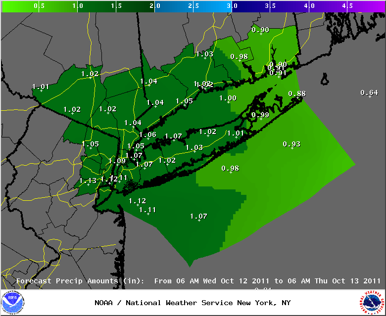
October 11th, 2011---: It couldn't last forever I guess. The incredible summer resurgence that we have all been experiencing in the NYC Metro will come to an end, and a return to more unsettled conditions, along with more fall like temperatures will return tomorrow. The storm system that has been affecting the south will be making it's way up the east coast tonight, and by tomorrow morning the rains should be knocking on our doorsteps. Right now the official forecast is calling for a little over an inch of rain area wide, some areas could see more however, and other areas could see less. But the time frame from tomorrow morning through Wednesday morning looks to be a wet one, with about one and a quarter inches of rain falling around the area. Thursday and Friday will remain somewhat unsettled as it stands right now, but the weekend is looking great, a classic fall weekend setting up in fact with sunny skies, breezy conditions, and temperatures in the middle/upper 60s. I'm very much looking forward to getting out there and shooting some fall foliage pics and video, but we are still a week or two away from the peak here in NYC, so I'll have to be patient. Image Below: The lastest rain fall totals forecast issued by the National Weather Service for the period Wednesday morning through Thursday morning.
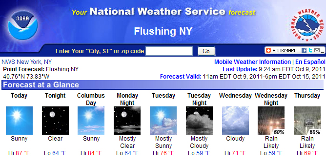
October 9th, 2011---: Is this Fall??! Well, it certainly doesn't feel like it that's for sure! As I type this I can hear birds chirping outside my window here in Queens, NY and the temperature is already in the low/mid 70s around the area! No complaints from me as the inevitable arrival of the cold weather will be here soon enough. So I'll be thoroughly enjoying this weather while it lasts. For today we're expecting highs in the upper 80s, more June and July like than October. Tomorrow will feature more of the same with sunny skies and temperatures in the low and mid 80s. Check out the forecast for the rest of the week below. We'll enjoy some incredible fall weather straight through Wednesday, but beginning on Thursday, we'll see a return to more unsettled weather. Get out and enjoy it while it lasts!
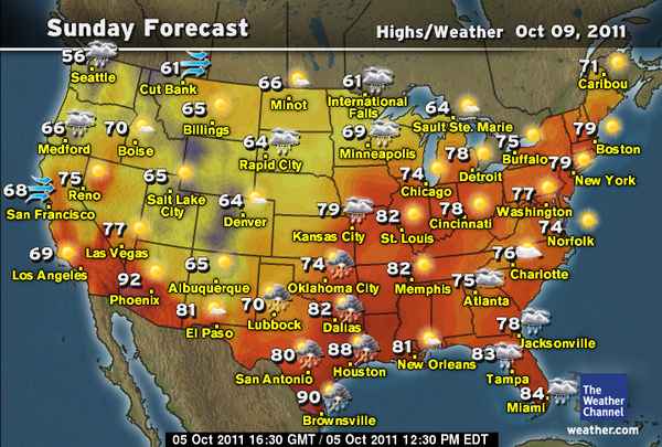
October 5th, 2011---: I thought the rains would never end! But they have, finally! That pesky cut-off low that just sat and spun over the Great Lakes and northeast literally took 2 weeks to clear the east coast. But as I type, the skies are clearing, and the sun is back out signaling an extended period of sunny and warm conditions. We will have a back door cold front move through this evening, which will briefly cool things down tomorrow (high temps only in the mid 60s), but from Friday on we'll be experiencing mostly sunny skies, with temperatures in the low to mid 70s straight through this upcoming weekend. Check out the forecast below for this coming Sunday!
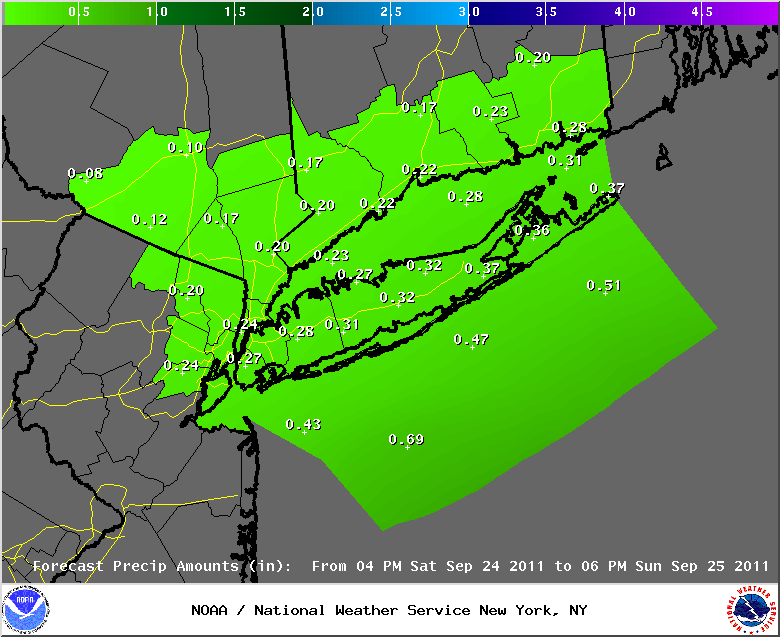
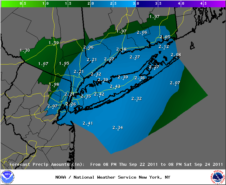
September 24th, 2011---: Today we experienced an extended lull in the rains, but it does appear that rain will make a return to the NYC area tomorrow afternoon. But, the current forecast has less rain than originally expected for my area. Over all about another 1/3" of rain is expected between now, and tomorrow evening. So far my rain gauge here in Queens, NY has measured 1.70 inches since yesterday morning. Numerous showers are forecast to be in the vicinity tomorrow afternoon, and any one of these could bring heavy rains with them. So some areas could end up receiving more than the expected 1/3". Anyone who has stepped outside these past few days knows that a deep tropical air mass has been in place over the area. This will continue for several more days. By Monday, it will feel more summer like than fall like here in NYC. Temperatures are forecast to top out in the low 80s with humid conditions. Tuesday will be a bit cooler, but still humid with temperatures in the upper 70s. And through all of this, rain will remain in the forecast. Right now, Monday could remain mostly dry. It appears that our rain chances will increase yet again on Tuesday, and thunder is in the forecast as well that day with some instability around. Either way, a wet and damp go of it for our area for at least a few more days. On another note, 2011 is the 9th wettest year on record for Central Park, NYC (so far that is). I think we will climb a bit higher on that list before 2011 is over and done with. Image Below: Rain fall totals forecast (4pm Saturday through 6pm Sunday) issued by the National Weather Service this afternoon.
September 23rd, 2011---: Quick afternoon update. Already received 1.25 inches of rain here at my place in Queens, NY. So it looks like we won't be on the lower end of the spectrum here in the NYC Metro. Look at all that heavy rain moving up from the south! Got a long way to go still.
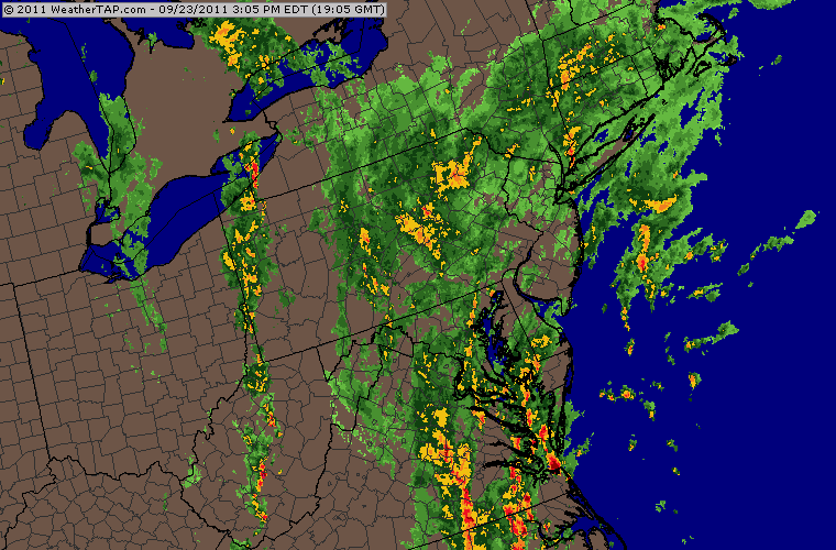
September 23rd, 2011---: The NYC/NJ Metro, along with all of Long Island, Connecticut and the Lower Hudson Valley are still in line to receive potentially flooding rains later today, straight through the day on Saturday. 1 to 4 inches is expected to fall in parts of the area, but like I stated in my update yesterday evening, it's still too early to tell exactly where those heavy bands of rain will set up. Some areas may only receive an inch of rain or so, while other areas a short distance away could get three to four times that amount. Stay tuned to your local forecasts for the latest on this rain event. Now as far as the set up goes, a warm front will approach the NYC metro this afternoon from the south, as it's associated cold front approaches the area from the west. Low pressure will form along this boundary bringing with it periods of moderate to at times, heavy rains to the area. The cold front is forecast to stall over, or close to the NYC metro tonight and rain will continue through tonight, and into the day on Saturday. The rains are expected to taper off a bit later tonight as the initial low pressure system moves away from our area, but another bout of moderate and heavy rains is expected tomorrow, as another wave of low pressure develops along the stalled front, and moves towards our area. Once again, it's tough to say where the heaviest rains will fall, but with a deep fetch of tropical moisture streaming up from the south (and you can feel that just by stepping outside), heavy rains are possible just about anywhere so stay tuned. Image Below: The lastest rain fall totals forecast issued by the National Weather Service at 8am this morning.
September 22nd, 2011---: Parts of the northeast are facing yet another potential flooding event beginning tomorrow (Friday) and continuing into Saturday evening. A plume of deep tropical moisture is streaming northward as a cold front approaches the northeast states from the west. This front is forecast to stall out over, or close to the NYC area tomorrow afternoon as waves of low pressure ride along this stalled front. The end result will be waves of heavy rains affecting the area beginning tomorrow afternoon, and continuing straight through the day on Saturday. Not good news at all for many of the flood ravaged areas of the northeast. It feels like we just dried out and now we're facing another flooding event. Some areas will get it worse than others, and there really isn't any way of telling what areas will get it the worst at this time. The forecast right now calls for between 1 and 4 inches of rain for parts of the area. If you happen to be in an area that only gets an inch, you should be all right. But 4 inches is another story. For the latest on the Flood Watch that is now in effect for the NYC/NJ/CT and the Lower Hudson Valley, visit the National Weather Service. I'll have more updates tomorrow as we get closer to this event. Image Below: The latest rain fall totals forecast issued by the NWS at 4pm this afternoon.
September 16th, 2011---: One year ago today my neighborhood here in Queens, NY was hit by a tornado and a macroburst! Extensive damage occurred throughout the city from these storms, most notably here in Middle Village, Queens and in parts of Brooklyn. Definitely a day I will never forget! Check out my video below from that day. In other news, we're getting a bit of a Fall preview here in NYC and the northeast as a whole today! A strong cold front swept off shore yesterday afternoon ushering in the coolest air mass since early May. I awoke this morning to temperatures hovering right around 50 degrees. High temperatures today and tomorrow will only top out in the 60s, but no worries...if you like the warm weather, it will make a return by late in the weekend. Temperatures are expected to rebound into the mid 70s for much of next week. The warm weather is not done with us yet!
September 14th, 2011---: Fall will be in the air late this week and into the weekend! A strong cold front will sweep off the east coast tomorrow evening and will usher in the coolest air we have seen here in the northeast since early Spring! After one more day today and tomorrow of summer like temperatures, the thermometer will drop significantly tomorrow night and by Friday morning we could be waking up to temperatures in the upper 40s here in the NYC Metro, with low 40s in the usually colder spots north and west of the city! High temperatures both on Friday and Saturday are only forecast to be in the mid and upper 60s in and around the NYC/NJ Metro. This is a good 7-10 degrees below normal for this time of year, but by no means will it be "cold". However, a light jacket or a sweater will be needed both Friday and Saturday morning. It's a sure sign that Fall isn't too far away now. But, don't count on the cool temperatures lasting too long. By next week the forecast calls for us to rebound back into the mid 70s. This is fine by me and I am a fan of the warm weather, so I will enjoy it while I can! The cool, cold and snowy weather will be here soon enough!
September 8th, 2011---: As if Hurricane Irene didn't bring enough flooding rains to the NYC Metro, the remnants of Tropical Storm Lee has been inundating our area for the past 4 days, making an already horrible situation in many parts of the NY/NJ area much much worse. So far since Sunday my rain gauge has recorded over 4 inches of rain, and many of the hard hit towns in New Jersey and New York are seeing flood waters rising once again. On top of that, it seems that Pennsylvania is now getting in on all of this as well. Part of the Susquehanna River near Wilkes-Barre, PA rose over 10 feet in just over 12 hours! Extremely heavy rains trained over that part of the state yesterday and now they are dealing with what could end up being devastating flooding. It's not over yet either, more flooding rains are expected today and several rivers in NJ are expected to crest above major flood stage once again over the coming days. I am planning a trip to NJ tomorrow afternoon to see some of this first hand. More updates to come and photos/videos will be posted later this week. Below are the running rain fall totals from this latest deluge.
********************STORM TOTAL RAINFALL********************
LOCATION STORM TOTAL TIME/DATE COMMENTS
RAINFALL OF
/INCHES/ MEASUREMENT
CONNECTICUT
...FAIRFIELD COUNTY...
GREENWICH 4.17 635 AM 9/07 PUBLIC
NEW CANAAN 3.87 1030 PM 9/06 SKYWARN SPOTTER
STAMFORD 3.50 342 PM 9/07 PUBLIC
DANBURY 3.27 450 PM 9/07 PUBLIC
NORWALK 3.20 917 PM 9/06 PUBLIC
SHELTON 3.10 1045 AM 9/07 PUBLIC
DANBURY AIRPORT 2.82 1205 PM 9/07 ASOS
BRIDGEPORT AIRPORT 2.52 1203 PM 9/07 ASOS
...NEW HAVEN COUNTY...
NORTH HAVEN 4.09 644 PM 9/07 PUBLIC
HAMDEN 3.23 1249 PM 9/07 SKYWARN SPOTTER
MADISON 3.20 817 PM 9/07 PUBLIC
WOLCOTT 2.80 1200 AM 9/07 PUBLIC
MERIDEN 2.70 1230 PM 9/07 ASOS
NEW HAVEN 2.56 1220 PM 9/07 ASOS
WALLINGFORD 2.54 830 PM 9/06 MESONET
BETHANY 2.26 937 PM 9/06 PUBLIC
OXFORD 0.77 830 PM 9/06 MESONET
...NEW LONDON COUNTY...
MYSTIC 2.10 1010 AM 9/07 SKYWARN SPOTTER
GALES FERRY 1.95 544 AM 9/07 SKYWARN SPOTTER
JEWETT CITY 1.95 1130 AM 9/07 PUBLIC
GROTON 1.71 1213 PM 9/07 ASOS
YANTIC 1.33 830 PM 9/06 MESONET
COLCHESTER 1.00 830 PM 9/06 MESONET
NEW JERSEY
...BERGEN COUNTY...
RIVERVALE 4.20 700 AM 9/07 PUBLIC
LYNDHURST 4.05 830 PM 9/07 PUBLIC
TETERBORO 3.78 1232 PM 9/07 ASOS
RAMSEY 3.59 830 AM 9/07 EMERGENCY MANAGER
SADDLE BROOK 3.28 600 AM 9/07 SKYWARN SPOTTER
OAKLAND 2.76 715 AM 9/07 PUBLIC
...ESSEX COUNTY...
CALDWELL AIRPORT 3.79 1204 PM 9/07 ASOS
WEST ORANGE 3.65 742 AM 9/07 SKYWARN SPOTTER
NEWARK AIRPORT 3.39 1206 PM 9/07 ASOS
ESSEX FELLS 3.26 830 PM 9/06 MESONET
...HUDSON COUNTY...
KEARNY 3.68 1045 PM 9/06 PUBLIC
HARRISON 3.45 1145 PM 9/06 SKYWARN SPOTTER
...PASSAIC COUNTY...
WEST MILFORD 4.62 434 PM 9/07 PUBLIC
HAWTHORNE 4.61 730 PM 9/07 PUBLIC
WAYNE 3.02 830 PM 9/06 MESONET
LITTLE FALLS 2.98 830 PM 9/06 MESONET
RINGWOOD 2.75 830 PM 9/06 MESONET
WEST PATERSON 2.74 830 PM 9/06 MESONET
...UNION COUNTY...
ROSELLE PARK 3.06 830 PM 9/06 PUBLIC
MOUNTAINSIDE 2.72 830 PM 9/06 MESONET
NEW YORK
...KINGS COUNTY...
SHEEPSHEAD BAY 2.65 730 AM 9/07 SKYWARN SPOTTER
1 SE PARKVILLE 2.56 800 AM 9/07 MIDWOOD COOP
1 NNW KENSINGTON 1.91 920 PM 9/06 PUBLIC
...NASSAU COUNTY...
BELLMORE 1.85 636 PM 9/07 PUBLIC
MERRICK 1.81 816 PM 9/07 PUBLIC
PLAINVIEW 1.60 800 PM 9/06 SKYWARN SPOTTER
...NEW YORK COUNTY...
CENTRAL PARK 3.45 1204 PM 9/07 ASOS
...ORANGE COUNTY...
WARWICK 5.23 1130 AM 9/07 SKYWARN SPOTTER
MONTGOMERY 4.87 1230 PM 9/07 ASOS
HARRIMAN 4.85 530 AM 9/07 SKYWARN SPOTTER
HAMPTONBURGH 4.42 730 AM 9/07 SKYWARN SPOTTER
NEW WINDSOR 3.89 630 PM 9/07 PUBLIC
STERLING FOREST 3.85 830 PM 9/06 MESONET
MIDDLETOWN 3.82 415 AM 9/07 PUBLIC
NEWBURGH 2.55 1241 AM 9/07 PUBLIC
...PUTNAM COUNTY...
BALDWIN PLACE 2.28 1100 PM 9/06 PUBLIC
...QUEENS COUNTY...
NYC/LA GUARDIA 2.61 1227 PM 9/07 ASOS
HOWARD BEACH 2.30 700 AM 9/07 SKYWARN SPOTTER
OZONE PARK 2.30 851 PM 9/07 PUBLIC
MIDDLE VILLAGE 1.87 912 PM 9/06 PUBLIC
SOUTH OZONE PARK 1.67 1130 PM 9/06 PUBLIC
NYC/JFK AIRPORT 1.46 1224 PM 9/07 ASOS
...ROCKLAND COUNTY...
VALLEY COTTAGE 3.00 520 AM 9/07 SKYWARN SPOTTER
NANUET 2.70 800 PM 9/06 PUBLIC
...SUFFOLK COUNTY...
CENTERPORT 2.24 700 AM 9/07 COOP OBSERVER
CENTEREACH 2.11 747 AM 9/07 NWS EMPLOYEE
UPTON 2.00 820 PM 9/07 NWS OFFICE
ORIENT 1.95 433 PM 9/07 PUBLIC
MIDDLE ISLAND 1.92 845 AM 9/07 NWS EMPLOYEE
RIVERHEAD 1.76 1200 PM 9/07 NWS EMPLOYEE
MOUNT SINAI 1.64 702 AM 9/07 PUBLIC
GREENPORT 1.54 830 PM 9/06 MESONET
NORTHPORT 1.47 830 PM 9/06 MESONET
EAST FARMINGDALE 1.41 1210 PM 9/07 ASOS
SHIRLEY AIRPORT 1.38 1221 PM 9/07 ASOS
WESTHAMPTON BEACH 1.29 1212 PM 9/07 ASOS
SOUTHAMPTON 1.10 932 AM 9/07 SKYWARN SPOTTER
ISLIP AIRPORT 0.97 1222 PM 9/07 ASOS
WESTHAMPTON BEACH AI 0.96 912 PM 9/06 ASOS
SAG HARBOR 0.82 830 PM 9/06 MESONET
LINDENHURST 0.80 913 AM 9/07 SKYWARN SPOTTER
FIRE ISLAND 0.75 830 PM 9/06 MESONET
MONTAUK 0.73 1231 PM 9/07 ASOS
MONTAUK POINT 0.64 925 PM 9/06 ASOS
...WESTCHESTER COUNTY...
WHITE PLAINS 3.95 1214 PM 9/07 ASOS
MAMARONECK 3.40 1030 AM 9/07 SKYWARN SPOTTER
THORNWOOD 3.11 635 PM 9/07 PUBLIC
August 29th, 2011---: Hurricane Irene is no more, but she definitely left her mark on much of the east coast. While she was down graded to Tropical Storm Irene just prior to making land fall in NYC, you wouldn't have known that if you lived right along the coast. Several areas right in my immediate vicinity were inundated with deep flood waters and storm surge as Irene moved ashore. I was knee deep, and at times, waist deep in storm surge in Broad Channel, Queens yesterday morning! So many homes and businesses were flooded, and if you happened to be in one of the areas that experienced flooding yesterday, this will be a storm that you won't soon forget. Many people around the immediate NYC area are still without power as I type and according to Con Edison, everyone *should* be back on-line by tomorrow night at midnight. We'll see about that. What happened here at my place in central Queens? Well, we did have some water in the basement and some water also got through the window frame and soaked out bedroom rug, but that was about. Over all we were very lucky. While flooding was certainly the biggest story for us with Irene, there were also over 600 trees downed in the NYC Metro, several in my area in fact. One of them, a big oak tree, landed on a neighbors motor home and completely demolished it! Not good at all, but thankfully there was no one in it at the time. I will be posting video either later tonight, or tomorrow morning of my intercept of Irene so be sure to check back for that!
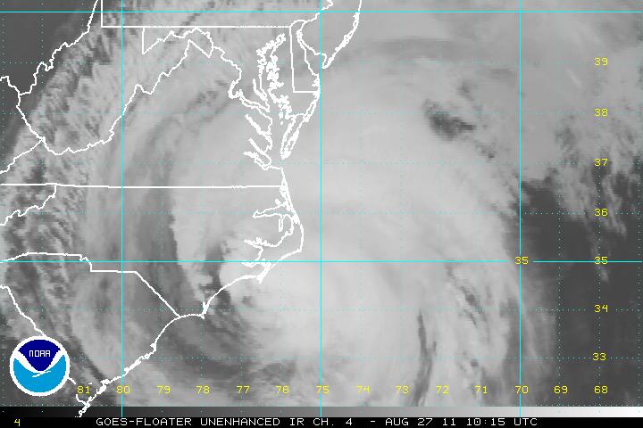
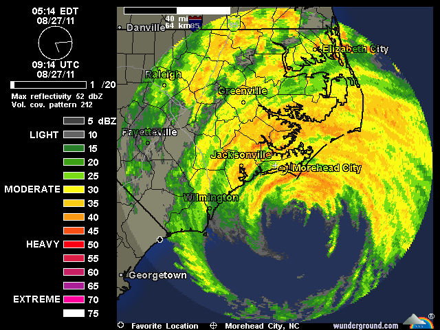
August 27th, 2011---: Irene is still on track to affect the NYC/NJ and Long Island area beginning late this afternoon, with the worst conditions coming in late tonight and into the day on Sunday. As is common with storms moving up the east coast of the US, the worst conditions will be in the northern and eastern semicircle of Irene. These storms have a tendency to become lop sided as they head poleward, and Irene is no exception. So as many of you have already heard, Hurricane Irene has been downgraded to a Category One hurricane, and I expect her to be either a Category One hurricane, or perhaps a strong Tropical Storm by the time she makes land fall here in our area tomorrow morning. This may lull some folks into a false sense of security, but if you live near the coast, or in a flood prone area, don't be fooled. This storm is still pushing a lot of water ahead of it and flooding is still a major concern for us. In fact, I think that is the number one threat from Irene, storm surge and flooding. The worst flooding can be expected east of the center of circulation. So if the center passes over NYC itself, then the worst flooding can be expected east of here over Nassau and Suffolk Counties. If the center passes over central NJ, then the worst of the flooding will be from NYC eastward. Regardless, with the amount of rain that Irene is forecast to dump on our area, major flooding is going to happen no matter what. So again, if you live in a flood prone area, be aware of this threat and please heed all warnings for your area. Again, common sense goes a long way. For all official watches and warnings refer to your local news outlets and emergency management broadcasts.
As far as my plans go, I will be teaming up with Mark Robinson and George Kourounis from Toronto Canada. They will be arriving at my place today around noon time along with my regular chase partner, Dave Lewison. At that point we will begin scouting various areas around Queens, and Long Island to document the storm from. I have a feeling that we won't be getting much sleep tonight due to the fact that we will have to be up and out very early tomorrow morning to begin documenting the storm. Conditions are expected to really start going down hill late tonight. I will also begin live streaming (video and audio) starting late tonight and will run the stream through the duration of the storm, or until my power goes out. If you would like to view the live stream, you can do that right here on my website by clicking on the "Live Streaming" link on the navigation bar at the top of this page, or you can click here to be taken to my streaming page. I will be posting a notification both here, and on my Twitter feed once live streaming begins very late tonight. But at any point tomorrow you can head there as it should be up and running. Back to the potential power outage issues for a moment, plan for these as well and make sure you have flashlights, batteries, and a battery operated radio on hand just in case your area loses power. For any further updates please refer to my Twitter feed as I may not have time to update again here before Irene bears down on us. To sum up, don't take Irene lightly, some folks are saying this won't be a big deal at all, and for some of us, it might not be that big of a deal depending on exactly where you are located. But if you happen to live in an area that gets inundated with water, or a tree comes down on your car or home, it sure is not going to feel like "nothing" to you so again, take all necessary precautions and keep yourself safe. Finally, even tropical storm force winds can do a lot of damage and we are expecting winds ranging from 50-90mph at times late tonight and tomorrow so beware of this as well.
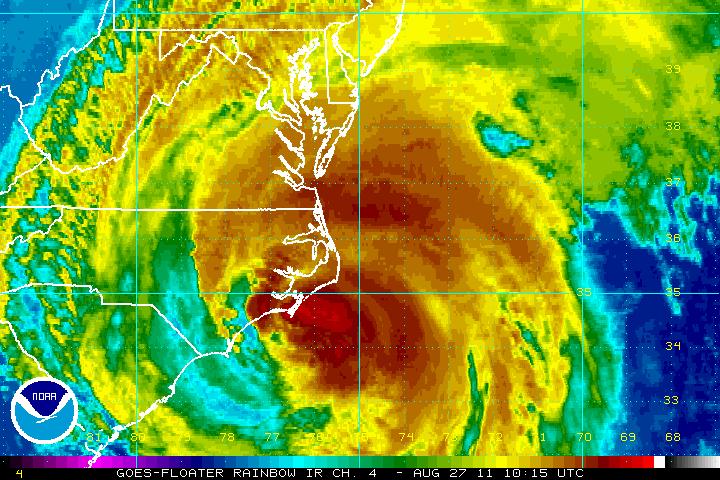
Images Below: Satellite shots of Hurricane Irene making her way north along the Atlantic coast, and a radar animation of her making her first land fall near the outer banks of North Carolina. The center of circulation is clearly visible just off shore.
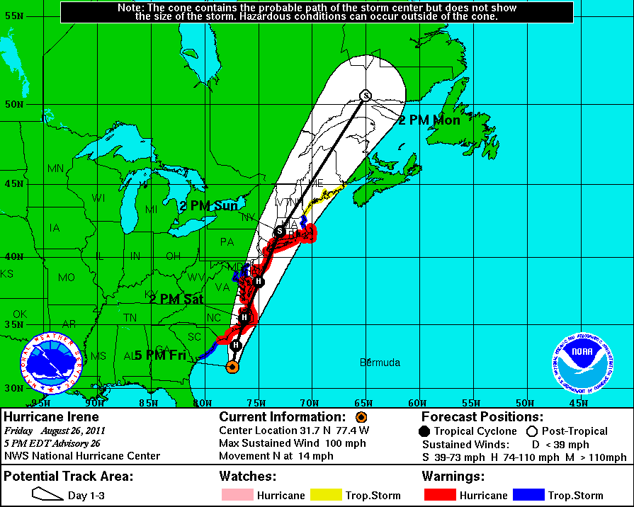
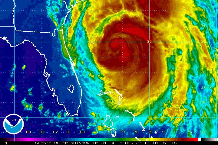
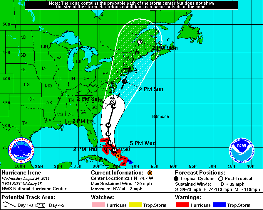
August 26th, 2011 (6pm Update)---: Ok, I've been keeping tabs on Irene all day today and the track still looks on target for the most part. Nothing much has changed since my update this morning regarding that, and the National Hurricane Center has left the track essentially unchanged. As far as Irene's intensity is concerned, she has weakened a bit today and now has maximum sustained winds at her core of 100 mph which keeps her at Category Two strength. It is entirely possible that when she reaches the NY/NJ/LI area that Irene could weaken below hurricane strength and be a strong Tropical Storm with maximum winds just below the threshold of hurricane strength. But, don't be fooled by this. What makes Irene still a dangerous storm, regardless of whether she is a Cat 1 hurricane or a strong tropical storm is the fact that she is massive, about 500 miles in diameter in fact. Tropical storm force winds extend out over 200 miles from her center, and she will also be pushing a good amount of water ahead of her as well. My personal opinion, and it's just that, my opinion, is that the biggest threats that we will face here will be flooding from torrential rains, and storm surge. So the warnings to evacuate the low lying and flood prone areas should be heeded! You know your area the best obviously, if you are prone to flooding, don't mess around, move inland and wait until the threat has passed. As far as wind damage is concerned, I feel confident that we will see a good bit of that too. Even winds in excess of 50 mph can do some extensive damage. And keep in mind, the strong winds that we will be experiencing here will last for several hours. With all the recent flooding rains, the ground is already saturated, and the root systems on many of the older trees have already been compromised. It won't take much to bring them down. Another issue that some areas might experience will be power outages, so plan for those as well. Again, hope for the best. It has been said to me by some that the media is over reacting and hyping things up too much. And to some extent I agree. But they walk a fine line if you think about it. If they down play the threat and someone gets hurt, or the storm is worse than expected, you all of a sudden have a bunch of people screaming "WE WEREN'T TOLD IT COULD GET THIS BAD!!!" but if they hype it up, and it's a dud, then you have people saying "Ah you see, it wasn't that bad, I knew it" lol. So it's almost a lose lose situation really. Again folks, common sense goes a long way here.
Regarding evacuations, etc...I have heard already on the local news as I am sure you have too that all mass transit will be suspended as of noon tomorrow. No buses, subways, trains, etc. So be sure to plan for that. I have also heard that the Rockaways will be under a mandatory evacuation, as will other parts of the area. Tune to your local news for all that info as I am still a bit foggy on everything as I type this. Other than that, I'm all set here and have planned for possible power outages, I also picked up some water just in case, and I gassed up my Xterra. I plan on being out documenting the storm for the duration and will also be live streaming (video and audio) from my house beginning early Sunday morning. I will be posting frequent updates on my Twitter page throughout the day as well. I will post a notification here early Sunday morning when live streaming begins, and will post another update tomorrow morning. Have a good night everyone!
Top Image: The latest 5pm track for Hurricane Irene issued by the National Hurricane Center. Bottom Image: A recent infrared satellite image of Irene making her way north up the east coast.
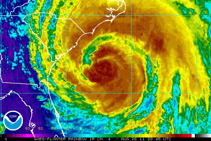
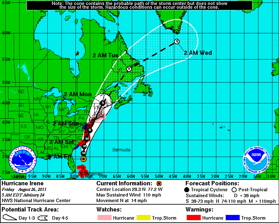
August 26th, 2011 (7:30am)---: Things still look on track from the National Hurricane Center this morning, and Hurricane Irene is expected to move ashore somewhere near the NYC metro this coming Sunday. There will be slight fluctuations in the track but the way it looks right now, and has continued to look for about two days now is that the center of Irene will move ashore somewhere on central or western Long Island. Again though, do not focus on just the center of Irene, she is huge and her wind radius is very wide, several hundreds of miles wide in fact so her affects will be felt all around our area regardless. Right now you have probably heard that Irene has fallen slightly below Category 3 strength to a Category 2. Not much of a difference in this case, at least for now as her maximum sustained winds are at 110 mph, and a category 3 storm begins at 111 mph lol. So don't be fooled by the down grade. Hurricane Irene is still a very powerful hurricane. With that said, I highly doubt she will be a stong Cat 2 or Cat 3 storm when she gets to our neck of the woods. In my opinion, and remember...it's just that, we can expect a Category 1 hurricane with maximum sustained winds in the order of 75-90 mph. And there will be winds stronger than that in gusts, I would not be surprised to hear of a few weather stations around our area reporting wind gusts over 100 mph before all is said and done. Even a Category 1 storm can still do a lot of damage, and what's more, Irene is so large that she will be carrying quite a storm surge with her. These bigger storms in terms of over all coverage push an aweful lot of water ahead of them. So we could expect a storm surge more on the order of a Category 2 storm in spots. Where exactly are the surge prone areas in and around New York City and Long Island? I came across a very nice map last night outlining those area. You can toggle around, and zoom in to your location to see if you are at risk. To view this map (PDF File) Click Here. To sum up for now, heed all warnings for your area, and remember, while evacuations are a pain in the butt, they are put in place for a reason. Yes, sometimes they turn out to not be necessary in the end, but it's a heck of a chance that you are taking if you stay. Wouldn't it be better to play it safe? It's up to you of course but if you live in any of the flood prone locations, or right near the bays or Atlantic coast I highly urge you to move inland a bit and perhaps stay with some family and friends until the storm passes. I have been very impressed with the way the local Meteorologists have been handling this storm. Personally I like Channel 7 and Channel 4 news here in NYC and in my opinion, they have been doing a great job keeping the public informed. And all with minimal hype! I will have another update around 6pm this evening. On a side note, live streaming with audio will begin Sunday morning and will run for the duration of the storm from here at my homestead in Queens! I will post link info when the time comes both here, on Facebook, and on my Twitter Feed.
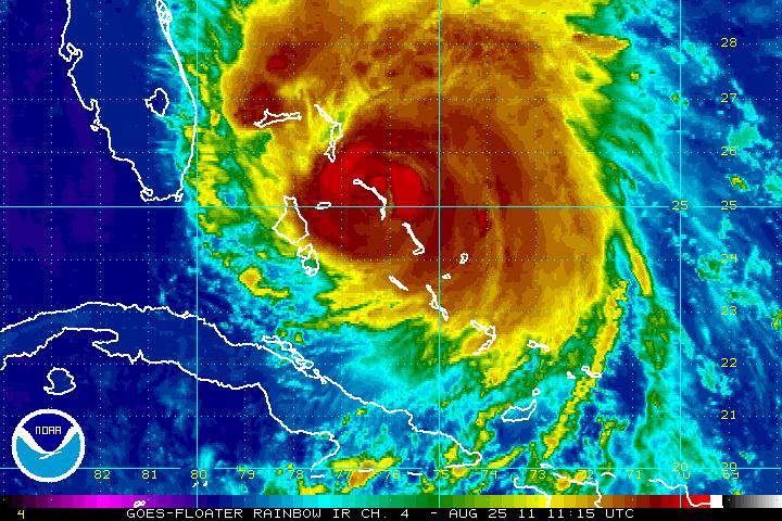
Top Image: The 5am track issued by the National Hurricane Center. Essentially the track has remained unchanged from yesterday. Bottom Image: A recent infared satellite image of Hurricane Irene as she churns up the east coast this morning.
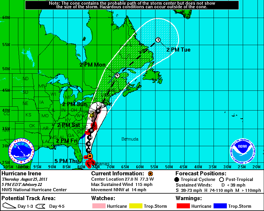
August 25th, 2011 (6pm Update)---: The latest from the National Hurricane Center as of 5pm has the track of Hurricane Irene essentially unchanged from the previous advisory. If anything, it's a tad more west now with the center of circulation forecast to move very near, or over the NYC metro. If this track verifies then the highest winds and storm surge would be just east of there, over parts of Long Island. If the track ends up being a bit more west, say over central NJ, then NYC would see the worst affects from the storm. Normally your highest winds and worst storm surge are just east of the center of circulation. While continued fluctuations in the track of Irene are certainly possible, what is becoming more certain is that we will take a big hit from Irene come late Saturday, and into the day on Sunday. This storm without a doubt should be taken seriously, and I have to say, I have been very impressed with the way our local news here in NYC has been handling this. They are providing very good information, without all the typical "hype" which usually runs rampant in situations like this. So with that said, heed all warnings for your area. The biggest threats from Irene will be heavy rains, high winds and flooding/storm surge. If you live in a flood prone or low lying area, heed all evacuation warnings. It is entirely possible that your area could be inundated with several feet of water. I have big concerns for my friends just south of me in Broad Channel, Queens. Jamaica Bay is right there and they are certainly prone to flooding there. Now, is it possible that the storm ends not being as bad as advertised? Sure, of course..but we can't assume that it will be. It's an old saying and kind of cliche' but I will say it anyway, plan for the worst and hope for the best. This storm is also forecast to come in at high tide, so any storm surge will be worsened by this. Here's something that I came across earlier today that I found very interesting. It's a storm surge map for the NYC area, and all of Long Island. To view this map, Click Here. You can zoom into your location once the map loads. It is also color coded. The "reds" will show areas that are prone to flooding in a Category One hurricane. The "oranges" are areas that can flood in a Category Two, and so on. Once again, for the latest advisories on Hurricane Irene tune into your local news, or visit the National Hurricane Center. I will have another update tomorrow morning by 9am.
Image Below: The latest 5pm track for Hurricane Irene from the National Hurricane Center
August 25th, 2011---: Just a quick update. Below is the latest 2pm track issued by the National Hurricane Center. Remember, do not focus on the dashed line which is the forecast track of the center of circulation. Irene is very large and her affects will be felt very far from the center of the storm. I have already begun preparations here today in Queens, NY at my house. If you would like more frequent updates regarding this storm, as well as general weather updates from around the NYC metro, be sure to follow me on Twitter as I will be posting much more often on there over the coming days.
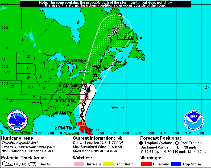
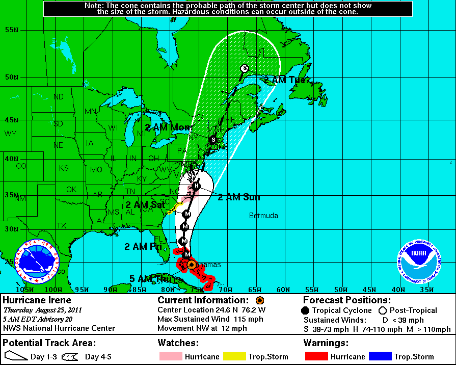
August 25th, 2011---: A very busy next few days here it seems. Going to brief my family shortly on the latest regarding Hurricane Irene, but first things first. As I type (8am) the threat of a land fall near the NYC/Long Island area is becoming more likely. The track guidance has shifted west from where the consensus was yesterday at this time. What does that mean? It means that it is becoming increasingly likely that the worst affects of Irene could be close to the NYC/NJ Metro, or perhaps over Long Island. All of this depends on the exact track of the storm, and I need to point this out once again, don't focus on that skinny black line or the dot on the map. That is just pointing out where the center of circulation is forecast to be, but this storm is hundreds of miles wide, and her adverse affects will be felt over a wide area. So essentially what I am saying is that it is looking highly likely at this point that strong winds and heavy flooding rains are a good bet for our area Saturday night, into Sunday. Just how bad we get it will depend on exactly where Irene decides to track. The forecast right now is calling for a track very near, or perhaps over the NYC metro. This could certainly change, but that is what it's looking like right now. Several factors will decide how strong Irene is once she gets here. Aside from her exact track up the eastern seaboard, how strong she is while moving up the coast is another factor. If she ramps up to a Category Four storm over the next day or so, then we *could* be looking at a strong Category One (strongest winds between 74-90 mph) or perhaps a low/mid end Category Two storm (strongest winds 90-105 mph) here in the northeast. If she decides to weaken more than expected over the next day or two, then we could be looking at strong Tropical Storm conditions up this way (winds gusting up to 70 mph or so) or perhaps a low end Category One storm (strongest winds in the 75-85 mph range). As you can see, it's just too early to tell right now.
So what should be done today. Begin preparing for the worst case scenario which would be a mid end Category Two hurricane this weekend here in the northeast. As the saying goes, prepare for the worst, and hope for the best. Pick up things like bottled water, canned goods, candles, batteries, flashlights, and have a battery operated radio, or even better...a NOAA weather radio on hand. Plan for potential power outages, and if you are in a flood prone area like some of my friends just south of me in Broad Channel, heed any and all evacuation warnings! As far as securing all loose objects around your property, I personally don't see the need to do any of that today. If by tomorrow/Saturday morning things are still looking bad for our area, then yes...those steps should be taken. And remember, don't panic. The media has a tendency to hype things up big time. They do this for two reasons in my opinion. First and foremost, for ratings. But, they also want to really drive the point home that these storms should be taken very seriously. And they are absolutely right, they should be taken seriously. But, think with a clear head is all I'm saying. Take it serious, and heed all warnings from the weather service. Coastal locations are at the biggest risk from these storms, so again, if you live near a river or stream that is prone to flooding, or you live near the Atlantic coast, don't downplay this. Flooding is very likely so plan accordingly. And, as you know, high winds can and will bring down trees and power lines in the area, so don't go venturing outdoors once the storm gets here. That's my job lol. So to sum up for now, in a nutshell, yes there is a very real threat that Hurricane Irene could hit our area this weekend. She could still pack quite a punch when she gets here, but how much of a punch is still unknown. Begin preparations, make a list, and listen to your local news for the latest. More updates later.
Top Image: The latest 5am track from the National Hurricane Center showing Irene potentially tracking right over Long Island. Bottom Image: Latest infared image of Hurricane Irene lashing the Bahama Islands.
August 24th, 2011---: Ok, I'm switching all blogging on Hurricane Irene over to my NYC weather blog since it's looking a bit more likely that we here in NYC, as well as the rest of the northeast are going to have to deal with her affects this weekend. The latest 5pm update from the National Hurricane Center has seen a shift a bit westward in the track. Over the last few days the track has been steadily shifting eastward, this is the first time we have seen a shift towards the west. The reason for this is that a few of the reliable forecast models have trended that way. Again, nothing written in stone yet, and there is no need to panic. What should folks here do? Simple, for now get a plan of action in place. Make a list of essential items and pick them up tomorrow. Bottled water, some cash on hand, canned good, batteries, flash lights and candles are essential items. Gas up your vehicle as well, and if you are in a flood prone area, have an evacuation plan in place. Make sure you have somewhere to go, and make a list of things that you need to bring with you, like important papers/documents, etc. I'm not gonna lie, Irene does have the potential to be a very powerful hurricane still when she gets up this way. The exact track will be crucial in determining exactly which areas, if any see the worst of conditions. It's just too early to tell that right now. But, the potential is there, and preparations should begin. By all accounts this storm should be taken seriously. It's always best to plan for the worst, and hope for the best. I have already began prepping my family here in NYC as to what to do in the event Irene set's her sights on the area. More updates to follow!
Below Image: The latest 5pm track for Hurricane Irene from the National Hurricane Center
August 24th, 2011---: Tracking Hurricane Irene in the Atlantic, and her threat to the NYC metro this weekend. Head on over to my "storm chase blog" for more details, and don't forget to follow me on Twitter for the most frequent updates on Irene, as well as any storms that threaten our area.
August 20th, 2011---: What a wild week of weather so far here in the NYC area! After the record breaking flooding event back on the 14th, we had a round of severe storms move through NYC on the 18th. No less than 24 hours later, another, more intense round of storms moved through my area, with tons of lightning, torrential rains and strong winds. Below is a radar screen shot of the storms and their respective severe warnings prior to them hitting the NYC metro yesterday evening. Tomorrow is shaping up to be quite significant. There is the possibility that we could be facing our biggest severe weather threat of the summer. However, nothing is written in stone, but stay tuned! If you have a Twitter account, be sure to follow me for the latest weather updates out of NYC. I will be updating throughout the day tomorrow.
August 15th, 2011---: We received some more heavy rains last night so here are the updated totals from this incredible storm. My location is now up to almost 6 inches of rain over the last 36 hours, and parts of Nassau County, LI have received almost a foot of rain from this storm!
PUBLIC INFORMATION STATEMENT
SPOTTER REPORTS
NATIONAL WEATHER SERVICE NEW YORK NY
1045 PM EDT SUN AUG 14 2011
THE FOLLOWING ARE UNOFFICIAL OBSERVATIONS TAKEN DURING THE PAST 24 HOURS
FOR THE STORM THAT HAS BEEN AFFECTING OUR REGION. APPRECIATION IS EXTENDED
TO HIGHWAY DEPARTMENTS...COOPERATIVE OBSERVERS...SKYWARN SPOTTERS
AND MEDIA FOR THESE REPORTS. THIS SUMMARY IS ALSO AVAILABLE ON OUR
HOME PAGE AT WEATHER.GOV/NYC
********************STORM TOTAL RAINFALL********************
LOCATION STORM TOTAL TIME/DATE COMMENTS
RAINFALL OF
/INCHES/ MEASUREMENT
CONNECTICUT
...FAIRFIELD COUNTY...
BRIDGEPORT AIRPORT 2.55 1040 PM 8/14 ASOS
NORWALK 2.00 742 PM 8/14 PUBLIC
BRIDGEPORT 1.97 355 PM 8/14 COOP
DANBURY AIRPORT 1.47 905 PM 8/14 ASOS
...NEW HAVEN COUNTY...
MADISON 2.60 715 PM 8/14 PUBLIC
NEW HAVEN 2.22 915 PM 8/14 ASOS
MERIDEN 1.94 922 PM 8/14 ASOS
...NEW LONDON COUNTY...
OLD LYME 2.39 600 PM 8/14 PUBLIC
COLCHESTER 2.00 545 PM 8/14 PUBLIC
GROTON 1.06 913 PM 8/14 ASOS
NEW JERSEY
...BERGEN COUNTY...
LODI 3.30 810 PM 8/14 MESONET
TETERBORO 3.06 924 PM 8/14 ASOS
RIDGEWOOD 2.35 400 PM 8/14 SKYWARN SPOTTER
...ESSEX COUNTY...
NEWARK AIRPORT 6.40 940 PM 8/14 ASOS
CEDAR GROVE 3.19 1030 PM 8/14 SKYWARN SPOTTER
CALDWELL AIRPORT 2.45 904 PM 8/14 ASOS
...HUDSON COUNTY...
HARRISON 5.70 943 PM 8/14 SKYWARN SPOTTER
KEARNY 4.50 1000 PM 8/14 PUBLIC
...PASSAIC COUNTY...
WAYNE 2.36 600 PM 8/14 SKYWARN SPOTTER
...UNION COUNTY...
ELIZABETH 6.65 830 PM 8/14 SKYWARN SPOTTER
NEW YORK
...KINGS COUNTY...
SHEEPSHEAD BAY 7.80 900 PM 8/14 SKYWARN SPOTTER
BROOKLYN 7.38 1030 PM 8/14 MIDWOOD COOP
...NASSAU COUNTY...
LIDO BEACH 10.87 625 PM 8/14 SKYWARN SPOTTER
WANTAGH 10.08 725 PM 8/14 SKYWARN SPOTTER
BELLMORE 9.07 520 PM 8/14 SKYWARN SPOTTEER
NORTH MASSAPEQUA 8.68 900 PM 8/14 PUBLIC
LYNBROOK 8.50 555 PM 8/14 SKYWARN SPOTTER
BETHPAGE 7.90 815 PM 8/14 SKYWARN SPOTTER
VALLEY STREAM 7.59 558 PM 8/14 SKYWARN SPOTTER
PLAINVIEW 7.47 900 PM 8/14 SKYWARN SPOTTER
FLORAL PARK 6.13 430 PM 8/14 SKYWARN SPOTTER
BAYVILLE 5.03 537 PM 8/14 PUBLIC
MUTTONTOWN 3.42 700 PM 8/14 SKYWARN SPOTTER
...NEW YORK COUNTY...
CENTRAL PARK 5.79 1043 PM 8/14 ASOS
...ORANGE COUNTY...
HARRIMAN 1.35 600 PM 8/14 SKYWARN SPOTTER
NEW WINDSOR 1.21 530 PM 8/14 PUBLIC
MONTGOMERY 0.41 921 PM 8/14 ASOS
...QUEENS COUNTY...
NYC/JFK AIRPORT 7.79 1040 PM 8/14 ASOS
HOWARD BEACH 7.00 722 PM 8/14 SKYWARN SPOTTER
NYC/LA GUARDIA 6.51 1040 PM 8/14 ASOS
REGO PARK 5.43 953 PM 8/14 SKYWARN SPOTTER
...ROCKLAND COUNTY...
NEW CITY 5.00 1035 PM 8/14 PUBLIC
...SUFFOLK COUNTY...
MOUNT SINAI 7.09 1021 PM 8/14 NWS EMPLOYEE
BABYLON 7.00 900 PM 8/14 SKYWARN SPOTTER
RIVERHEAD 6.20 807 PM 8/14 SKYWARN SPOTTER
DIX HILLS 6.17 400 PM 8/14 SKYWARN SPOTTER
EAST FARMINGDALE 6.13 907 PM 8/14 ASOS
CENTEREACH 5.45 809 PM 8/14 NWS EMPLOYEE
NORTH BABYLON 5.41 700 PM 8/14 SKYWARN SPOTTER
MATTITUCK 5.25 700 PM 8/14 SKYWARN SPOTTER
ISLIP AIRPORT 5.12 1040 PM 8/14 ASOS
SHIRLEY 4.25 915 PM 8/14 SKYWARN SPOTTER
LINDENHURST 3.96 954 PM 8/14 SKYWARN SPOTTER
SHIRLEY AIRPORT 3.82 917 PM 8/14 ASOS
UPTON 3.78 755 PM 8/14 NWS OFFICE
MEDFORD 3.55 900 PM 8/14 SKYWARN SPOTTER
SOUTHAMPTON 3.26 611 PM 8/14 SKYWARN SPOTTER
FIRE ISLAND 2.80 810 PM 8/14 MESONET
WESTHAMPTON BEACH 2.77 909 PM 8/14 ASOS
ORIENT 1.78 820 PM 8/14 SKYWARN SPOTTER
...WESTCHESTER COUNTY...
WHITE PLAINS 2.72 913 PM 8/14 ASOS
YORKTOWN HEIGHTS 2.21 535 PM 8/14 SKYWARN SPOTTER
August 14th, 2011---: Holy cow what a surprise today was! We were expecting a few inches of rain here in the NYC area, what we ended up getting, and are still getting is a LOT more than a few inches. The rains began yesterday evening and I was awoken several times last night by flashes of lightning and rumbles of thunder. It was clear at this point that we might be dealing with a bit of flooding once dawn broke, that was an understatement. By the time I got up this morning around 7am, we already had over 3 inches of rain which had fallen since midnight. And it just kept pouring all morning and into the afternoon. I went out around 10am and began shooting some video locally here in Middle Village/Rego Park, Queens. Several roads were already flooded out and I found one in particular where the water was really deep. The intersection of Metropolitan Ave & Cooper Ave here in Middle Village is where I set up shop and shot some video. See my "Latest Storm Videos" page for the video! After getting soaked to the bone, I decided to head back and tend to things here. Thankfully we haven't had to deal with any big time flooding here at my place, but there was some water in the basement and I'm hoping with more heavy rains expected later that I don't wake tomorrow morning to a basement full of water. The rain totals throughout the area are staggering. JFK Airport recorded it's wettest day on record! Over 7 inches of rain had fallen there, with over 5 inches already here at my place. That's nothing compared to Lido Beach in Nassau County, LI! They have had over 10 inches of rain already. And it's not over yet, more rain is on the way for later tonight, and throughout the day tomorrow. While it's not expected to be as steady as it was today, we could still see some bouts of heavy rain over the next 24 to 36 hours.
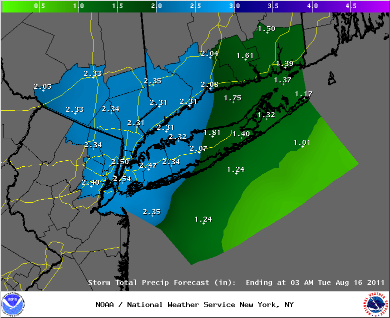
Image Below: The latest rain fall totals forecast issued by the National Weather Service here in NYC. This is not what has fallen since midnight last night, this is what is expected to fall between now and early Tuesday morning! As you can see, it's not over yet! Below that is the latest rundown on rain fall totals for the area. These totals will be adjusted once the storm departs the area, and I will post the updated totals once they become available tomorrow evening.
PUBLIC INFORMATION STATEMENT
SPOTTER REPORTS
NATIONAL WEATHER SERVICE NEW YORK NY
522 PM EDT SUN AUG 14 2011
THE FOLLOWING ARE UNOFFICIAL OBSERVATIONS TAKEN DURING THE PAST 24 HOURS
FOR THE STORM THAT HAS BEEN AFFECTING OUR REGION. APPRECIATION IS EXTENDED
TO HIGHWAY DEPARTMENTS...COOPERATIVE OBSERVERS...SKYWARN SPOTTERS
AND MEDIA FOR THESE REPORTS. THIS SUMMARY IS ALSO AVAILABLE ON OUR
HOME PAGE AT WEATHER.GOV/NYC
********************STORM TOTAL RAINFALL********************
LOCATION STORM TOTAL TIME/DATE COMMENTS
RAINFALL OF
/INCHES/ MEASUREMENT
CONNECTICUT
...FAIRFIELD COUNTY...
BRIDGEPORT AIRPORT 2.21 421 PM 8/14 ASOS
BRIDGEPORT 1.97 355 PM 8/14 COOP
NORWALK 1.50 1231 PM 8/14 PUBLIC
DANBURY 1.37 426 PM 8/14 ASOS
...MIDDLESEX COUNTY...
FLORAL PARK 4.38 930 AM 8/14 SKYWARN SPOTTER
...NEW HAVEN COUNTY...
NEW HAVEN 1.81 453 PM 8/14 ASOS
MERIDEN 1.63 502 PM 8/14 ASOS
...NEW LONDON COUNTY...
GROTON 1.05 451 PM 8/14 ASOS
NEW JERSEY
...BERGEN COUNTY...
TETERBORO 2.52 510 PM 8/14 ASOS
GARFIELD 2.44 1210 PM 8/14 SKYWARN SPOTTER
RIDGEWOOD 2.35 400 PM 8/14 SKYWARN SPOTTER
...ESSEX COUNTY...
NEWARK AIRPORT 4.40 445 PM 8/14 ASOS
CALDWELL 1.94 423 PM 8/14 ASOS
...HUDSON COUNTY...
HARRISON 3.54 441 PM 8/14 SKYWARN SPOTTER
...PASSAIC COUNTY...
WAYNE 1.97 200 PM 8/14 SKYWARN SPOTTER
NEW YORK
...KINGS COUNTY...
SHEEPSHEAD BAY 7.25 330 PM 8/14 SKYWARN SPOTTER
BROOKLYN 6.28 315 PM 8/14 MIDWOOD COOP
1 SE PARKVILLE 5.85 1214 AM 8/14 NWS COOP
...NASSAU COUNTY...
LIDO BEACH 10.20 1230 PM 8/14 SKYWARN SPOTTER
MASSAPEQUA PARK 8.17 1230 PM 8/14 SKYWARN SPOTTER
BELLMORE 8.04 1200 PM 8/14 SKYWARN SPOTTER
PLAINVIEW 7.33 500 PM 8/14 PUBLIC
FREEPORT 7.04 1240 PM 8/14 EMERGENCY MANAGER
NORTH MASSAPEQUA 7.00 1230 PM 8/14 PUBLIC
FLORAL PARK 6.13 430 PM 8/14 SKYWARN SPOTTER
FARMINGDALE 5.98 446 PM 8/14 ASOS
MASSAPEQUA 5.40 1100 AM 8/14 SKYWARN SPOTTER
MUTTONTOWN 2.99 100 PM 8/14 SKYWARN SPOTTER
...NEW YORK COUNTY...
CENTRAL PARK 4.62 420 PM 8/14 ASOS
...ORANGE COUNTY...
MONTGOMERY 0.36 1200 PM 8/14 ASOS
...QUEENS COUNTY...
NYC/JFK AIRPORT 7.60 458 PM 8/14 ASOS
HOWARD BEACH 5.97 1130 AM 8/14 SKYWARN SPOTTER
NYC/LA GUARDIA 5.71 500 PM 8/14 ASOS
...SUFFOLK COUNTY...
DIX HILLS 6.17 400 PM 8/14 SKYWARN SPOTTER
EAST FARMINGDALE 5.98 446 PM 8/14 ASOS
CENTEREACH 5.11 253 PM 8/14 NWS EMPLOYEE
MOUNT SINAI 5.09 200 PM 8/14 NWS EMPLOYEE
NORTH BABYLON 4.64 1200 PM 8/14 PUBLIC
ISLIP 4.11 400 PM 8/14 SKYWARN SPOTTER
ISLIP AIRPORT 3.88 457 PM 8/14 ASOS
RIVERHEAD 3.10 430 PM 8/14 PUBLIC
SHIRLEY 2.98 457 PM 8/14 ASOS
MIDDLE ISLAND 2.71 145 PM 8/14 NWS EMPLOYEE
UPTON 2.13 200 PM 8/14 NWS OFFICE
WESTHAMPTON 2.09 450 PM 8/14 ASOS
ORIENT 1.54 1240 PM 8/14 SKYWARN SPOTTER
MONTAUK 0.20 510 PM 8/14 ASOS
...WESTCHESTER COUNTY...
WHITE PLAINS 2.69 452 PM 8/14 ASOS
August 7th, 2011---: Nothing much of note here the past few days, unless you're talking about the insane hail storms that occurred last Monday, August 1st just east of my in Nassau County, LI! Hail, at times up to baseballs were reported in Great Neck and New Hyde Park! This is incredible for our area. I cannot ever remember hearing about hail that big here in the NYC area. But, it can happen as we have seen. Unfortunately I was stuck in traffic trying to get out to these storms. Saw nothing at all that day. Oh well, that's chasing in the NYC metro for you! In other news, there is the chance of storms again today, tomorrow and basically into mid-week. But, only slight chances each day. Today though we are getting a good amount of sun breaking through the clouds so I will be on the looking for any storms later on this afternoon. You never know.
On a totally separate note, I'll be a guest on the Joan Hamburg Radio Show which airs on WOR Radio 710 on your am dial. If you're in and around the NYC area, tune in between noon and 2pm next Monday, August 15th! Meteorologist Janice Huff from NBC 4 NY will be guest hosting and she has asked me to come on the show and talk about my storm chasing experiences. Should be a blast!
July 28th, 2011---: The Storm Prediction Center has my area, as well as much of the Lower Hudson Valley and northeast New Jersey in a slight risk category for severe storms tomorrow afternoon and evening. Much will depend on if an MCS (Mesoscale Convective System) affects us later this evening, and how much cloud cover exists once we get into tomorrow morning. With enough sunshine, the atmosphere will destabilize and severe storms will be a good possibility. Wind shear will be present tomorrow, mostly in the form of speed shear so the dynamics appear to be there to sustain the updrafts in any thunderstorms that do form. The biggest threat I see right now from any storms that do form will be strong, possibly damaging winds and torrential rains. I'll be keeping tabs on the situation for sure and will post throughout the evening and of course, tomorrow on my twitter feed. If storms look like a good bet come tomorrow morning, I may head out to try my hand at local chasing. Chasing in and around the NYC area is usually a lesson in frustration, but if it looks worth it, and the risk appears to be north of NYC, I may take the plunge. Stay tuned! Image Below: the latest Day Two Outlook from the Storm Prediction Center showing severe weather risk areas for tomorrow.
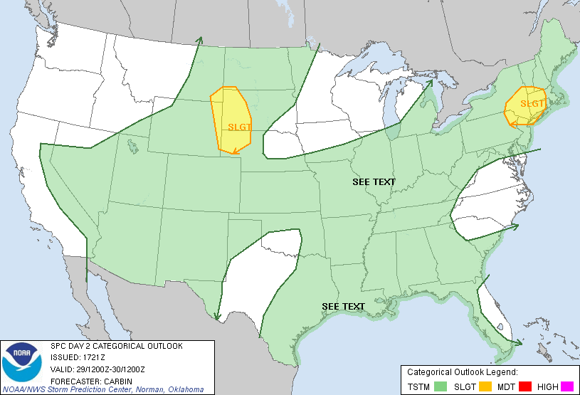
July 25th, 2011---: What a heat wave we had here in NYC late last week! We finally got a taste of what folks in the midwest states have been going through all summer. Part of that heat ridge broke off and headed in our direction last Thursday when temperatures topped out close to 100 degrees here in the NYC metro. But that was nothing compared to the heat and humidity we experienced on Friday, July 22nd! Central Park recorded it hottest temperature since July 21st, 1977.....104 degrees! I recorded the same here at my place in Rego Park, Queens NY. What more is that our dewpoints were in the mid 70s making it feel down right oppressive. It was tough to be outside for more than a few minutes that day. Saturday, July 22nd was only slightly better. We topped off at 101 here in Queens and yesterday, we hit 92. The heat wave is broken today with temperatures only forecast to make it into the mid 80s, but this will be short lived. The heat ridge that has retrograded back west will make another push towards us once again later this week, and by Friday we could be back into the mid 90s once again. So get ready for heat wave part two here in the northeast! If you're looking for any relief from storms, our best chance will be today and tonight with the passage of a cool front. We could see some storms in and around the NYC metro, but the best chances are for areas north and west of us over PA, NJ and the Lower Hudson Valley. Another shot at rain could come on Thursday evening, and our next chance for big storms as it looks right now would be on Friday. Image Below: I had never recorded a temperature so hot at my location, so I took a picture of it. This was taken right around 3pm back on July 22nd.
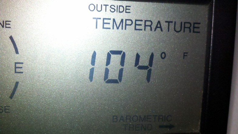
July 21st, 2011---: The heat is ON for the next few days in and around the NYC Metro! High heat combined with high humidity will make for oppressive conditions, especially here in the crowded city. High temperatures today should top off in the mid and upper 90s, but tack on the humidity and it will feel more like 105 to 115! Definitely a day to take it easy for sure. I'll be hitting my local gym in a bit, but there will be no running outside for me today, or tomorrow for that matter. Tomorrow is forecast to be even hotter than today with high temperatures topping out around 100 for NYC.Unfortunately there is little chance of relief in the form of showers and thunderstorms. Only about a 10% chance for today, and about a 20% chance for tomorrow. If a storm does form, it would be welcome relief for sure! Below are the forecast high temperatures for today, and for tomorrow.
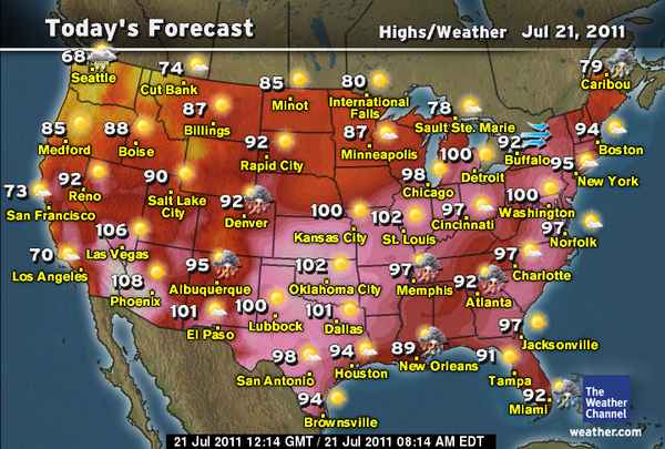
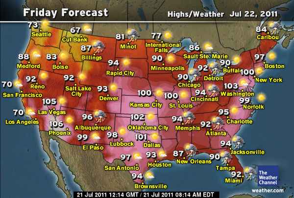
July 17th, 2011---: The heat is going to get turned up here in the northeast this upcoming work week. And it will really get turned up towards the middle and latter part of the week. First things first though. The Storm Prediction Center has us here in the NYC Metro in the slight risk category for severe storms tomorrow afternoon and evening. There is the potential for some pretty strong storms moving through the area tomorrow so keep an eye to the sky, especially later in the day. This threat also covers my friends out on Long Island as well. The period after that (Tuesday & Wednesday) will feature a brief cool down, if you even want to call it that, but then the heat really gets turned on. Both the GFS and ECMWF (Euro) have been hinting at an extended heat wave taking shape in the northeast for several days now. The intense high pressure system that has been bringing extreme heat to many states out west begins to slide east, thus the heat will begin to move east. Temperatures in and around the heat islands of NYC and metro NJ could top out in the upper 90s at times late next week and into next weekend. Exactly how bad this potential heat wave will be is still uncertain as it is still several days away. I'll be keeping tabs over the coming days for sure. Images below: The 00z ECMWF (Euro) and 00z GFS Operational Run forecast temperatures for the next Friday time frame (July 22nd).
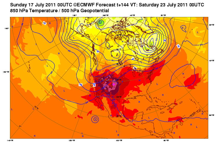
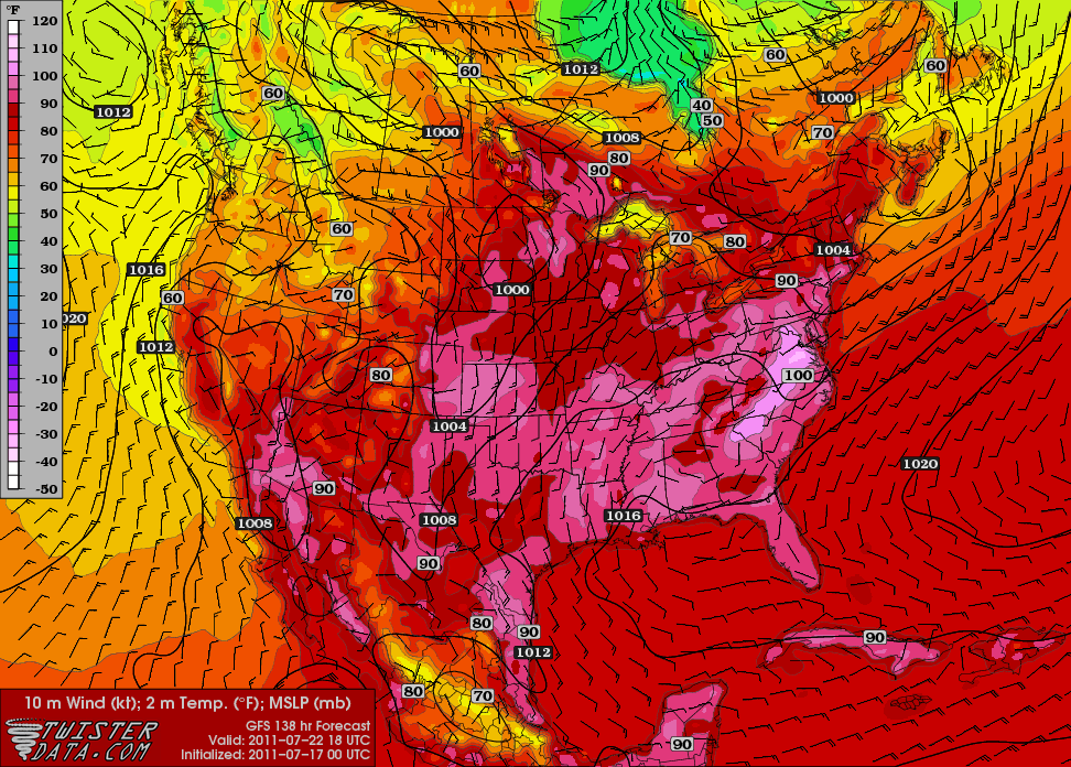
July 13th, 2011---: Well what do you know! Even though the humidity levels were much lower here in the NYC metro this afternoon, we had several things in place today, that were not in place yesterday when the temperatures and dew points were much higher. Today we had a vigorous shortwave trough moving through the northeast that created enhanced areas of lift, and that combined with lingering instability was enough to get some scattered storms going, unlike yesterday. We had brief but intense storm roll through my area around 7pm this evening, followed by an incredible rainbow! The next several days are looking warm, but dry. Pretty much straight through the weekend. After that, we could see some storms with a cold frontal passage either on Monday or Tuesday. In the more extended range, it's looking like the models are hinting at what could be an extended heat wave for us here in the northeast. This is still very much in the long range so the jury is still out for sure. But, I'll be keeping tabs on the situation for sure!
July 8th, 2011---: Strong thunderstorms moved through the NYC Metro yesterday afternoon and brought with them some much needed rains for my plants and herbs! Today could be a repeat of yesterday but the degree of instability is in question right now due to a good amount of cloud cover. Still though, heavy rain is a good bet later today for sure. Below is a radar screen shot of the storms as they plowed through my neighborhood of Rego Park/Middle Village, Queens yesterday afternoon. And below that is a surface map courtesy of WeatherTap showing the stationary front that is draped right through the NYC area. If that front can stay just north of us, then bigger storms are more likely this afternoon. If it sags a bit south, then central/southern New Jersey would be more in line to see the big storms. Right now the Storm Prediction Center has the area just to the south of NYC highlighted in a slight risk of severe weather for today. We'll see if that changes in later updates. More later!
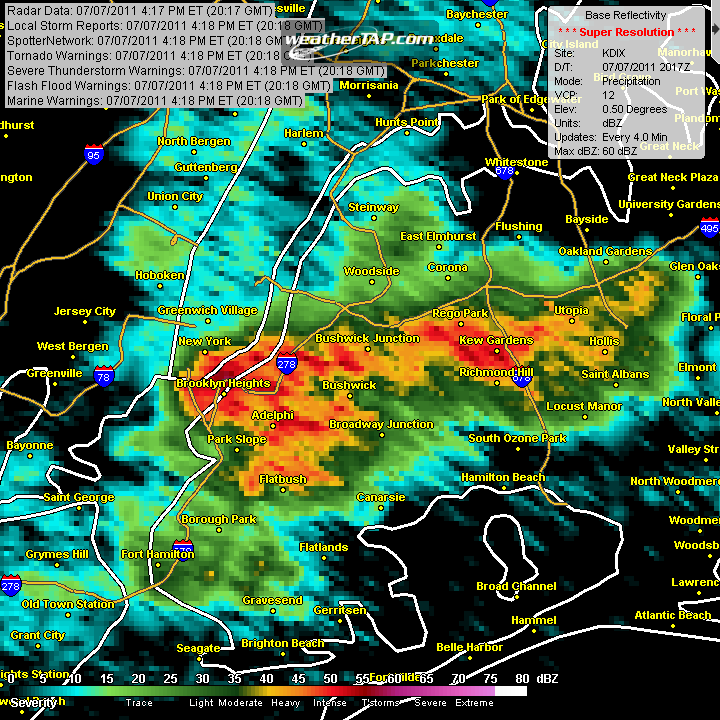
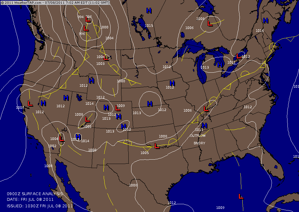
July 4th, 2011---: First off, Happy 4th everyone! Yes, my favorite holiday is finally here. All though I used to enjoy it a bit more when the police here in NYC were more lenient and would allow us to light off fireworks lol. Now there is zero tolerance here in the city so I'm delegated to lighting off a few bottle rockets and that's about it. Fortunately our big Macy's fireworks show will go this evening under mostly clear skies and temperatures around 80! Normally I would wish for thunderstorms since it is summer after all, but on the 4th of July if we are going to get storms, I prefer them early so the fireworks show can go off without a hitch. This year it appears that won't be an issue. While the forecast initially called for a 20% chance of storms today, the front has moved through and while the temperatures haven't dropped all that much, the humidity levels have begun to drop off, along with our chances of storms. Speaking of storms, our next significant chance of storms will come late Wednesday evening and into the day on Thursday. Details are still sketchy right now, but it appears that there will be enough instability that we could see some strong storms during the overnight hours on Wednesday. I'll have another update tomorrow regarding that! In the meantime, hope everyone enjoys their 4th of July holiday! I'm firing up the grill right now!
June 26th, 2011---: The past week or so in NYC hasn't offered up much of anything of note really. We did have a few days that held some good potential for severe storms last week, but due to the sun not being able to make an appearance on both of those days, we got a whole lot of nothing. Other parts of the area did however see some intense storms, and widespread flooding took place in parts of New Jersey, as well at several towns in the lower Hudson Valley. The last week featured a warm front that got hung up just west and south of the NYC metro. Unfortunately, we were on the cool and cloudy side of this front so yeah, if you're a storm fan like me you were sorely disappointed the past week lol. However, we are just now beginning summer and should have plenty more opportunities to see not just summer like temperatures, but storms as well! I am definitely a fan of the hot weather, and of course storms so needless to say, we are now coming into my favorite time of year! The upcoming work week will feature a chance of showers and storms on Tuesday, with average to slightly above average temperatures. Which for this time of year is in the low to mid 80s.
June 17th, 2011---: Several rounds of thunderstorms hit the NYC metro this afternoon with heavy rains, lightning, and in parts of the area...small hail! Things have cooled off now in the wake of the storms but it won't be long before the threat of storms return to my area. The weekend is looking great with just a 20% chance of storms, but all of next week will feature temperatures in the mid and upper 80s with a 30% chance of storms each day! Summer is here! Well, it will be in just 5 days. Below is a high res radar screen shot courtesy of WeatherTap HD showing the first line of storms moving through my neighborhood of Rego Park, Queens earlier this afternoon
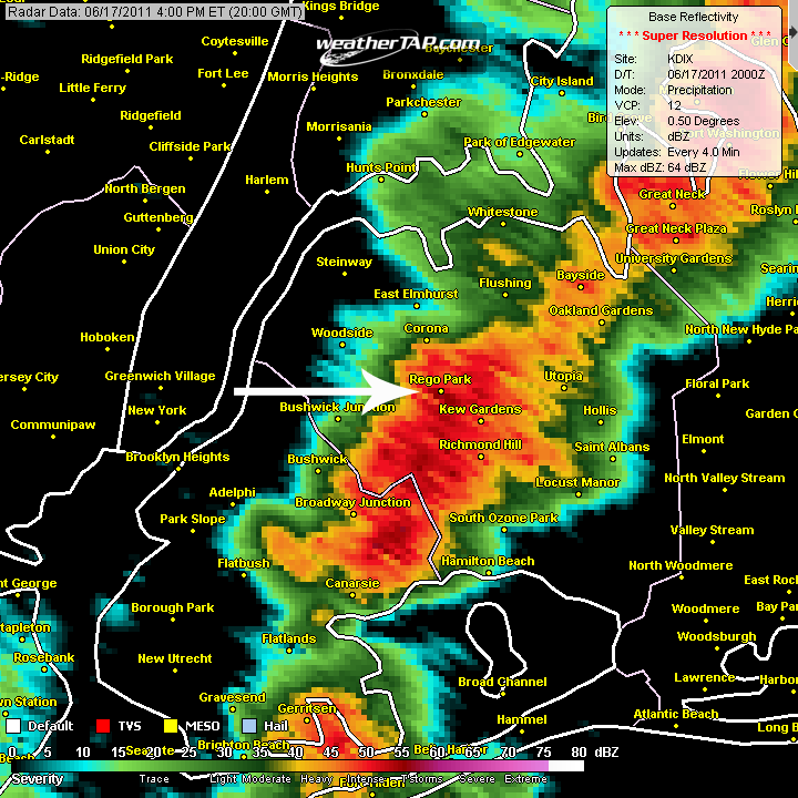
June 16th, 2011---: It's been a little over a month since I've last updated this page. For the past few weeks I was out chasing storms on the plains, and this year was very eventful to say the least. While we did see many amazing storms, there was also great tragedy as many big cities were hit hard this year and the death toll from tornadoes in 2011 has been staggering. But now I am settling back into the daily grind here in NYC and the past week was spent editing video, cleaning, gardening, and catching up with friends and family. In weather related news, things have been a bit on the cool side the past few days but we're now getting back to more seasonal levels for mid June. The temperatures have rebounded, but tomorrow will be a bit on the unsettled side. We're expecting some rain to move in after midnight tonight and there is even a chance of strong thunderstorms towards dawn tomorrow. The weekend is looking pretty great right now (fingers crossed as I am grilling for my dad on Sunday for Father's Day) and at least as it looks right now, next week will feature partly sunny skies, slightly above normal temperatures, and around a 30% chance of storms each day. Sounds good to me! Bring on the thunderstorms!!
May 12th, 2011---: For the time being I will be mainly concentrating on my storm chase blog since we are at the height of the severe weather season at this time, and if all pans out, I will be hitting the road soon for a few weeks of chasing! If you want to know the latest happenings, click on the "storm chase blog" link above to be re-directed. And don't forget to follow me on Twitter as I plan to update my feed several times a day from the road this spring!
April 24th, 2011---: What a difference a year makes! April 2010 featured record warmth for us here in the NYC area, not this year though. This month has been plagued by rain and below normal temperatures, with just a few hints of spring here and there. But this is about to change starting today as temperatures are expected to climb into the low 70s under partly sunny skies! And this upcoming week will feature more of the same! While there will be periods of unsettled weather to be dealt with here and there, we'll at least be warm. Temperatures will average near 70 tomorrow (Monday) and will warm even further into the mid and upper 70s as the week progresses. Could even see a few strong storms later in the week with the passage of a cold front. Below Image: Forecast high temperatures for this coming Tuesday. Now that's more like it!
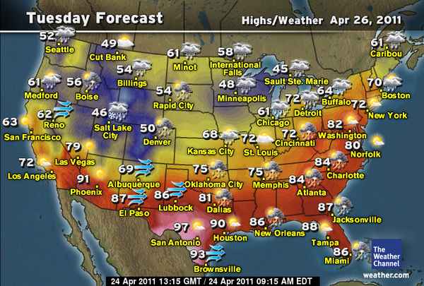
April 17th, 2011---: A 3-day severe weather event swept across the country over the last few days bringing with it many tornadoes and unfortunately, several casualties in the states of AL, MS and NC. We here in the NYC metro certainly did not see the worst of the weather, but we did get a narrow, but intense squall line move through the city last night around 11pm. In one hour we clocked in with over an inch of rain! What is it that they say? April showers bring May flowers? If that's the case then we should have a ridiculous amount of flowers around here next month, lol. Below Image: Radar screen shot courtesy of WeatherTap HD showing a narrow, but intense squall line moving through the metro last night.
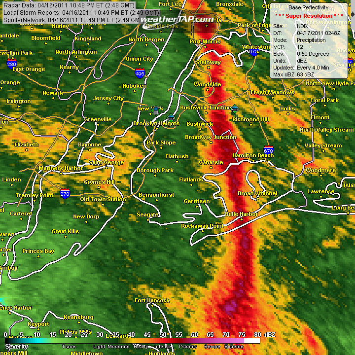
April 3rd, 2011---: The much awaited warm up for the NYC area is about to get underway, but it will come with a price. And that price will be periods of unsettled weather this upcoming week. But, scattered showers and storms is something that I will be more than happy to deal with in return for more spring like temperatures! And speaking of temperatures, if the warm front can move through early enough tomorrow, then it's possible that high temps will be higher than currently forecast. Right now the official forecast is calling for temperatures in the low to mid 60s for the NYC metro, but we could approach 70 if we can get enough sunshine during the late morning and afternoon, and areas away from the cooler ocean waters could see temperatures in the mid 70s! Unfortunately this time of year, being so close to the ocean screws us out of getting the warmest readings in the area, that onshore flow keeps us ten or more degrees cooler than areas in northeast NJ and the lower Hudson valley. For the rest of the week, we can expect temperatures near normal for this time of year which is in the lower and middle 50s.
One quick side note of weather history for you....37 years ago today the USA saw the start of the largest tornado outbreak in recorded history. Dubbed the "Super Outbreak" of April 3rd & 4th, 1974 there were 148 tornadoes reported during this outbreak. Truly an incredible event. To read more about the events of this historic outbreak, head on over to this fantastic website that has all the details of that event, including pictures, accounts and the reason why this outbreak occurred. Super Outbreak 1974 Website
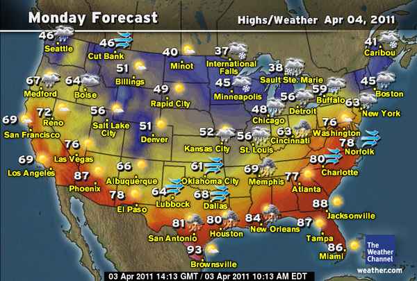
April 2nd, 2011---: A much overdue warm up is finally in store for the NYC metro! While we won't be summer like, we'll at least be spring like for a change. Overall we can expect the upcoming work week to be more seasonable, but unsettled at the same time. Still though, I'll take it!
March 30th, 2011---: Winter Storm Watches have been posted for much of the northeast with the exception of the NYC Metro. Here along the coast we're expecting little if any accumulating snows, but a good soaking of rain is very likely. All of this will take place Thursday night and into Friday. Along with the snow and rain will be strong gusty winds. Yes folks, a classic late season noreaster appears to be shaping up. For my friends living north of NYC, here's the latest winter storm watch info for your area (Click Here). For my friends in southern NY state and along the coast, here's your latest winter storm watch info (Click Here). Top Image: The latest snow fall totals forecast issued by the NWS this afternoon. As you can see, much of the NYC metro and Long Island will see little, if any accumulations. The best chance for those of us along the coast to see snow would be very late Thursday night and into Friday morning. Bottom Image: Latest rain fall totals forecast issued by the NWS this afternoon. Unlike the snow, my area along the coast could see up to 1 1/2 inches of rain. No matter what, it's looking like a really nasty go of it from late Thursday and into Friday.
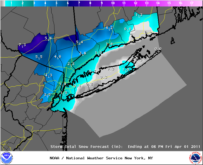
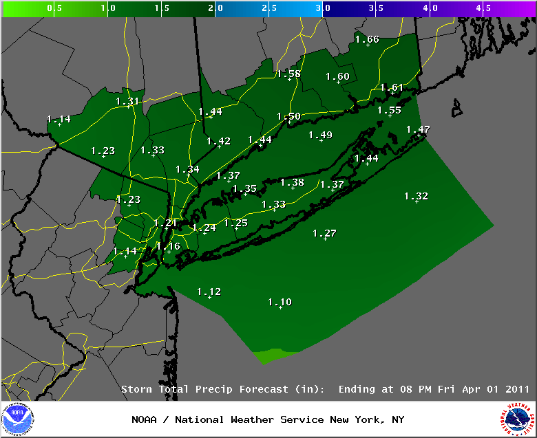
March 29th, 2011---: Well this just figures doesn't it? Just when you thought it was safe to put the shovels away we *may* need to bring them out once again this Friday. A significant noreaster is forecast by the major forecast models to take shape along the east coast, and depending on the exact track the NYC metro could see rain, snow or a mix of both. As of right now climatology would certainly lean on the side of rain, however, this as I mentioned all depends on the exact track. The 12z and 18z GFS have a track about 135 miles off shore of Long Island, where as the 12z ECMWF has a track about 100 miles off shore. The ECMWF is currently showing an all rain event and the GFS is showing a rain/snow mix early at the coast, followed by rain. With the GFS 850mb temps (5000 ft) below freezing, the surface temperatures would ultimately dictate precipitation type. Still way too early to tell exactly what will happen as usual, but I'll certainly be keeping an eye on things over the next 48 hours as things come more into focus. One thing does look likely, if this storm takes shape we can expect strong winds to affect the entire area late Thursday night and into the day on Friday. It's looking to be a nasty day regardless on whether we get rain or snow. For my friends that live north and west of NYC, those locations have a much higher likely hood of seeing significant snow fall, but again, it's still too early to give details on any of this. We'll just have to watch and wait. Below Image: 18z GFS forecast showing this potential noreaster off shore early Friday morning.
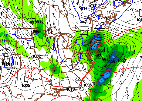
March 26th, 2011---: What gives! Where's spring already! Temperatures this morning in the NYC metro were more like January than late March. 27 degrees in Central Park this morning. Come on already, lol. Still no big warm up's in sight but they'll get here eventually, no worries. In the meantime, we have another storm system that will be passing to our south tomorrow. We can thank high pressure to our north for sparing us from any bad weather around here tomorrow. Expect partly cloudy skies and temps in the low 40s. Below Image: Low temperatures across the US this morning.
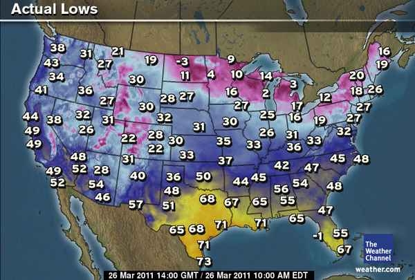
March 24th, 2011---: What a nice surprise last night! The NYC Metro got hit with a thunder "ice" storm. A rarity for these parts! Video now posted on my Latest Storm Videos page. Check it out!
March 23rd, 2011---: Gross is the best way to describe the weather here today in and around the NYC metro. Our early spring storm is bringing with it everything from rain, to sleet, hail pellets, and snow. Ugh, enough already! Well, we still have a way to go yet. Round two is on the way for later this evening and we can expect more rain to move into the metro after 8pm. Areas to our north and west could see another 6 inches of snow from this next round of precip! Because of this, the National Weather Service has continued their Winter Storm Warnings & Winter Weather Advisories for parts of the area. For the NYC metro and Long Island, expect an inch to perhaps 3 inches more of snow accumulation. However, I'm not expecting much of that to be sticking to the roadways. My thinking is that the roads will mostly be wet and not snow covered around the metro, but make no mistake, there will be slippery spots for sure so use caution if you plan to be out and about late this evening and into the overnight. Speaking of the overnight, any mixed precipitation is expected to change back to all snow throughout the area after 2am. Between 2am and 8am tomorrow morning is when we should see any accumulating snows. Hang in there, Spring will make an appearance again at some point, lol. Below Image: The latest snow fall totals forecast for this next round of snow later tonight.
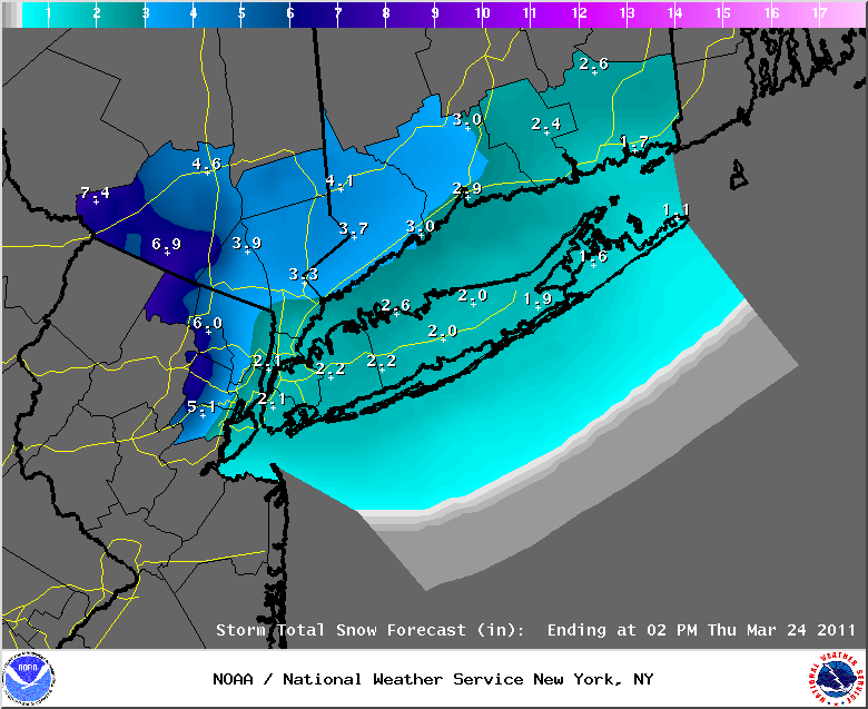
March 22nd, 2011---: Ugh! And here I thought we were done with this garbage already, lol. Nope...more snow is on the way for the NYC tri-state area tomorrow. However, for those of us in and around the NYC metro and Long Island do not fret, only a trace to perhaps an inch of snow is expected from this storm. Locations to our north and west however could be in for up to 6 inches of snow in spots, and therefore the National Weather Service has issued Winter Storm Warnings & Snow Advisories for those particular areas. All in all it will be a cold, raw and rainy day here in the NYC tomorrow. Any snow that does fall will be early in the morning where up to an inch could accumulate, mostly on the grassy areas and cars. The streets for the most part should be just wet. Still though, use caution if you plan to be out and about tomorrow as there will most certainly be slick spots. More unfortunate news regarding the extended forecast, there doesn't appear to be any real warm up's in sight over the next week. Hang in there though, Spring will make an appearance again at some point! Below Image: Current snow fall totals forecast issued by the NWS.
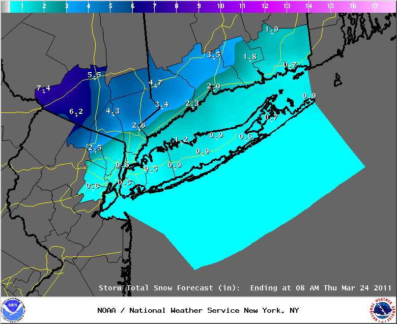
March 20th, 2011---: Well after a flat out awesome two days of super spring weather this past Thursday and Friday, temperatures cooled down big time on Saturday and we got a reality check saying yes...it's still only March. But, in happier news...it's finally spring! Today is the first official day of spring but no, it doesn't really feel like it. What's more, is that parts of the area could see an inch of snow later tonight and early tomorrow morning. Don't worry though, the forecast isn't even calling for advisory level snow fall. At best we're looking at trace amounts here in and around the city, with up to an inch north and west of the city. The bigger story will most certainly be the rain for tomorrow (Monday). Not a flat out deluge like last week which is definitely good news for the area residents living near some of the most flood prone rivers, but none the less, we are still looking at up to 1/2 inch of rain in spots. So there could be some flooding in spots. The NWS will be keeping tabs on that of course, and if any flood watches are posted, I'll update things here. The rest of the week will feature mostly below normal temperatures with another shot of rain later in the week. Winter will not let go easily, but hang in there, it's coming! Image below: Current rain fall totals forecast for the NYC metro and surrounding.
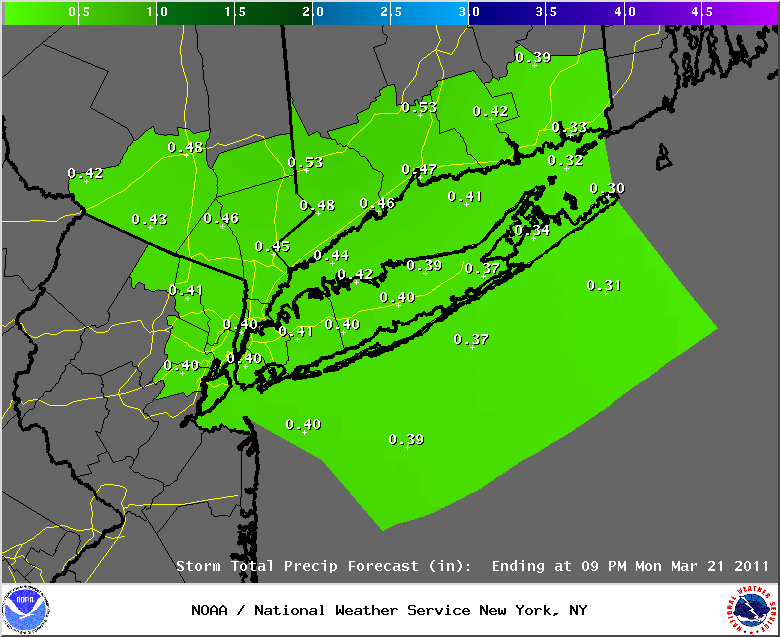
March 17th, 2011---: Just a quick update regarding tomorrow's weather. After a picture perfect day today we can expect one more round of the same tomorrow! If anything, it's likely to be about ten degrees warmer tomorrow! Temperatures in and around the NYC metro have a good shot at cracking the 70 degree mark! Enjoy it as we'll fall back into the 50s for the weekend.
March 16th, 2011---: Spring is about to hit the NYC metro with full force over the next two days. Today started off rainy but the rain is now outta here and now we're headed for a nice spring fling, at least for a few days anyways. Temperatures for tomorrow (St. Patrick's Day) will top out in the low 60s for the NYC metro, and Friday will feature even warmer temps with highs topping out in the mid to upper 60s. Unfortunately for those of us in coastal locations temperatures may struggle to get into the upper 60s due to the proximity of the cooler ocean waters. Locations away from the coast definitely have a shot at 70 degrees or better. There will also be a chance of rain on Friday with the passage of a cold front. This time of year, warm days usually come with a chance of rain, and some clouds..but we'll take what we can get! After the passage of the cold front, we'll drop back into the 50s for the weekend, which is normal for this time of year. Below Image: Forecast high temperatures for this coming Friday courtesy of weather.com
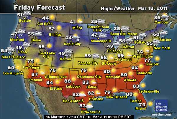
March 11th, 2011---: Here are the rain fall totals from around the NYC metro from our latest storm. I recorded a total of 2.16 inches here where I live in Rego Park, Queens NY which was about 1/2 inch more rain this time around, than what we saw from the storm a few days back. No matter which way you cut it, folks around the tri-state area are dealing with horrendous flooding conditions.
CONNECTICUT
...FAIRFIELD COUNTY...
DANBURY 2.15 1000 AM 3/11 ASOS
SAUGATUCK 1.49 730 AM 3/11 AFWS
3 SSE BROOKFIELD 1.45 700 AM 3/11 COCORAHS
SHELTON 0.90 610 AM 3/11 PUBLIC
STAMFORD 0.84 730 AM 3/11 AFWS
BRIDGEPORT 0.80 700 AM 3/11 NWS COOP
BRIDGEPORT AIRPORT 0.76 1000 AM 3/11 ASOS
...NEW HAVEN COUNTY...
ANSONIA 1.06 740 AM 3/11 NWS COOP
SOUTHBURY 0.90 1100 AM 3/11 SKYWARN SPOTTER
WOODBRIDGE 0.68 730 AM 3/11 AFWS
NEW HAVEN 0.61 1100 AM 3/11 ASOS
NORTH HAVEN 0.57 435 PM 3/11 PUBLIC
GUILFORD 0.55 730 AM 3/11 AFWS
MERIDEN 0.42 1000 AM 3/11 ASOS
...NEW LONDON COUNTY...
GROTON 0.84 1100 AM 3/11 ASOS
NORWICH 0.37 800 AM 3/11 NWS COOP
NEW JERSEY
...BERGEN COUNTY...
FRANKLIN LAKES 5.12 730 AM 3/11 AFWS
OAKLAND 5.03 800 AM 3/11 PUBLIC
WNW OAKLAND 4.52 700 AM 3/11 COCORAHS
1 ESE OAKLAND 3.90 700 AM 3/11 COCORAHS
1 SSE HAWTHORNE 3.53 600 AM 3/11 COCORAHS
RIDGEWOOD 3.31 545 AM 3/11 SKYWARN SPOTTER
LYNDHURST 3.10 830 AM 3/11 SKYWARN SPOTTER
GARFIELD 3.00 800 AM 3/11 SKYWARN SPOTTER
WOODCLIFF LAKE 2.81 730 AM 3/11 AFWS
RIVERVALE 2.80 718 AM 3/11 PUBLIC
2 S RIVER VALE TWP 2.75 700 AM 3/11 COCORAHS
PARK RIDGE 2.74 730 AM 3/11 AFWS
SADDLE BROOK 2.71 600 AM 3/11 PUBLIC
1 E SADDLE BROOK TWP 2.71 600 AM 3/11 COCORAHS
NNE SADDLE BROOK TWP 2.69 700 AM 3/11 COCORAHS
TETERBORO 2.26 1000 AM 3/11 ASOS
LODI 1.60 730 AM 3/11 AFWS
...ESSEX COUNTY...
CEDAR GROVE 3.85 600 AM 3/11 PUBLIC
VERONA 3.80 700 AM 3/11 SKYWARN SPOTTER
ESSEX FELLS 3.69 730 AM 3/11 AFWS
CALDWELL 3.32 530 AM 3/11 ASOS
NEWARK 1.92 730 AM 3/11 AFWS
NEWARK AIRPORT 1.83 700 AM 3/11 ASOS
...HUDSON COUNTY...
HARRISON 2.00 645 AM 3/11 SKYWARN SPOTTER
...PASSAIC COUNTY...
CHARLOTTEBURY 5.37 740 AM 3/11 NWS COOP
3 SSE WEST MILFORD T 5.06 700 AM 3/11 COCORAHS
3 NE WEST MILFORD TW 4.71 630 AM 3/11 COCORAHS
WEST MILFORD 4.64 730 AM 3/11 AFWS
RINGWOOD 4.62 730 AM 3/11 AFWS
WAYNE 3.80 645 AM 3/11 SKYWARN SPOTTER
NW WOODLAND PARK 3.69 700 AM 3/11 COCORAHS
1 SSW WAYNE TWP 3.64 700 AM 3/11 COCORAHS
WEST PATERSON 3.63 730 AM 3/11 AFWS
LITTLE FALLS 3.53 730 AM 3/11 AFWS
HAWTHORNE 3.53 534 AM 3/11 SKYWARN SPOTTER
NEW YORK
...KINGS COUNTY...
MIDWOOD 1.99 721 AM 3/11 NWS COOP
...NASSAU COUNTY...
MUTTONTOWN 1.39 1030 AM 3/11 SKYWARN SPOTTER
LYNBROOK 1.19 930 AM 3/11 SKYWARN SPOTTER
W FLORAL PARK 1.18 700 AM 3/11 COCORAHS
WANTAGH 0.97 830 AM 3/11 SKYWARN SPOTTER
MERRICK 0.86 500 PM 3/11 SKYWARN SPOTTER
FARMINGDALE 0.44 1044 AM 3/11 ASOS
...NEW YORK COUNTY...
CENTRAL PARK 1.98 1000 AM 3/11 ASOS
...ORANGE COUNTY...
TUXEDO PARK 3.81 611 AM 3/11 PUBLIC
CORNWALL-ON-HUDSON 3.68 647 AM 3/11 SKYWARN SPOTTER
NEW WINDSOR 3.65 1200 PM 3/11 SKYWARN SPOTTER
WARWICK 2.98 1010 AM 3/11 SKYWARN SPOTTER
PORT JERVIS 2.62 810 AM 3/11 NWS COOP
NEWBURGH 2.01 815 AM 3/11 SKYWARN SPOTTER
MONTGOMERY 1.85 1000 AM 3/11 ASOS
...PUTNAM COUNTY...
8 NE COLD SPRINGS 2.45 700 AM 3/11 COCORAHS
4 ESE BEACON 2.09 650 AM 3/11 COCORAHS
CARMEL 2.08 800 AM 3/11 NWS COOP
...QUEENS COUNTY...
NYC/LA GUARDIA 2.17 1000 AM 3/11 ASOS
REGO PARK 2.16 830 AM 3/11 SKYWARN SPOTTER
NYC/JFK AIRPORT 1.17 600 AM 3/11 ASOS
...ROCKLAND COUNTY...
NANUET 3.00 700 AM 3/11 AFWS
VALLEY COTTAGE 2.32 526 AM 3/11 SKYWARN SPOTTER
...SUFFOLK COUNTY...
NORTHPORT 1.01 730 AM 3/11 AFWS
2 NNE NORTHPORT 0.84 600 AM 3/11 COCORAHS
CENTERPORT 0.77 645 AM 3/11 NWS COOP
MONTAUK 0.66 1100 AM 3/11 ASOS
MIDDLE ISLAND 0.52 525 PM 3/11 NWS EMPLOYEE
WESTHAMPTON 0.51 1000 AM 3/11 ASOS
STONY BROOK 0.50 930 AM 3/11 SKYWARN SPOTTER
CENTEREACH 0.49 930 AM 3/11 NWS EMPLOYEE
UPTON 0.49 1100 AM 3/11 NWS OFFICE
MATTITUCK 0.45 1000 AM 3/11 NWS COOP
ISLIP AIRPORT 0.44 1000 AM 3/11 ASOS
FARMINGDALE AIRPORT 0.43 715 AM 3/11 ASOS
SHIRLEY 0.40 1000 AM 3/11 ASOS
LINDENHURST 0.40 645 AM 3/11 SKYWARN SPOTTER
BRIDGEHAMPTON 0.33 800 AM 3/11 NWS COOP
...WESTCHESTER COUNTY...
WHITE PLAINS 3.13 1045 AM 3/11 SKYWARN SPOTTER
YORKTOWN HEIGHTS 3.07 728 AM 3/11 SKYWARN SPOTTER
THORNWOOD 2.99 849 AM 3/11 SKYWARN SPOTTER
Click here to read my earlier entries from 2011